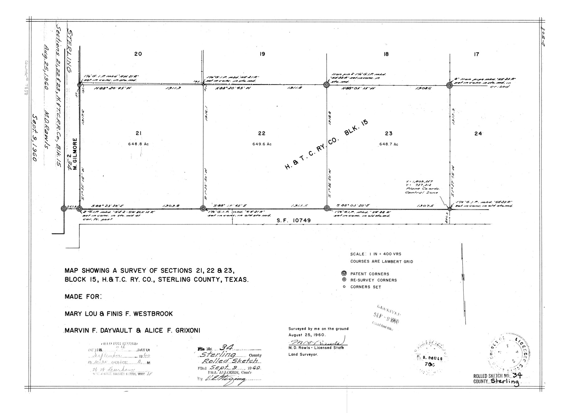
Sterling County Rolled Sketch 34
Map showing a survey of sections 21, 22, & 23, Block 15, H. & T. C. Ry. Co., Sterling County, Texas
-
Map/Doc
7858
-
Collection
General Map Collection
-
Object Dates
1960/8/25 (Creation Date)
1960/9/9 (File Date)
-
People and Organizations
M.D. Rawls (Surveyor/Engineer)
-
Counties
Sterling
-
Subjects
Surveying Rolled Sketch
-
Height x Width
16.0 x 21.8 inches
40.6 x 55.4 cm
-
Medium
mylar, print
-
Scale
1" = 400 varas
Part of: General Map Collection
Zavala County Boundary File 4

Print $42.00
- Digital $50.00
Zavala County Boundary File 4
Size 9.2 x 7.9 inches
Map/Doc 60271
Red River, Bois D'Arc Creek Floodway Sheet No. 5

Print $20.00
- Digital $50.00
Red River, Bois D'Arc Creek Floodway Sheet No. 5
1915
Size 22.3 x 31.9 inches
Map/Doc 69660
Dawson County Working Sketch 1

Print $20.00
- Digital $50.00
Dawson County Working Sketch 1
Size 11.1 x 14.1 inches
Map/Doc 68545
Duval County Working Sketch 2

Print $20.00
- Digital $50.00
Duval County Working Sketch 2
1919
Size 16.4 x 15.0 inches
Map/Doc 76443
Hardeman Co[unty]
![16845, Hardeman Co[unty], General Map Collection](https://historictexasmaps.com/wmedia_w700/maps/16845.tif.jpg)
Print $40.00
- Digital $50.00
Hardeman Co[unty]
1886
Size 60.7 x 48.8 inches
Map/Doc 16845
Sabine Pass and Lake

Print $40.00
- Digital $50.00
Sabine Pass and Lake
1992
Size 49.2 x 28.6 inches
Map/Doc 69828
Maverick County Sketch File 25

Print $20.00
- Digital $50.00
Maverick County Sketch File 25
1914
Size 18.4 x 25.6 inches
Map/Doc 12055
Brooks County

Print $20.00
- Digital $50.00
Brooks County
1955
Size 42.6 x 34.6 inches
Map/Doc 95440
Edwards County Working Sketch 39

Print $20.00
- Digital $50.00
Edwards County Working Sketch 39
1948
Size 28.7 x 32.3 inches
Map/Doc 68915
Kendall County Working Sketch 7

Print $20.00
- Digital $50.00
Kendall County Working Sketch 7
1950
Size 30.8 x 32.4 inches
Map/Doc 66679
Travis County State Real Property Sketch 5

Print $20.00
- Digital $50.00
Travis County State Real Property Sketch 5
1990
Size 25.4 x 37.5 inches
Map/Doc 61696
Map of Nacogdoches County

Print $20.00
- Digital $50.00
Map of Nacogdoches County
1881
Size 24.5 x 21.8 inches
Map/Doc 4604
You may also like
[Sketch centered around Thos. B. Bell survey 98 showing adjacent and nearby surveys]
![90229, [Sketch centered around Thos. B. Bell survey 98 showing adjacent and nearby surveys], Twichell Survey Records](https://historictexasmaps.com/wmedia_w700/maps/90229-1.tif.jpg)
Print $20.00
- Digital $50.00
[Sketch centered around Thos. B. Bell survey 98 showing adjacent and nearby surveys]
Size 33.0 x 24.1 inches
Map/Doc 90229
San Patricio County Rolled Sketch 29B
Print $20.00
- Digital $50.00
San Patricio County Rolled Sketch 29B
Size 25.8 x 31.0 inches
Map/Doc 7582
Map of Austin County

Print $20.00
- Digital $50.00
Map of Austin County
1860
Size 27.9 x 26.7 inches
Map/Doc 3252

Red River County Sketch File 14

Print $8.00
- Digital $50.00
Red River County Sketch File 14
Size 13.7 x 9.0 inches
Map/Doc 35133
Flight Mission No. DQN-2K, Frame 143, Calhoun County

Print $20.00
- Digital $50.00
Flight Mission No. DQN-2K, Frame 143, Calhoun County
1953
Size 18.7 x 22.3 inches
Map/Doc 84312
Wichita County Working Sketch 21

Print $20.00
- Digital $50.00
Wichita County Working Sketch 21
1951
Size 28.4 x 30.2 inches
Map/Doc 72531
Erath County Working Sketch Graphic Index

Print $20.00
- Digital $50.00
Erath County Working Sketch Graphic Index
1939
Size 46.1 x 42.4 inches
Map/Doc 76538
[Surveys South of Levi Pruitt and Jno. Welch]
![92091, [Surveys South of Levi Pruitt and Jno. Welch], Twichell Survey Records](https://historictexasmaps.com/wmedia_w700/maps/92091-1.tif.jpg)
Print $20.00
- Digital $50.00
[Surveys South of Levi Pruitt and Jno. Welch]
Size 18.2 x 6.3 inches
Map/Doc 92091

Bosque County Sketch File 18

Print $4.00
- Digital $50.00
Bosque County Sketch File 18
1863
Size 13.5 x 8.4 inches
Map/Doc 14792
Map of Hill County

Print $20.00
- Digital $50.00
Map of Hill County
1884
Size 47.2 x 36.8 inches
Map/Doc 16851