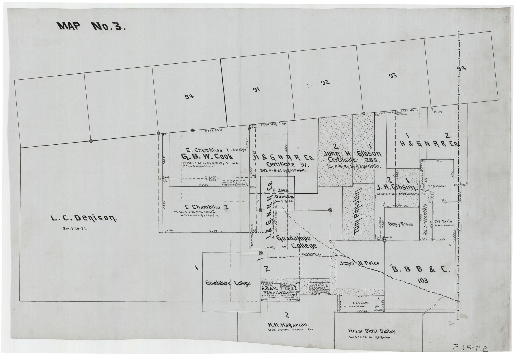
Map No. 3
215-22
-
Map/Doc
91926
-
Collection
Twichell Survey Records
-
Counties
Stephens
-
Height x Width
28.4 x 19.5 inches
72.1 x 49.5 cm
Part of: Twichell Survey Records
[Rease Price and Surrounding Surveys]
![91228, [Rease Price and Surrounding Surveys], Twichell Survey Records](https://historictexasmaps.com/wmedia_w700/maps/91228-1.tif.jpg)
Print $20.00
- Digital $50.00
[Rease Price and Surrounding Surveys]
1924
Size 18.7 x 12.7 inches
Map/Doc 91228
[South part of Bailey County showing School Leagues]
![92991, [South part of Bailey County showing School Leagues], Twichell Survey Records](https://historictexasmaps.com/wmedia_w700/maps/92991-1.tif.jpg)
Print $2.00
- Digital $50.00
[South part of Bailey County showing School Leagues]
1914
Size 5.9 x 7.6 inches
Map/Doc 92991
Cunningham Addition and Massey Heights

Print $20.00
- Digital $50.00
Cunningham Addition and Massey Heights
Size 18.9 x 24.9 inches
Map/Doc 92744
Rhyne Simpson Quirt Ave. Addition to the City of Lubbock

Print $20.00
- Digital $50.00
Rhyne Simpson Quirt Ave. Addition to the City of Lubbock
1951
Size 17.2 x 21.2 inches
Map/Doc 92878
[Sketch showing various surveys south and along Holiday Creek]
![90164, [Sketch showing various surveys south and along Holiday Creek], Twichell Survey Records](https://historictexasmaps.com/wmedia_w700/maps/90164-1.tif.jpg)
Print $20.00
- Digital $50.00
[Sketch showing various surveys south and along Holiday Creek]
Size 40.6 x 35.1 inches
Map/Doc 90164
[Blocks 34 and 35, Township 4N]
![92030, [Blocks 34 and 35, Township 4N], Twichell Survey Records](https://historictexasmaps.com/wmedia_w700/maps/92030-1.tif.jpg)
Print $20.00
- Digital $50.00
[Blocks 34 and 35, Township 4N]
Size 24.6 x 23.6 inches
Map/Doc 92030
[John Walker, south part B9 and vicinity]
![90330, [John Walker, south part B9 and vicinity], Twichell Survey Records](https://historictexasmaps.com/wmedia_w700/maps/90330-1.tif.jpg)
Print $20.00
- Digital $50.00
[John Walker, south part B9 and vicinity]
Size 32.7 x 24.1 inches
Map/Doc 90330
[Meridian thru 19th St. Muni. Standpipe]
![92864, [Meridian thru 19th St. Muni. Standpipe], Twichell Survey Records](https://historictexasmaps.com/wmedia_w700/maps/92864-1.tif.jpg)
Print $20.00
- Digital $50.00
[Meridian thru 19th St. Muni. Standpipe]
Size 23.8 x 19.5 inches
Map/Doc 92864
[Blocks Y2 and I]
![91261, [Blocks Y2 and I], Twichell Survey Records](https://historictexasmaps.com/wmedia_w700/maps/91261-1.tif.jpg)
Print $20.00
- Digital $50.00
[Blocks Y2 and I]
Size 17.8 x 13.8 inches
Map/Doc 91261
[Sketch of surveys around W.T. Brewer]
![89926, [Sketch of surveys around W.T. Brewer], Twichell Survey Records](https://historictexasmaps.com/wmedia_w700/maps/89926-1.tif.jpg)
Print $40.00
- Digital $50.00
[Sketch of surveys around W.T. Brewer]
Size 37.0 x 48.7 inches
Map/Doc 89926
[Northwest Garza Co., E. J. Powell surveys and vicinity]
![90852, [Northwest Garza Co., E. J. Powell surveys and vicinity], Twichell Survey Records](https://historictexasmaps.com/wmedia_w700/maps/90852-2.tif.jpg)
Print $2.00
- Digital $50.00
[Northwest Garza Co., E. J. Powell surveys and vicinity]
Size 8.9 x 14.2 inches
Map/Doc 90852
Working Sketch in Moore County

Print $2.00
- Digital $50.00
Working Sketch in Moore County
1909
Size 7.0 x 8.6 inches
Map/Doc 91518
You may also like
Flight Mission No. CUG-3P, Frame 143, Kleberg County

Print $20.00
- Digital $50.00
Flight Mission No. CUG-3P, Frame 143, Kleberg County
1956
Size 19.0 x 22.5 inches
Map/Doc 86278
Flight Mission No. CRE-1R, Frame 63, Jackson County

Print $20.00
- Digital $50.00
Flight Mission No. CRE-1R, Frame 63, Jackson County
1956
Size 18.6 x 18.9 inches
Map/Doc 85326
Lampasas County Sketch File 16

Print $20.00
- Digital $50.00
Lampasas County Sketch File 16
1893
Size 22.8 x 20.8 inches
Map/Doc 11976
Young County Working Sketch 23

Print $20.00
- Digital $50.00
Young County Working Sketch 23
1965
Size 31.3 x 22.3 inches
Map/Doc 62046
Gulf Intracoastal Waterway - Aransas Bay to Corpus Christi Bay - Modified Route Main Channel

Print $20.00
- Digital $50.00
Gulf Intracoastal Waterway - Aransas Bay to Corpus Christi Bay - Modified Route Main Channel
1960
Size 31.0 x 42.7 inches
Map/Doc 61901
Callahan County Sketch File 2

Print $8.00
- Digital $50.00
Callahan County Sketch File 2
1858
Size 11.8 x 8.7 inches
Map/Doc 35853
Freestone County Sketch File 5

Print $42.00
- Digital $50.00
Freestone County Sketch File 5
1854
Size 4.6 x 5.2 inches
Map/Doc 23047
Gaines County Sketch File 20

Print $12.00
- Digital $50.00
Gaines County Sketch File 20
1906
Size 7.1 x 8.9 inches
Map/Doc 23335
Cottle County Working Sketch 14a
Print $20.00
- Digital $50.00
Cottle County Working Sketch 14a
1963
Size 31.2 x 42.1 inches
Map/Doc 68324
Bexar County Working Sketch 5

Print $20.00
- Digital $50.00
Bexar County Working Sketch 5
1943
Size 25.3 x 25.0 inches
Map/Doc 67321
Fannin County Sketch File 2

Print $4.00
- Digital $50.00
Fannin County Sketch File 2
1853
Size 12.4 x 7.9 inches
Map/Doc 22445
A Map of Dallas County

Print $20.00
- Digital $50.00
A Map of Dallas County
1855
Size 18.4 x 18.8 inches
Map/Doc 3465