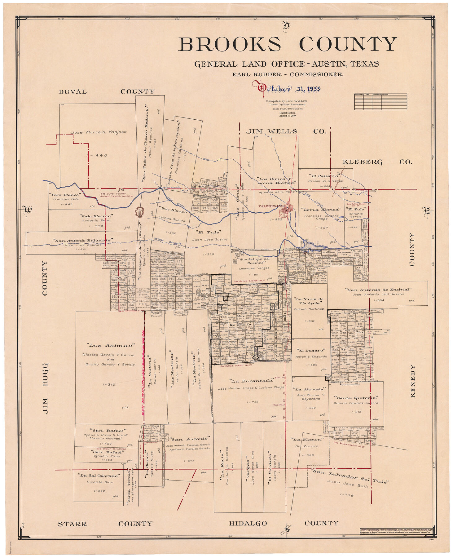
Brooks County
General Land Office Official County Map
-
Map/Doc
95440
-
Collection
General Map Collection
-
Object Dates
2019/8/31 (Revision Date)
1955/10/31 (Creation Date)
-
People and Organizations
Cheyenne Betancourt (Draftsman)
Eltea Armstrong (Draftsman)
R.C. Wisdom (Compiler)
Earl Rudder (GLO Commissioner)
-
Counties
Brooks
-
Subjects
County OCM
-
Height x Width
42.6 x 34.6 inches
108.2 x 87.9 cm
-
Medium
digital image
-
Scale
1" = 3000 varas
Part of: General Map Collection
Fisher County Sketch File 24

Print $37.00
- Digital $50.00
Fisher County Sketch File 24
1875
Size 14.3 x 8.9 inches
Map/Doc 22666
Burleson County Sketch File 8

Print $6.00
- Digital $50.00
Burleson County Sketch File 8
Size 8.7 x 5.3 inches
Map/Doc 16654

Irion County Working Sketch 13

Print $40.00
- Digital $50.00
Irion County Working Sketch 13
1968
Size 88.1 x 31.6 inches
Map/Doc 66422
Kimble County Working Sketch 11

Print $20.00
- Digital $50.00
Kimble County Working Sketch 11
1921
Size 19.0 x 25.1 inches
Map/Doc 70079
Bell County Sketch File 11

Print $4.00
- Digital $50.00
Bell County Sketch File 11
1852
Size 9.9 x 7.8 inches
Map/Doc 14383
Robertson County Working Sketch 10

Print $20.00
- Digital $50.00
Robertson County Working Sketch 10
1984
Size 20.1 x 21.6 inches
Map/Doc 63583
Cameron County Rolled Sketch 19

Print $20.00
- Digital $50.00
Cameron County Rolled Sketch 19
Size 25.8 x 23.6 inches
Map/Doc 5465
Henderson County Working Sketch 43

Print $20.00
- Digital $50.00
Henderson County Working Sketch 43
1994
Size 36.7 x 39.0 inches
Map/Doc 66176
Dawson County Sketch File 20

Print $20.00
- Digital $50.00
Dawson County Sketch File 20
1951
Size 13.2 x 21.5 inches
Map/Doc 11296
Martin County Working Sketch 9

Print $20.00
- Digital $50.00
Martin County Working Sketch 9
1971
Size 45.2 x 38.1 inches
Map/Doc 70827
Yoakum County Sketch File 10b

Print $20.00
- Digital $50.00
Yoakum County Sketch File 10b
Size 22.4 x 15.8 inches
Map/Doc 12707
You may also like
[Texas and Pacific Railroad Co. Blocks 55, 54 and 76, Townships 1 & 2]
![89882, [Texas and Pacific Railroad Co. Blocks 55, 54 and 76, Townships 1 & 2], Twichell Survey Records](https://historictexasmaps.com/wmedia_w700/maps/89882-1.tif.jpg)
Print $20.00
- Digital $50.00
[Texas and Pacific Railroad Co. Blocks 55, 54 and 76, Townships 1 & 2]
Size 46.2 x 41.5 inches
Map/Doc 89882
Southern Pacific R.R. and connections

Print $20.00
- Digital $50.00
Southern Pacific R.R. and connections
1883
Size 27.9 x 32.5 inches
Map/Doc 94270
Louisiana and Texas Intracoastal Waterway, Sabine River Galveston Bay Section Survey

Print $20.00
- Digital $50.00
Louisiana and Texas Intracoastal Waterway, Sabine River Galveston Bay Section Survey
1927
Size 30.7 x 43.0 inches
Map/Doc 61838
Leon County Sketch File 2

Print $4.00
- Digital $50.00
Leon County Sketch File 2
1852
Size 8.1 x 5.1 inches
Map/Doc 29711
Flight Mission No. DAH-9M, Frame 199, Orange County

Print $20.00
- Digital $50.00
Flight Mission No. DAH-9M, Frame 199, Orange County
1953
Size 18.6 x 22.5 inches
Map/Doc 86867
Oldham County

Print $40.00
- Digital $50.00
Oldham County
1925
Size 40.5 x 52.1 inches
Map/Doc 73254
McMullen County Working Sketch 17

Print $20.00
- Digital $50.00
McMullen County Working Sketch 17
1941
Size 35.1 x 21.8 inches
Map/Doc 70718
Presidio County Working Sketch 25

Print $20.00
- Digital $50.00
Presidio County Working Sketch 25
1945
Size 22.8 x 18.9 inches
Map/Doc 71701
Upton County Working Sketch 20

Print $40.00
- Digital $50.00
Upton County Working Sketch 20
1950
Size 52.8 x 42.1 inches
Map/Doc 69516
[Sketch for Mineral Application 24072, San Jacinto River]
![65609, [Sketch for Mineral Application 24072, San Jacinto River], General Map Collection](https://historictexasmaps.com/wmedia_w700/maps/65609.tif.jpg)
Print $20.00
- Digital $50.00
[Sketch for Mineral Application 24072, San Jacinto River]
1929
Size 8.4 x 13.9 inches
Map/Doc 65609
[Townships 1 & 2, Blocks 53, 54, 55, and 76]
![92882, [Townships 1 & 2, Blocks 53, 54, 55, and 76], Twichell Survey Records](https://historictexasmaps.com/wmedia_w700/maps/92882-1.tif.jpg)
Print $20.00
- Digital $50.00
[Townships 1 & 2, Blocks 53, 54, 55, and 76]
Size 29.3 x 24.0 inches
Map/Doc 92882
Panola County Sketch File 2

Print $4.00
- Digital $50.00
Panola County Sketch File 2
1851
Size 10.8 x 8.2 inches
Map/Doc 33447