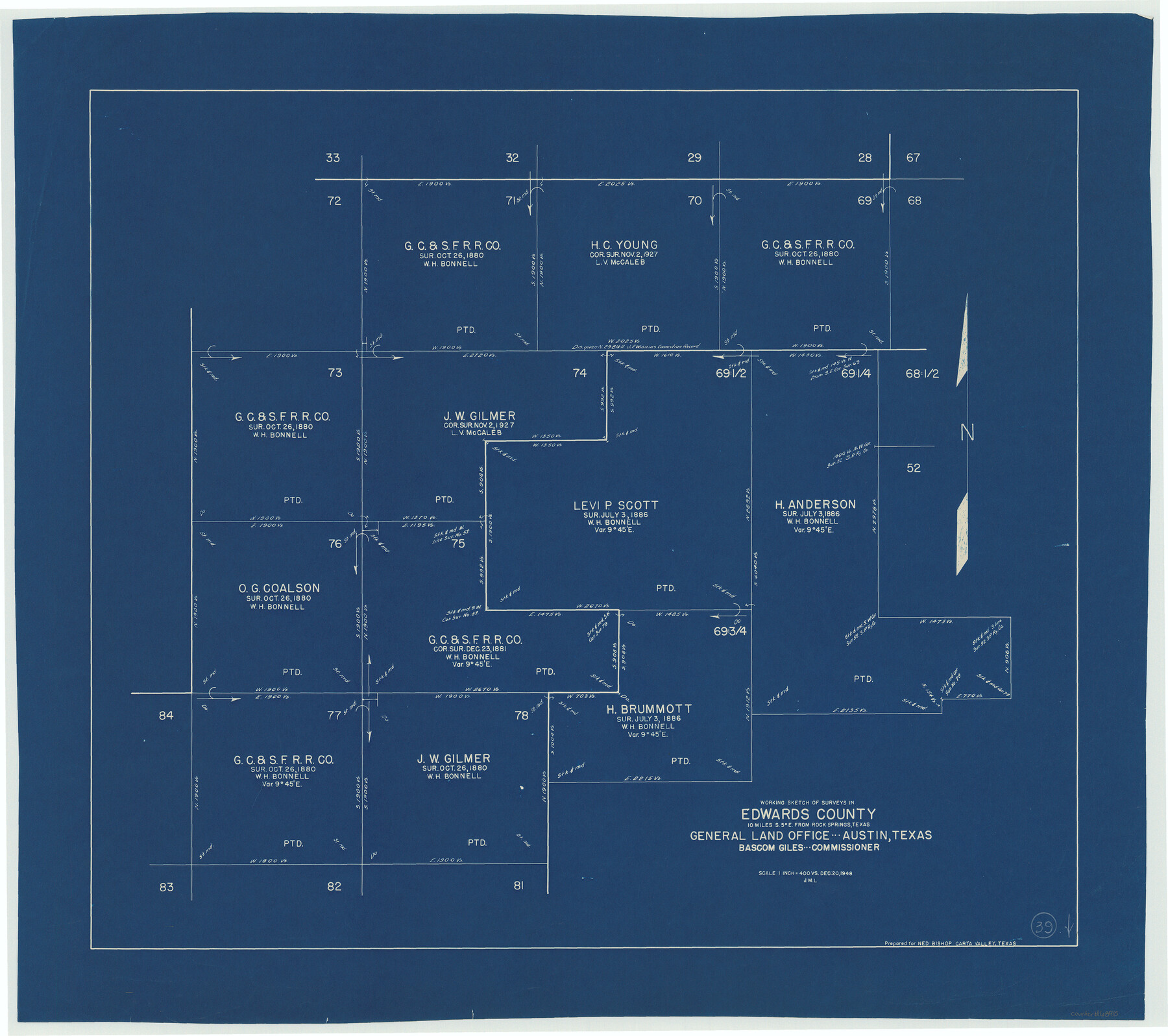
Edwards County Working Sketch 39
-
Map/Doc
68915
-
Collection
General Map Collection
-
Object Dates
12/20/1948 (Creation Date)
-
Counties
Edwards
-
Subjects
Surveying Working Sketch
-
Height x Width
28.7 x 32.3 inches
72.9 x 82.0 cm
-
Scale
1" = 400 varas
Part of: General Map Collection
Runnels County Working Sketch 13

Print $20.00
- Digital $50.00
Runnels County Working Sketch 13
1950
Size 19.4 x 17.8 inches
Map/Doc 63609
Surveys East of Cedar Lake

Print $20.00
- Digital $50.00
Surveys East of Cedar Lake
1824
Size 13.3 x 20.9 inches
Map/Doc 210
Flight Mission No. BRA-7M, Frame 83, Jefferson County

Print $20.00
- Digital $50.00
Flight Mission No. BRA-7M, Frame 83, Jefferson County
1953
Size 16.1 x 16.1 inches
Map/Doc 85505
San Saba County Rolled Sketch 2

Print $20.00
- Digital $50.00
San Saba County Rolled Sketch 2
Size 38.9 x 20.7 inches
Map/Doc 7743
Flight Mission No. CUG-3P, Frame 16, Kleberg County

Print $20.00
- Digital $50.00
Flight Mission No. CUG-3P, Frame 16, Kleberg County
1956
Size 18.3 x 22.2 inches
Map/Doc 86226
[Sketch for Mineral Application 17237 / Mineral File 11855 - Neches River, Joe A. Sanders]
![2819, [Sketch for Mineral Application 17237 / Mineral File 11855 - Neches River, Joe A. Sanders], General Map Collection](https://historictexasmaps.com/wmedia_w700/maps/2819.tif.jpg)
Print $2.00
- Digital $50.00
[Sketch for Mineral Application 17237 / Mineral File 11855 - Neches River, Joe A. Sanders]
1927
Size 12.8 x 8.2 inches
Map/Doc 2819
Jeff Davis Co.

Print $40.00
- Digital $50.00
Jeff Davis Co.
1915
Size 30.4 x 52.2 inches
Map/Doc 66881
Hardin County Sketch File 67

Print $10.00
- Digital $50.00
Hardin County Sketch File 67
Size 11.4 x 8.9 inches
Map/Doc 25252
Wilson County Sketch File 3b

Print $22.00
- Digital $50.00
Wilson County Sketch File 3b
Size 7.8 x 11.9 inches
Map/Doc 40402
Map of Mason County

Print $20.00
- Digital $50.00
Map of Mason County
1859
Size 28.4 x 22.4 inches
Map/Doc 3838
Terrell County Working Sketch 19

Print $20.00
- Digital $50.00
Terrell County Working Sketch 19
1932
Size 18.6 x 25.6 inches
Map/Doc 69801
Flight Mission No. CGI-1N, Frame 215, Cameron County

Print $20.00
- Digital $50.00
Flight Mission No. CGI-1N, Frame 215, Cameron County
1955
Size 18.5 x 22.1 inches
Map/Doc 84524
You may also like
Medina County Working Sketch 6

Print $20.00
- Digital $50.00
Medina County Working Sketch 6
1950
Size 20.7 x 21.3 inches
Map/Doc 70921
Survey plat of lots 2, 4, 6, 8, 10-16, Block 322 of the original town site of Jourdanton known as School File 154507

Print $4.00
- Digital $50.00
Survey plat of lots 2, 4, 6, 8, 10-16, Block 322 of the original town site of Jourdanton known as School File 154507
2001
Size 26.0 x 27.7 inches
Map/Doc 60392
Coleman County Working Sketch Graphic Index

Print $40.00
- Digital $50.00
Coleman County Working Sketch Graphic Index
1945
Size 54.0 x 36.3 inches
Map/Doc 76497
Portion of States Submerged Area in Matagorda Bay

Print $20.00
- Digital $50.00
Portion of States Submerged Area in Matagorda Bay
1921
Size 15.7 x 15.1 inches
Map/Doc 2950
Childress County Rolled Sketch 18A

Print $20.00
- Digital $50.00
Childress County Rolled Sketch 18A
1913
Size 18.5 x 39.8 inches
Map/Doc 5452
Clay County Boundary File 16

Print $56.00
- Digital $50.00
Clay County Boundary File 16
Size 9.1 x 3.7 inches
Map/Doc 51422
[Nueces Bay Islands and Nesting Birds]
![60312, [Nueces Bay Islands and Nesting Birds], General Map Collection](https://historictexasmaps.com/wmedia_w700/maps/60312.tif.jpg)
Print $2.00
- Digital $50.00
[Nueces Bay Islands and Nesting Birds]
1940
Size 11.4 x 7.2 inches
Map/Doc 60312
Robertson County Working Sketch 17

Print $20.00
- Digital $50.00
Robertson County Working Sketch 17
1991
Size 16.8 x 22.9 inches
Map/Doc 63590
University Land Field Notes for Blocks 1, 2, 3, 4, 5, 8, 9, and 10 in Andrews County, Block 6 in Andrews, Dawson, Gaines, and Martin Counties, and Block 7 in Andrews and Martin Counties

University Land Field Notes for Blocks 1, 2, 3, 4, 5, 8, 9, and 10 in Andrews County, Block 6 in Andrews, Dawson, Gaines, and Martin Counties, and Block 7 in Andrews and Martin Counties
Map/Doc 81710
Flight Mission No. CRK-7P, Frame 79, Refugio County

Print $20.00
- Digital $50.00
Flight Mission No. CRK-7P, Frame 79, Refugio County
1956
Size 18.2 x 22.1 inches
Map/Doc 86950
[Sketch for Mineral Application 13439 - Bed Lost Lake, Walle Merritt]
![65578, [Sketch for Mineral Application 13439 - Bed Lost Lake, Walle Merritt], General Map Collection](https://historictexasmaps.com/wmedia_w700/maps/65578.tif.jpg)
Print $20.00
- Digital $50.00
[Sketch for Mineral Application 13439 - Bed Lost Lake, Walle Merritt]
1925
Size 31.0 x 29.6 inches
Map/Doc 65578
Stephens County Working Sketch 11

Print $20.00
- Digital $50.00
Stephens County Working Sketch 11
1921
Size 21.0 x 16.5 inches
Map/Doc 63954