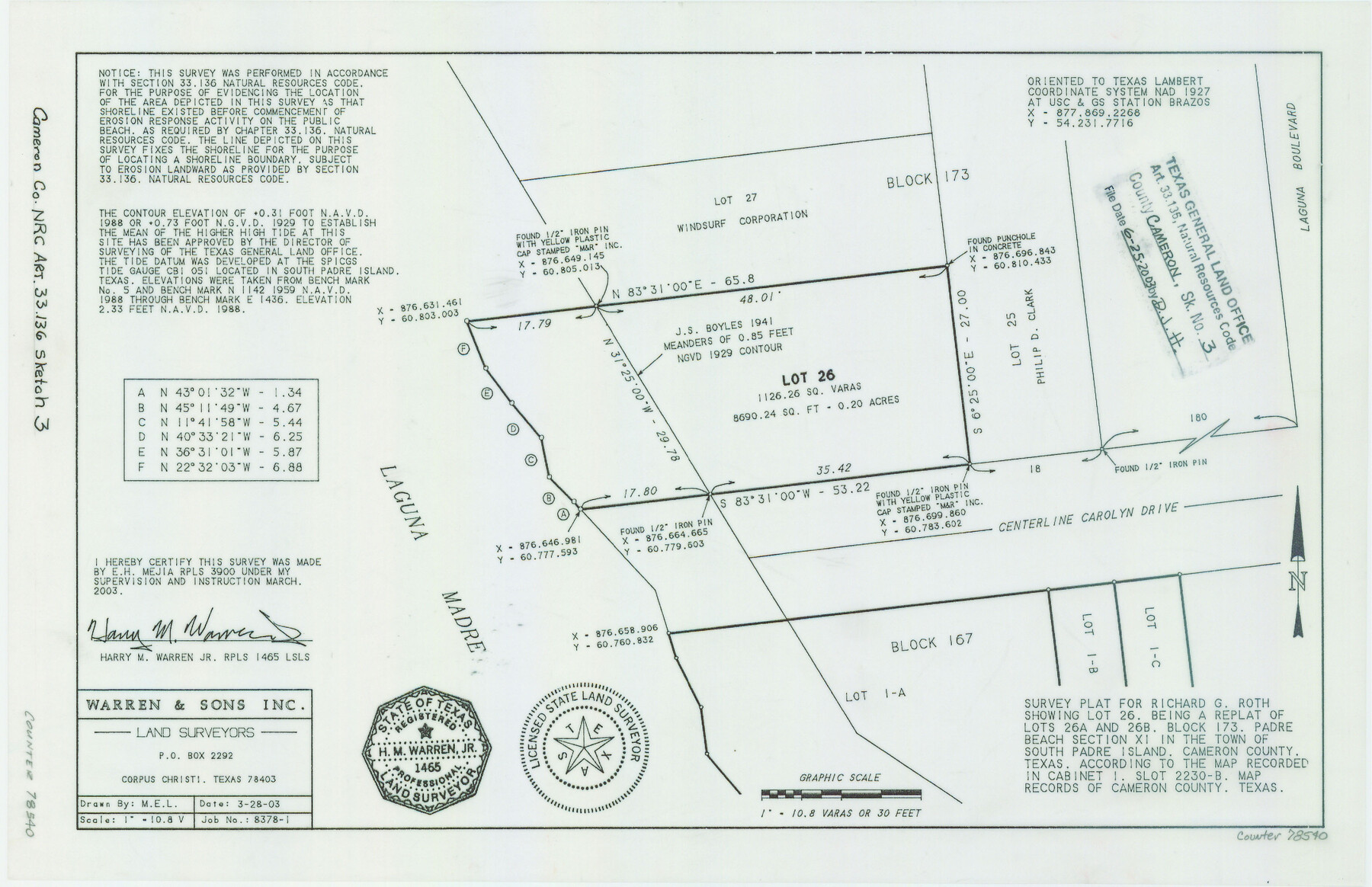
Cameron County NRC Article 33.136 Sketch 3
Survey Plat Being a Replat of Lots 26A and 26B, Block 173, Padre Beach Section XI, South Padre Island
-
Map/Doc
78540
-
Collection
General Map Collection
-
Object Dates
2003/3/28 (Creation Date)
2003/6/25 (File Date)
-
People and Organizations
Warren & Sons, Inc. (Publisher)
Warren & Sons, Inc. (Printer)
Harry M. Warren Jr. (Surveyor/Engineer)
M.E.L. (Draftsman)
-
Counties
Cameron
-
Subjects
Surveying CBS
-
Height x Width
11.2 x 17.3 inches
28.4 x 43.9 cm
-
Medium
multi-page, multi-format
-
Comments
Survey located 21 miles North 52 degrees East of Brownsville, Texas.
One or more items in this file were formerly filed in another file. They have been reunited in this file with their original grouping. The old name on these sheets has been crossed
Part of: General Map Collection
Flight Mission No. CUI-1H, Frame 95, Milam County

Print $20.00
- Digital $50.00
Flight Mission No. CUI-1H, Frame 95, Milam County
1951
Size 18.4 x 22.2 inches
Map/Doc 86603
Menard County Rolled Sketch 6

Print $20.00
- Digital $50.00
Menard County Rolled Sketch 6
Size 17.3 x 21.2 inches
Map/Doc 6755
Jackson County Sketch File 16

Print $10.00
- Digital $50.00
Jackson County Sketch File 16
1913
Size 14.3 x 8.7 inches
Map/Doc 27668
Flight Mission No. CRC-3R, Frame 10, Chambers County

Print $20.00
- Digital $50.00
Flight Mission No. CRC-3R, Frame 10, Chambers County
1956
Size 18.5 x 22.2 inches
Map/Doc 84784
Controlled Mosaic by Jack Amman Photogrammetric Engineers, Inc - Sheet 1

Print $20.00
- Digital $50.00
Controlled Mosaic by Jack Amman Photogrammetric Engineers, Inc - Sheet 1
1954
Size 20.0 x 24.0 inches
Map/Doc 83445
Crockett County Working Sketch 45

Print $20.00
- Digital $50.00
Crockett County Working Sketch 45
1933
Size 33.7 x 26.8 inches
Map/Doc 68378
Flight Mission No. DCL-5C, Frame 29, Kenedy County

Print $20.00
- Digital $50.00
Flight Mission No. DCL-5C, Frame 29, Kenedy County
1943
Size 18.4 x 22.4 inches
Map/Doc 85841
Lamar County Boundary File 56

Print $60.00
- Digital $50.00
Lamar County Boundary File 56
Size 8.7 x 6.4 inches
Map/Doc 56000
Pecos County Rolled Sketch 91

Print $20.00
- Digital $50.00
Pecos County Rolled Sketch 91
Size 23.6 x 34.7 inches
Map/Doc 9710

Flight Mission No. BQR-16K, Frame 37, Brazoria County

Print $20.00
- Digital $50.00
Flight Mission No. BQR-16K, Frame 37, Brazoria County
1952
Size 18.6 x 22.3 inches
Map/Doc 84104
Archer County Sketch File 5

Print $4.00
- Digital $50.00
Archer County Sketch File 5
1858
Size 7.8 x 8.7 inches
Map/Doc 13632
You may also like
Tom Green County Rolled Sketch 15

Print $20.00
- Digital $50.00
Tom Green County Rolled Sketch 15
Size 38.7 x 43.1 inches
Map/Doc 10002
Sketch of Surveys in Crosby and Garza Cos.

Print $20.00
- Digital $50.00
Sketch of Surveys in Crosby and Garza Cos.
Size 19.7 x 25.3 inches
Map/Doc 90338
Green & Lumsden's Ranch

Print $20.00
- Digital $50.00
Green & Lumsden's Ranch
Size 28.9 x 25.1 inches
Map/Doc 92946
Map of Bowie County

Print $20.00
- Digital $50.00
Map of Bowie County
1884
Size 19.4 x 23.7 inches
Map/Doc 3319
Travis County Rolled Sketch 27

Print $20.00
- Digital $50.00
Travis County Rolled Sketch 27
1945
Size 23.5 x 17.8 inches
Map/Doc 8029
Chambers County Sketch File 54

Print $3.00
- Digital $50.00
Chambers County Sketch File 54
1895
Size 16.5 x 10.3 inches
Map/Doc 18093
Travis County State Real Property Sketch 7

Print $20.00
- Digital $50.00
Travis County State Real Property Sketch 7
1985
Size 30.9 x 43.4 inches
Map/Doc 61699
Map of DeWitt County

Print $20.00
- Digital $50.00
Map of DeWitt County
1853
Size 21.5 x 25.5 inches
Map/Doc 3479
Aransas County Working Sketch 13

Print $20.00
- Digital $50.00
Aransas County Working Sketch 13
1950
Size 26.0 x 42.2 inches
Map/Doc 67180
Survey of the Mexican Lines of Defence at Cerro Gordo, and the lines of attack of the American Army under Major General Scott, on the 17th and 18th of April, 1847

Print $20.00
- Digital $50.00
Survey of the Mexican Lines of Defence at Cerro Gordo, and the lines of attack of the American Army under Major General Scott, on the 17th and 18th of April, 1847
1847
Size 15.3 x 21.6 inches
Map/Doc 95830
Upshur County Working Sketch 1

Print $20.00
- Digital $50.00
Upshur County Working Sketch 1
1934
Size 28.9 x 32.6 inches
Map/Doc 69557
Cooke County Sketch File 16-17-18

Print $16.00
- Digital $50.00
Cooke County Sketch File 16-17-18
1860
Size 12.7 x 8.1 inches
Map/Doc 19252