Jackson County Sketch File 16
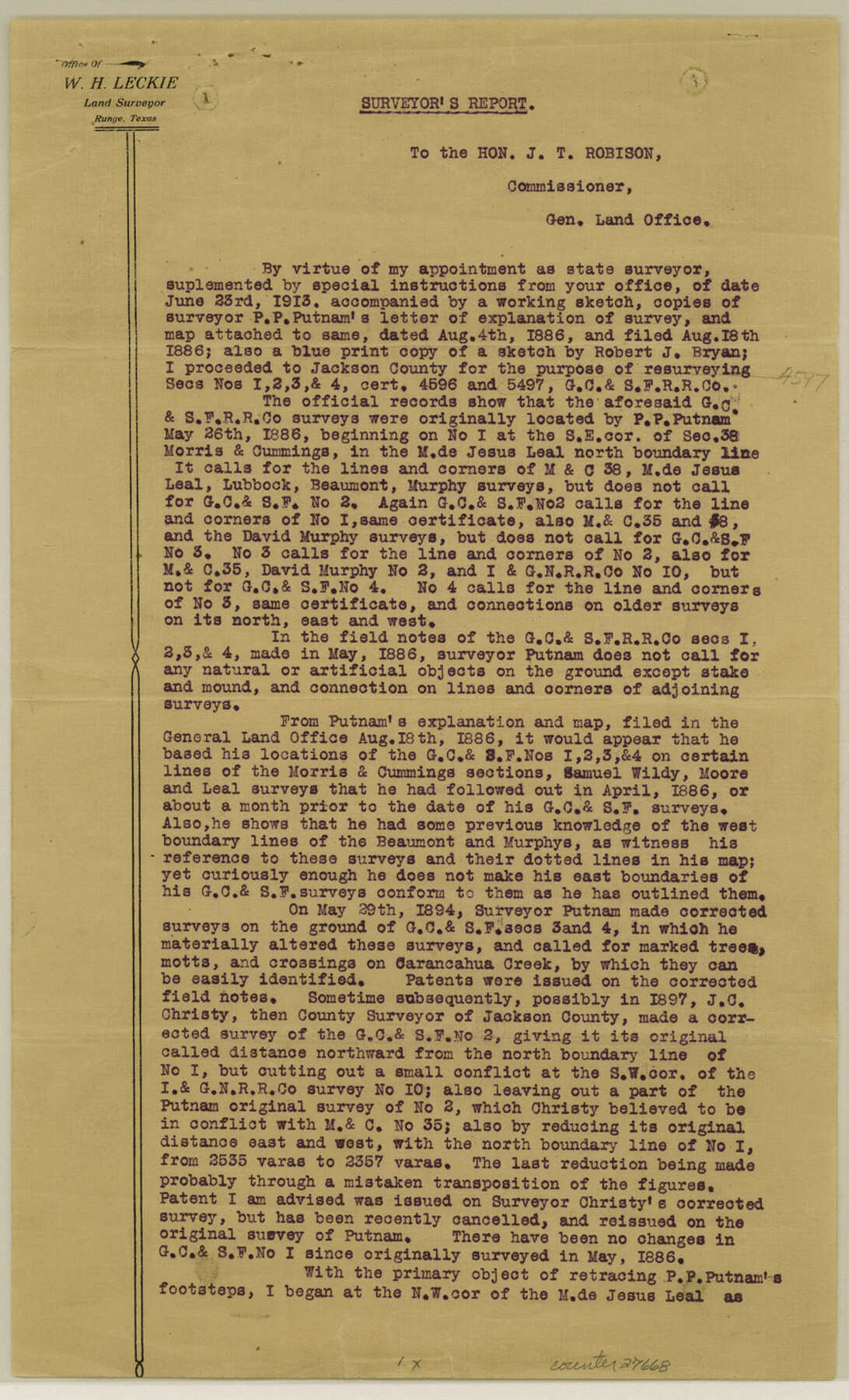
[Report on resurvey of surveys 1, 2, 3, & 4, G. C. & S. F. Ry. Co.]
-
Map/Doc
27668
-
Collection
General Map Collection
-
Object Dates
1913/7/25 (Creation Date)
1913/9/9 (File Date)
1886/8/18 (File Date)
1886/5/26 (Survey Date)
1894/5/29 (Survey Date)
1886 (Survey Date)
1894/7/13 (Survey Date)
-
People and Organizations
Wm. H. Leckie (Surveyor/Engineer)
Robert J. Bryan (Draftsman)
P.P. Putnam (Surveyor/Engineer)
J.C. Christy (Surveyor/Engineer)
Fred S. Robbins (Surveyor/Engineer)
-
Counties
Jackson Matagorda
-
Subjects
Surveying Sketch File
-
Height x Width
14.3 x 8.7 inches
36.3 x 22.1 cm
-
Medium
paper, print
-
Comments
See Jackson County Rolled Sketch 3 (6336), Jackson County Rolled Sketch 3A (6337), Jackson County Rolled Sketch 3B (6338), and Jackson County Rolled Sketch 3C (6339).
-
Features
Carancahua Creek
East Carancahua Creek
Related maps
Jackson County Rolled Sketch 3

Print $20.00
- Digital $50.00
Jackson County Rolled Sketch 3
1913
Size 23.9 x 24.2 inches
Map/Doc 6336
Jackson County Rolled Sketch 3A

Print $20.00
- Digital $50.00
Jackson County Rolled Sketch 3A
1913
Size 23.2 x 22.6 inches
Map/Doc 6337
Jackson County Rolled Sketch 3B

Print $20.00
- Digital $50.00
Jackson County Rolled Sketch 3B
1913
Size 23.7 x 21.8 inches
Map/Doc 6338
Jackson County Rolled Sketch 3C

Print $59.00
- Digital $50.00
Jackson County Rolled Sketch 3C
1913
Size 23.7 x 21.8 inches
Map/Doc 6339
Part of: General Map Collection

Ward County Working Sketch 35

Print $20.00
- Digital $50.00
Ward County Working Sketch 35
1968
Size 46.4 x 43.0 inches
Map/Doc 72341
Map of Victoria County

Print $20.00
- Digital $50.00
Map of Victoria County
1873
Size 20.9 x 19.3 inches
Map/Doc 4639
Glasscock County Rolled Sketch 4

Print $20.00
- Digital $50.00
Glasscock County Rolled Sketch 4
1928
Size 26.7 x 20.9 inches
Map/Doc 6015
Upshur County Sketch File 7

Print $4.00
- Digital $50.00
Upshur County Sketch File 7
1849
Size 8.2 x 10.2 inches
Map/Doc 38744
Hutchinson County Sketch File 33

Print $20.00
- Digital $50.00
Hutchinson County Sketch File 33
1926
Size 26.5 x 24.5 inches
Map/Doc 11821
Lavaca County Sketch File 6

Print $2.00
- Digital $50.00
Lavaca County Sketch File 6
Size 7.3 x 3.2 inches
Map/Doc 29641
Uvalde County Working Sketch 66

Print $20.00
- Digital $50.00
Uvalde County Working Sketch 66
1942
Size 20.9 x 21.3 inches
Map/Doc 75968
Duval County Rolled Sketch 37

Print $20.00
- Digital $50.00
Duval County Rolled Sketch 37
1952
Size 29.2 x 24.6 inches
Map/Doc 5753

Potter County Boundary File 4b

Print $20.00
- Digital $50.00
Potter County Boundary File 4b
Size 9.2 x 32.9 inches
Map/Doc 58012
Austin County Sketch File 6b

Print $50.00
- Digital $50.00
Austin County Sketch File 6b
1894
Size 11.3 x 8.6 inches
Map/Doc 13872
You may also like
Jim Hogg County Rolled Sketch EJ

Print $40.00
- Digital $50.00
Jim Hogg County Rolled Sketch EJ
1933
Size 50.7 x 37.0 inches
Map/Doc 9321
Pecos County Working Sketch 106

Print $40.00
- Digital $50.00
Pecos County Working Sketch 106
1971
Size 64.9 x 38.1 inches
Map/Doc 71579
Official Highway Map of Texas

Print $20.00
Official Highway Map of Texas
1926
Size 25.0 x 24.9 inches
Map/Doc 79744
Atlantic Coast to the Rocky Mountains

Atlantic Coast to the Rocky Mountains
1956
Size 42.5 x 29.4 inches
Map/Doc 94409
Liberty County Sketch File 2

Print $2.00
- Digital $50.00
Liberty County Sketch File 2
Size 7.7 x 3.3 inches
Map/Doc 29883
Kent County Boundary File 4a

Print $18.00
- Digital $50.00
Kent County Boundary File 4a
Size 14.2 x 8.5 inches
Map/Doc 55838
Flight Mission No. BRA-3M, Frame 197, Jefferson County

Print $20.00
- Digital $50.00
Flight Mission No. BRA-3M, Frame 197, Jefferson County
1953
Size 18.6 x 22.4 inches
Map/Doc 85412
Terry County Rolled Sketch 4

Print $20.00
- Digital $50.00
Terry County Rolled Sketch 4
Size 38.7 x 36.8 inches
Map/Doc 9994
Map of Burnet Co.

Print $20.00
- Digital $50.00
Map of Burnet Co.
1887
Size 45.5 x 37.9 inches
Map/Doc 7816

Crockett County Sketch File A

Print $40.00
- Digital $50.00
Crockett County Sketch File A
Size 21.9 x 7.5 inches
Map/Doc 19624
Atascosa County

Print $20.00
- Digital $50.00
Atascosa County
1948
Size 47.6 x 44.9 inches
Map/Doc 77204