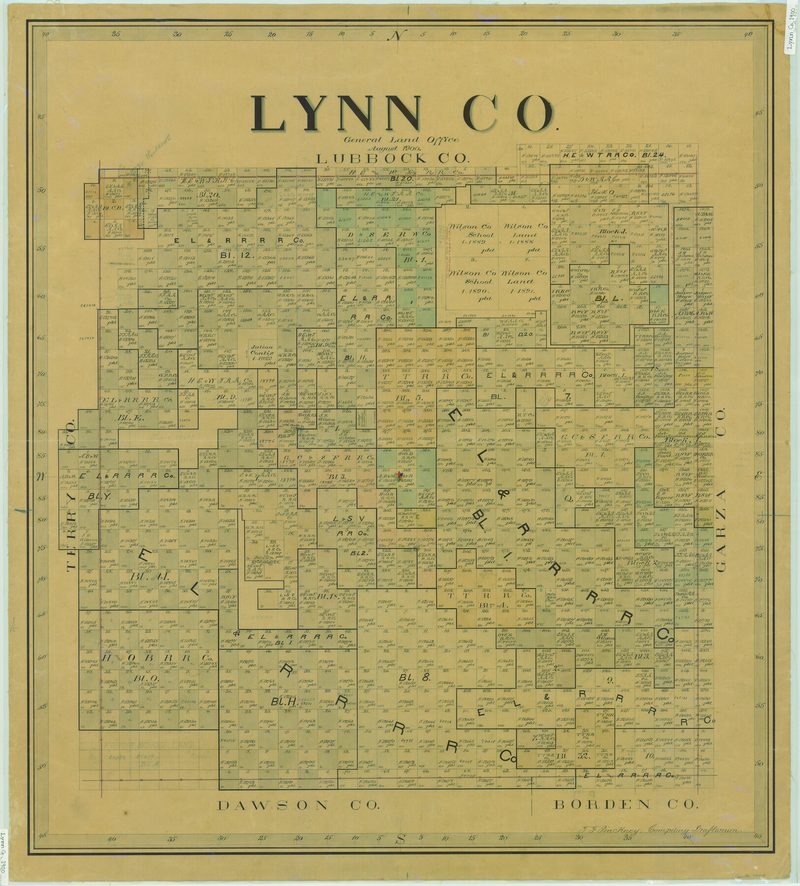
Lynn Co.
-
Map/Doc
78419
-
Collection
General Map Collection
-
Object Dates
1900 (Creation Date)
-
People and Organizations
Texas General Land Office (Publisher)
Theo. F. Pinckney (Compiler)
Theo. F. Pinckney (Draftsman)
-
Counties
Lynn
-
Subjects
County
-
Height x Width
42.1 x 38.0 inches
106.9 x 96.5 cm
-
Comments
Help Save Texas History - Adopt Me!
-
Features
Double Lakes
Twin Lakes
Dew Drop Lake
Part of: General Map Collection

Culberson County Sketch File EM and RJ

Print $24.00
- Digital $50.00
Culberson County Sketch File EM and RJ
Size 13.3 x 8.8 inches
Map/Doc 20157
Jim Wells County Working Sketch 11

Print $20.00
- Digital $50.00
Jim Wells County Working Sketch 11
1953
Size 20.4 x 22.6 inches
Map/Doc 66609
Pecos County Rolled Sketch JAS-1A

Print $40.00
- Digital $50.00
Pecos County Rolled Sketch JAS-1A
1960
Size 43.5 x 63.3 inches
Map/Doc 9746
Williamson County State Real Property Sketch 1

Print $20.00
- Digital $50.00
Williamson County State Real Property Sketch 1
1985
Size 46.1 x 36.2 inches
Map/Doc 61692
Bandera County Working Sketch 41

Print $20.00
- Digital $50.00
Bandera County Working Sketch 41
1977
Size 31.3 x 37.7 inches
Map/Doc 67637
Gillespie County

Print $40.00
- Digital $50.00
Gillespie County
1887
Size 44.1 x 59.7 inches
Map/Doc 16835
Harris County Working Sketch 72

Print $20.00
- Digital $50.00
Harris County Working Sketch 72
1958
Size 24.9 x 43.6 inches
Map/Doc 65964
Colorado River, Danevang Sheet

Print $6.00
- Digital $50.00
Colorado River, Danevang Sheet
1940
Size 24.6 x 35.2 inches
Map/Doc 65321
Topographical Map for Commerce of Dallas, Texas

Print $20.00
- Digital $50.00
Topographical Map for Commerce of Dallas, Texas
1890
Size 26.3 x 20.6 inches
Map/Doc 96792
Fort Bend County Sketch File 24

Print $20.00
- Digital $50.00
Fort Bend County Sketch File 24
1890
Size 23.5 x 32.4 inches
Map/Doc 11509
PSL Field Notes for Blocks 110 through 122 in Culberson County and Block 123 in Hudspeth County

PSL Field Notes for Blocks 110 through 122 in Culberson County and Block 123 in Hudspeth County
Map/Doc 81666
You may also like
Refugio County Rolled Sketch 5

Print $20.00
- Digital $50.00
Refugio County Rolled Sketch 5
1941
Size 45.0 x 42.5 inches
Map/Doc 9859
Freestone County Working Sketch 9

Print $20.00
- Digital $50.00
Freestone County Working Sketch 9
1975
Size 26.3 x 38.4 inches
Map/Doc 69251
Laguna Madre from Rainy Triangulation Station to Mosquito Triangulation Station

Print $40.00
- Digital $50.00
Laguna Madre from Rainy Triangulation Station to Mosquito Triangulation Station
1881
Size 31.4 x 53.7 inches
Map/Doc 73490
Irion County Sketch File 18

Print $10.00
- Digital $50.00
Irion County Sketch File 18
Size 11.2 x 8.7 inches
Map/Doc 27494
Starr County Working Sketch 20

Print $20.00
- Digital $50.00
Starr County Working Sketch 20
1982
Size 29.5 x 35.2 inches
Map/Doc 63936
Hamilton County

Print $20.00
- Digital $50.00
Hamilton County
1876
Size 24.4 x 26.2 inches
Map/Doc 3622
Kimble County Working Sketch 66

Print $20.00
- Digital $50.00
Kimble County Working Sketch 66
1965
Size 31.1 x 27.2 inches
Map/Doc 70134
Flight Mission No. DAG-14K, Frame 143, Matagorda County

Print $20.00
- Digital $50.00
Flight Mission No. DAG-14K, Frame 143, Matagorda County
1952
Size 16.4 x 16.4 inches
Map/Doc 86310
Nolan County Sketch File 3

Print $20.00
- Digital $50.00
Nolan County Sketch File 3
Size 8.0 x 36.6 inches
Map/Doc 42161
Outer Continental Shelf Leasing Maps (Texas Offshore Operations)

Print $20.00
- Digital $50.00
Outer Continental Shelf Leasing Maps (Texas Offshore Operations)
1954
Size 20.3 x 15.5 inches
Map/Doc 75839
Montgomery County Rolled Sketch 43

Print $20.00
- Digital $50.00
Montgomery County Rolled Sketch 43
1971
Size 32.1 x 34.3 inches
Map/Doc 6822
Gulf Oil Corp. Fishgide - Freeport

Gulf Oil Corp. Fishgide - Freeport
1960
Size 12.1 x 22.1 inches
Map/Doc 75979