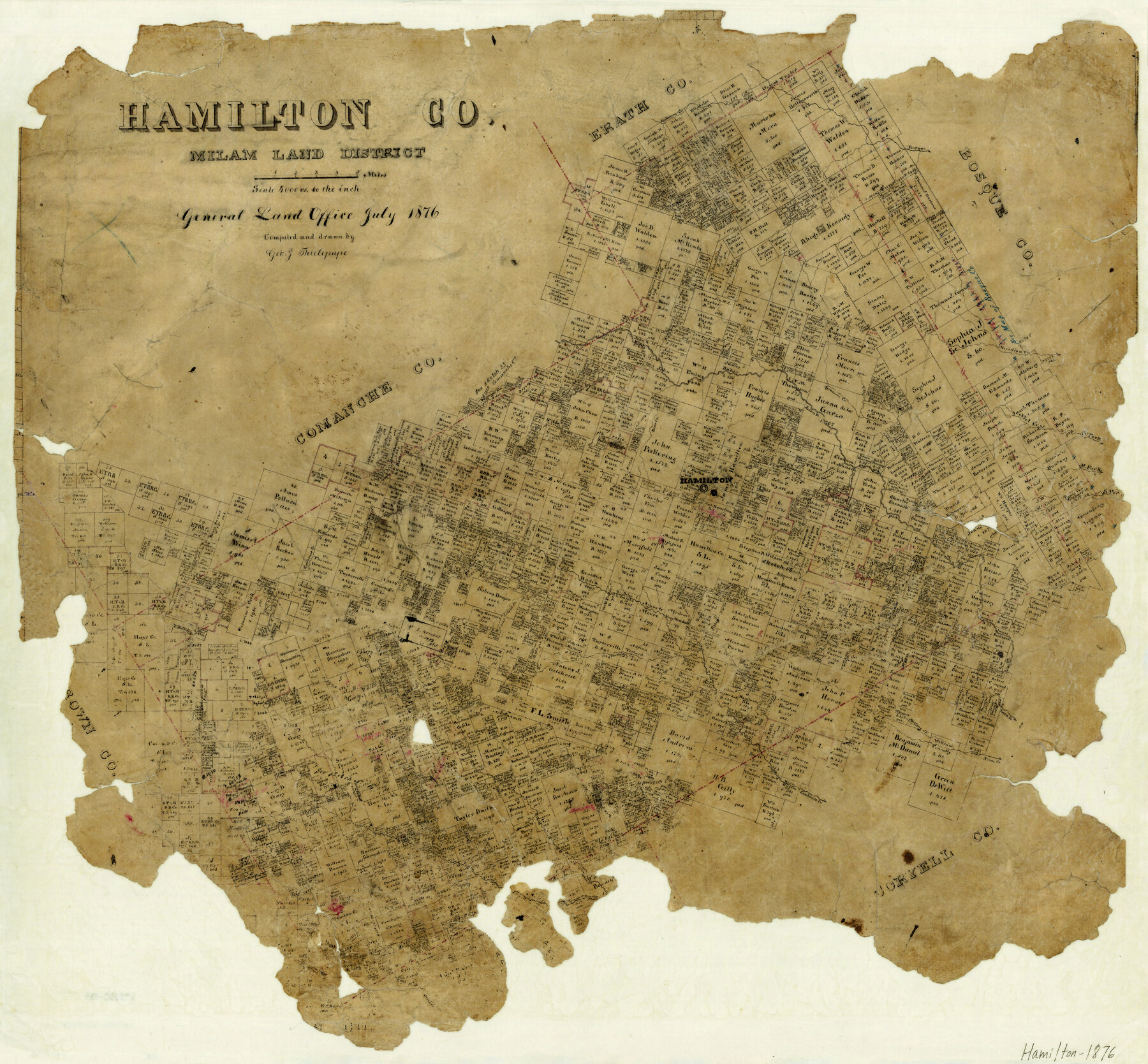
Hamilton County
-
Map/Doc
3622
-
Collection
General Map Collection
-
Object Dates
7/1876 (Creation Date)
-
People and Organizations
George J. Thielepape (Draftsman)
-
Counties
Hamilton
-
Subjects
County
-
Height x Width
24.4 x 26.2 inches
62.0 x 66.6 cm
-
Features
Cowhouse [sic] Creek
South Bennett Creek
Lampasas River
Middle Cowhouse [sic] Creek
Avana Creek
Block Creek
South Fork [of Niel Creek]
Middle Fork [of Niel Creek]
North Fork of Niel Creek
Mesquite Creek
Mustang Creek
Plum Creek
Partridge Creek
Collard Creek
Gillmore Creek
Gholson Creek
Meridian Creek
Niel Creek
Alexander Creek
Egg Creek
Sycamore Creek
Pecan Creek
Comanche Creek
Leon River
Hamilton
Bear Creek
Warrings Creek
Bosque Creek
Part of: General Map Collection
San Patricio County Sketch File 10

Print $8.00
San Patricio County Sketch File 10
1847
Size 13.3 x 8.4 inches
Map/Doc 36040
Baylor County Working Sketch 1

Print $20.00
- Digital $50.00
Baylor County Working Sketch 1
1912
Size 19.9 x 12.7 inches
Map/Doc 67286
Tyler County Sketch File 18

Print $4.00
- Digital $50.00
Tyler County Sketch File 18
1879
Size 8.2 x 8.7 inches
Map/Doc 38668
Franklin County Sketch File 17

Print $16.00
- Digital $50.00
Franklin County Sketch File 17
1951
Size 11.3 x 8.8 inches
Map/Doc 23026
Flight Mission No. DAG-14K, Frame 42, Matagorda County

Print $20.00
- Digital $50.00
Flight Mission No. DAG-14K, Frame 42, Matagorda County
1952
Size 18.5 x 22.3 inches
Map/Doc 86300
Montgomery County Rolled Sketch 42

Print $20.00
- Digital $50.00
Montgomery County Rolled Sketch 42
1939
Size 14.1 x 20.1 inches
Map/Doc 6818
Dawson County Boundary File 3 (1)

Print $40.00
- Digital $50.00
Dawson County Boundary File 3 (1)
Size 11.1 x 35.8 inches
Map/Doc 52365
Eastland County Working Sketch 62

Print $20.00
- Digital $50.00
Eastland County Working Sketch 62
1989
Size 20.7 x 28.0 inches
Map/Doc 68843
Jasper County Sketch File 27

Print $22.00
- Digital $50.00
Jasper County Sketch File 27
Size 11.4 x 8.8 inches
Map/Doc 27842
Taylor County Sketch File 5

Print $4.00
- Digital $50.00
Taylor County Sketch File 5
Size 9.3 x 7.8 inches
Map/Doc 37781
Jeff Davis County Rolled Sketch 24

Print $20.00
- Digital $50.00
Jeff Davis County Rolled Sketch 24
1953
Size 23.2 x 32.5 inches
Map/Doc 6372
United States - Gulf Coast - From Latitude 26° 33' to the Rio Grande Texas

Print $20.00
- Digital $50.00
United States - Gulf Coast - From Latitude 26° 33' to the Rio Grande Texas
1913
Size 28.0 x 18.2 inches
Map/Doc 72833
You may also like
Comanche County Working Sketch 5

Print $20.00
- Digital $50.00
Comanche County Working Sketch 5
1919
Size 31.8 x 28.9 inches
Map/Doc 68139
Zavala County

Print $40.00
- Digital $50.00
Zavala County
1977
Size 43.9 x 49.2 inches
Map/Doc 73334
Presidio County Rolled Sketch 68

Print $20.00
- Digital $50.00
Presidio County Rolled Sketch 68
1927
Size 11.8 x 24.4 inches
Map/Doc 7358
Resurvey of H.L. Upshur's April 23, 1853 meanders of the Colorado River from the NE corner of Isaac Decker league to the Congress Avenue Bridge

Print $20.00
- Digital $50.00
Resurvey of H.L. Upshur's April 23, 1853 meanders of the Colorado River from the NE corner of Isaac Decker league to the Congress Avenue Bridge
1915
Size 24.0 x 16.3 inches
Map/Doc 75773
[Lynn County School Land Leagues 292, 293, PSL Block C-30, and D. W. RR. Co. Block H]
![90797, [Lynn County School Land Leagues 292, 293, PSL Block C-30, and D. W. RR. Co. Block H], Twichell Survey Records](https://historictexasmaps.com/wmedia_w700/maps/90797-1.tif.jpg)
Print $20.00
- Digital $50.00
[Lynn County School Land Leagues 292, 293, PSL Block C-30, and D. W. RR. Co. Block H]
Size 21.3 x 20.6 inches
Map/Doc 90797
Hall County Sketch File 4

Print $6.00
- Digital $50.00
Hall County Sketch File 4
Size 14.2 x 9.3 inches
Map/Doc 24800
Dimmit County Sketch File 22a

Print $2.00
- Digital $50.00
Dimmit County Sketch File 22a
Size 10.0 x 8.6 inches
Map/Doc 21132
[SE/4 of NW/4 of King Co.]
![89925, [SE/4 of NW/4 of King Co.], Twichell Survey Records](https://historictexasmaps.com/wmedia_w700/maps/89925-1.tif.jpg)
Print $40.00
- Digital $50.00
[SE/4 of NW/4 of King Co.]
Size 43.7 x 55.5 inches
Map/Doc 89925
Garza County Sketch File 7

Print $4.00
- Digital $50.00
Garza County Sketch File 7
1900
Size 13.3 x 8.5 inches
Map/Doc 24060
General Highway Map, Potter County, Texas

Print $20.00
General Highway Map, Potter County, Texas
1961
Size 24.5 x 18.2 inches
Map/Doc 79631
Moore County Sketch File 6

Print $16.00
- Digital $50.00
Moore County Sketch File 6
1902
Size 7.3 x 8.6 inches
Map/Doc 31939
Val Verde County Sketch File F

Print $42.00
- Digital $50.00
Val Verde County Sketch File F
1906
Size 40.1 x 16.9 inches
Map/Doc 10423