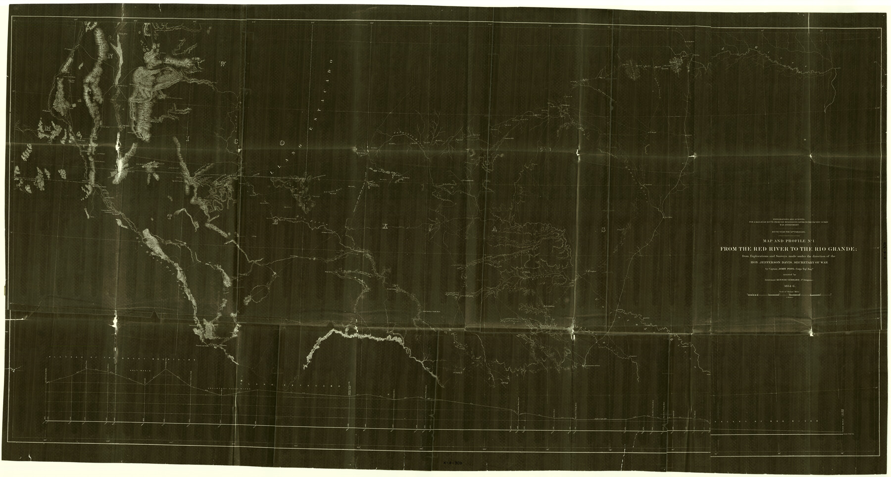
Map and Profile No. 1 from the Red River to the Rio Grande; from Explorations and surveys made under the direction of the Hon. Jeffeson Davis, Secretary of War
Explorations and Surveys for a Railroad Route from the Mississippi River to the Pacific Ocean.
K-4-30b
-
Map/Doc
4330
-
Collection
General Map Collection
-
Object Dates
1856 (Creation Date)
-
People and Organizations
War Department (Publisher)
Lieutenant Kenner Gerrard (Compiler)
Captain John Pope (Draftsman)
-
Subjects
Railroads
-
Height x Width
30.5 x 57.0 inches
77.5 x 144.8 cm
Part of: General Map Collection
Hudspeth County Rolled Sketch 36

Print $20.00
- Digital $50.00
Hudspeth County Rolled Sketch 36
1952
Size 30.8 x 19.9 inches
Map/Doc 6249
Flight Mission No. CLL-1N, Frame 160, Willacy County

Print $20.00
- Digital $50.00
Flight Mission No. CLL-1N, Frame 160, Willacy County
1954
Size 18.3 x 22.0 inches
Map/Doc 87051
Flight Mission No. BQR-5K, Frame 66, Brazoria County

Print $20.00
- Digital $50.00
Flight Mission No. BQR-5K, Frame 66, Brazoria County
1952
Size 18.8 x 22.5 inches
Map/Doc 84011
Brewster County Rolled Sketch 154

Print $20.00
- Digital $50.00
Brewster County Rolled Sketch 154
2001
Size 36.3 x 28.0 inches
Map/Doc 5325
San Patricio County Aerial Photograph Index Sheet 4

Print $20.00
- Digital $50.00
San Patricio County Aerial Photograph Index Sheet 4
1957
Size 23.3 x 19.3 inches
Map/Doc 83746
Northern Part of Laguna Madre

Print $20.00
- Digital $50.00
Northern Part of Laguna Madre
1992
Size 45.4 x 35.3 inches
Map/Doc 73532
Map of Hill County

Print $20.00
- Digital $50.00
Map of Hill County
1857
Size 21.5 x 25.6 inches
Map/Doc 3672
Denison Dam Quadrangle

Print $20.00
- Digital $50.00
Denison Dam Quadrangle
1999
Size 35.4 x 23.4 inches
Map/Doc 97366
El Paso County Sketch File 22a

Print $52.00
- Digital $50.00
El Paso County Sketch File 22a
1888
Size 14.2 x 8.7 inches
Map/Doc 22042
Hudspeth County Rolled Sketch 43

Print $40.00
- Digital $50.00
Hudspeth County Rolled Sketch 43
1932
Size 155.2 x 14.6 inches
Map/Doc 9216
Terrell County Sketch File 38

Print $6.00
- Digital $50.00
Terrell County Sketch File 38
1987
Size 11.3 x 8.8 inches
Map/Doc 38001

You may also like
General Highway Map, Ellis County, Texas

Print $20.00
General Highway Map, Ellis County, Texas
1961
Size 18.2 x 24.6 inches
Map/Doc 79453
Culberson County Sketch File 33

Print $10.00
- Digital $50.00
Culberson County Sketch File 33
Size 11.2 x 8.8 inches
Map/Doc 20286
Map of Texas from the most recent authorities

Map of Texas from the most recent authorities
1845
Size 11.2 x 17.2 inches
Map/Doc 4333
Tarrant County Working Sketch 11

Print $20.00
- Digital $50.00
Tarrant County Working Sketch 11
1986
Size 42.5 x 32.6 inches
Map/Doc 62428
Winkler County Sketch File 15

Print $10.00
- Digital $50.00
Winkler County Sketch File 15
1944
Size 14.3 x 8.6 inches
Map/Doc 40488
Bird's Eye View of the City of Dallas, Texas

Print $20.00
Bird's Eye View of the City of Dallas, Texas
1872
Size 18.6 x 25.6 inches
Map/Doc 89080
Roberts County Boundary File 2c

Print $28.00
- Digital $50.00
Roberts County Boundary File 2c
Size 9.5 x 28.3 inches
Map/Doc 58363
Graham's Addition Being a Subdivision of a Portion of Lot No. 1 of Spear League

Print $20.00
- Digital $50.00
Graham's Addition Being a Subdivision of a Portion of Lot No. 1 of Spear League
1914
Size 33.2 x 13.6 inches
Map/Doc 83426
Shackelford County Working Sketch 15

Print $20.00
- Digital $50.00
Shackelford County Working Sketch 15
2012
Size 28.4 x 20.7 inches
Map/Doc 93321
Knox County Sketch File 9

Print $4.00
- Digital $50.00
Knox County Sketch File 9
1889
Size 11.1 x 8.8 inches
Map/Doc 29221
Live Oak County Sketch File 8

Print $4.00
- Digital $50.00
Live Oak County Sketch File 8
1875
Size 7.6 x 7.9 inches
Map/Doc 30261
The Mexican Municipality of Brazoria. March 6, 1834

Print $20.00
The Mexican Municipality of Brazoria. March 6, 1834
2020
Size 16.0 x 21.7 inches
Map/Doc 96016