Presidio County Rolled Sketch D
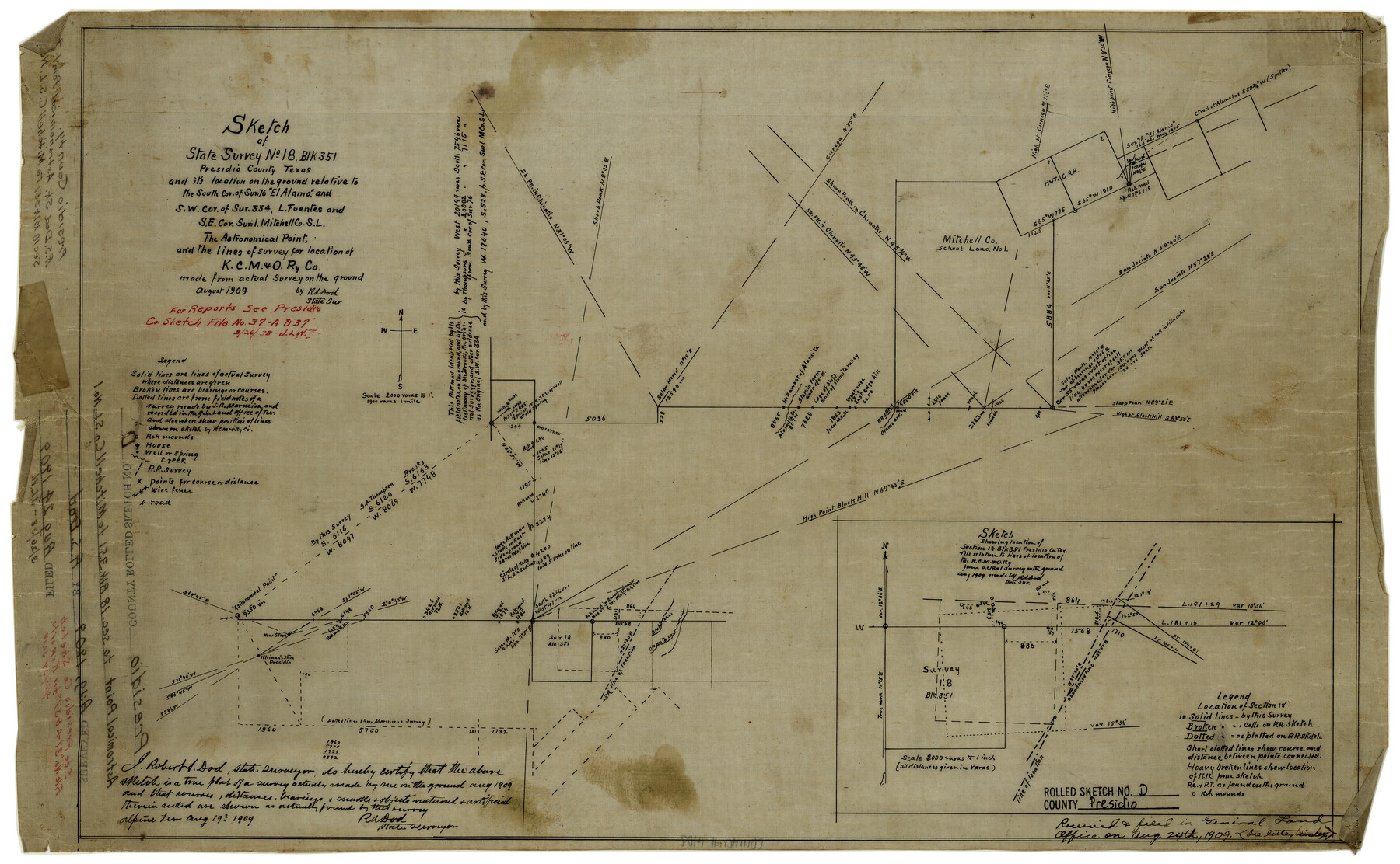
Sketch of State survey no. 18, Blk. 351, Presidio County, Texas and its location on the ground relative to the south cor. of sur. 76 "El Alamo" and SW cor. of sur. 334, L. Fuentes and SE cor. sur. 1, Mitchell Co. S.L.
-
Map/Doc
7408
-
Collection
General Map Collection
-
Object Dates
8/1909 (Survey Date)
8/24/1909 (File Date)
-
People and Organizations
R.S. Dod (Surveyor/Engineer)
-
Counties
Presidio
-
Subjects
Surveying Rolled Sketch
-
Height x Width
13.7 x 22.4 inches
34.8 x 56.9 cm
-
Medium
linen, manuscript
-
Scale
1" = 2000 varas
-
Comments
See Presidio County Sketch File 37 (34491) and Presidio County Sketch File 37A (34499) for reports and correspondence.
Related maps
Presidio County Sketch File 37

Print $16.00
- Digital $50.00
Presidio County Sketch File 37
Size 14.3 x 8.7 inches
Map/Doc 34491
Presidio County Sketch File 37A

Print $18.00
- Digital $50.00
Presidio County Sketch File 37A
Size 11.4 x 8.8 inches
Map/Doc 34499
Part of: General Map Collection
Zavala County Sketch File 22

Print $4.00
- Digital $50.00
Zavala County Sketch File 22
1885
Size 11.0 x 8.4 inches
Map/Doc 41378
Waller County Sketch File 2

Print $52.00
- Digital $50.00
Waller County Sketch File 2
Size 13.3 x 9.0 inches
Map/Doc 39570
Pecos County Rolled Sketch 107

Print $20.00
- Digital $50.00
Pecos County Rolled Sketch 107
1940
Size 21.9 x 45.4 inches
Map/Doc 7253
Harris County Working Sketch 114

Print $20.00
- Digital $50.00
Harris County Working Sketch 114
1983
Size 37.6 x 29.0 inches
Map/Doc 66006
Webb County Rolled Sketch 56

Print $20.00
- Digital $50.00
Webb County Rolled Sketch 56
1945
Size 22.2 x 23.7 inches
Map/Doc 8208
Mills County Working Sketch 6

Print $3.00
- Digital $50.00
Mills County Working Sketch 6
Size 12.1 x 10.9 inches
Map/Doc 71036
Williamson County Sketch File 6

Print $4.00
- Digital $50.00
Williamson County Sketch File 6
1848
Size 12.8 x 8.1 inches
Map/Doc 40314
Harris County Working Sketch 94

Print $20.00
- Digital $50.00
Harris County Working Sketch 94
1978
Size 20.9 x 40.2 inches
Map/Doc 65986
Lipscomb County Boundary File 11

Print $8.00
- Digital $50.00
Lipscomb County Boundary File 11
Size 11.1 x 8.7 inches
Map/Doc 56347
Cass County Working Sketch 24

Print $20.00
- Digital $50.00
Cass County Working Sketch 24
1973
Size 35.6 x 27.7 inches
Map/Doc 67927
Gillespie County

Print $20.00
- Digital $50.00
Gillespie County
1877
Size 20.1 x 24.5 inches
Map/Doc 3583
Lavaca County Sketch File 4

Print $6.00
- Digital $50.00
Lavaca County Sketch File 4
Size 8.2 x 15.3 inches
Map/Doc 29636
You may also like
Rio Grande Rectification Project, El Paso and Juarez Valley

Print $20.00
- Digital $50.00
Rio Grande Rectification Project, El Paso and Juarez Valley
1935
Size 10.8 x 29.6 inches
Map/Doc 60872
[Washington County RR. Co. Block 1 and Cherokee Iron Furnace Co. Block 1]
![92065, [Washington County RR. Co. Block 1 and Cherokee Iron Furnace Co. Block 1], Twichell Survey Records](https://historictexasmaps.com/wmedia_w700/maps/92065-1.tif.jpg)
Print $20.00
- Digital $50.00
[Washington County RR. Co. Block 1 and Cherokee Iron Furnace Co. Block 1]
1911
Size 22.4 x 25.4 inches
Map/Doc 92065
R. S. Coon's Blue Creek Ranch, Moore County, Texas

Print $20.00
- Digital $50.00
R. S. Coon's Blue Creek Ranch, Moore County, Texas
Size 15.8 x 15.7 inches
Map/Doc 91487
Map of Texas with population and location of principal towns and cities according to latest reliable statistics

Print $20.00
- Digital $50.00
Map of Texas with population and location of principal towns and cities according to latest reliable statistics
1911
Size 19.4 x 21.5 inches
Map/Doc 95875
Kendall County Sketch File 29

Print $14.00
- Digital $50.00
Kendall County Sketch File 29
1990
Size 14.0 x 8.5 inches
Map/Doc 95291
United States - Gulf Coast Texas - Southern part of Laguna Madre

Print $20.00
- Digital $50.00
United States - Gulf Coast Texas - Southern part of Laguna Madre
1933
Size 26.9 x 18.3 inches
Map/Doc 72952
[J. Blackwell survey 150, E. Parker, Asa Dorsett survey 827 and surrounding surveys]
![90422, [J. Blackwell survey 150, E. Parker, Asa Dorsett survey 827 and surrounding surveys], Twichell Survey Records](https://historictexasmaps.com/wmedia_w700/maps/90422-1.tif.jpg)
Print $20.00
- Digital $50.00
[J. Blackwell survey 150, E. Parker, Asa Dorsett survey 827 and surrounding surveys]
Size 35.0 x 30.3 inches
Map/Doc 90422
Falls County Sketch File 13

Print $4.00
- Digital $50.00
Falls County Sketch File 13
1870
Size 10.3 x 8.7 inches
Map/Doc 22368
The Inca, Machu Picchu Salutes the Sun

The Inca, Machu Picchu Salutes the Sun
Size 20.4 x 31.3 inches
Map/Doc 95935
Colorado County Working Sketch 18

Print $20.00
- Digital $50.00
Colorado County Working Sketch 18
1957
Size 31.2 x 37.3 inches
Map/Doc 68118
Sutton County Sketch File H

Print $22.00
- Digital $50.00
Sutton County Sketch File H
Size 14.3 x 8.7 inches
Map/Doc 37400
Bexar County Rolled Sketch 6

Print $40.00
- Digital $50.00
Bexar County Rolled Sketch 6
Size 36.6 x 54.9 inches
Map/Doc 81902