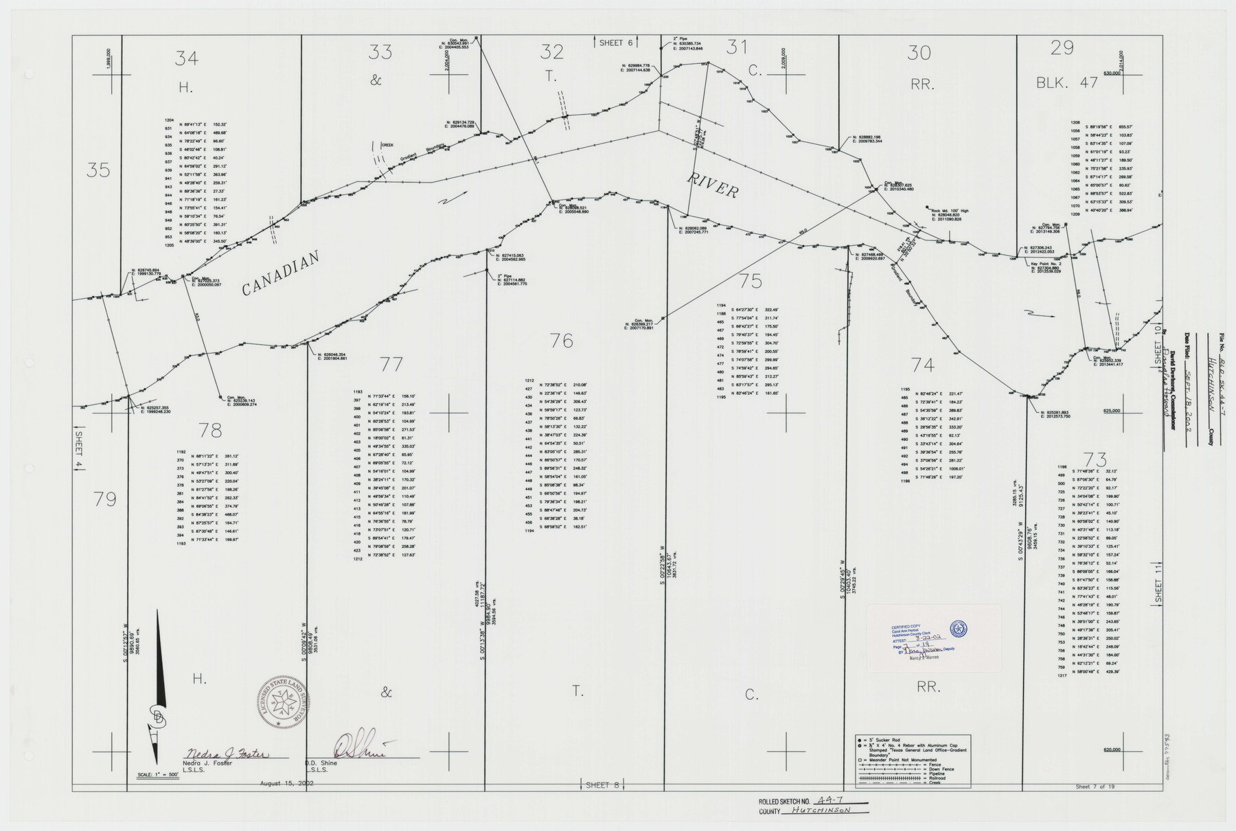
Hutchinson County Rolled Sketch 44-7
Canadian River Survey, Hutchinson County, Texas [Sheet 7 of 19]
-
Map/Doc
77543
-
Collection
General Map Collection
-
Object Dates
2002/8/15 (Creation Date)
2002/9/18 (File Date)
-
People and Organizations
Nedra J. Foster (Surveyor/Engineer)
D.D. Shine (Surveyor/Engineer)
-
Counties
Hutchinson
-
Subjects
Surveying Rolled Sketch
-
Height x Width
24.0 x 36.0 inches
61.0 x 91.4 cm
-
Medium
mylar, print
-
Scale
1" = 500 feet
Part of: General Map Collection
Medina County Working Sketch 19

Print $20.00
- Digital $50.00
Medina County Working Sketch 19
1980
Size 19.4 x 29.1 inches
Map/Doc 70934
Burnet County Sketch File 5

Print $4.00
- Digital $50.00
Burnet County Sketch File 5
Size 6.9 x 8.0 inches
Map/Doc 16680
Portion of States Submerged Area in Matagorda Bay

Print $20.00
- Digital $50.00
Portion of States Submerged Area in Matagorda Bay
1921
Size 15.7 x 15.1 inches
Map/Doc 2950
Flight Mission No. BRA-9M, Frame 77, Jefferson County

Print $20.00
- Digital $50.00
Flight Mission No. BRA-9M, Frame 77, Jefferson County
1953
Size 18.5 x 22.4 inches
Map/Doc 85660
Dickens County Working Sketch 14

Print $20.00
- Digital $50.00
Dickens County Working Sketch 14
1986
Size 25.5 x 30.7 inches
Map/Doc 62180
Boundary Between U.S. - Mexico, 1853

Print $20.00
- Digital $50.00
Boundary Between U.S. - Mexico, 1853
1954
Size 24.3 x 18.4 inches
Map/Doc 65416
Map of Survey of that portion of Fort Crockett, County of Galveston, Texas, lying east of 53rd Street & West of 39th Street, City of Galveston

Print $40.00
- Digital $50.00
Map of Survey of that portion of Fort Crockett, County of Galveston, Texas, lying east of 53rd Street & West of 39th Street, City of Galveston
1957
Size 23.0 x 59.8 inches
Map/Doc 73618
United States - Gulf Coast - Galveston to Rio Grande

Print $20.00
- Digital $50.00
United States - Gulf Coast - Galveston to Rio Grande
1940
Size 27.0 x 18.2 inches
Map/Doc 72755
Presidio County Rolled Sketch 57

Print $20.00
- Digital $50.00
Presidio County Rolled Sketch 57
1915
Size 22.8 x 17.3 inches
Map/Doc 7350
Map of the State of Texas [West Part]
![81921, Map of the State of Texas [West Part], General Map Collection](https://historictexasmaps.com/wmedia_w700/maps/81921.tif.jpg)
Print $40.00
- Digital $50.00
Map of the State of Texas [West Part]
1938
Size 68.7 x 38.2 inches
Map/Doc 81921
Hidalgo County Sketch File 7a

Print $4.00
- Digital $50.00
Hidalgo County Sketch File 7a
1886
Size 12.8 x 8.2 inches
Map/Doc 26405
Angelina County Sketch File 5a

Print $4.00
- Digital $50.00
Angelina County Sketch File 5a
1857
Size 8.6 x 7.7 inches
Map/Doc 12931
You may also like
Colorado River, East Bernard Sheet

Print $4.00
- Digital $50.00
Colorado River, East Bernard Sheet
1939
Size 24.3 x 29.9 inches
Map/Doc 65308
Galveston County NRC Article 33.136 Sketch 34

Print $20.00
- Digital $50.00
Galveston County NRC Article 33.136 Sketch 34
2005
Size 24.5 x 18.5 inches
Map/Doc 83405
Crosby County Sketch File 15

Print $20.00
- Digital $50.00
Crosby County Sketch File 15
1903
Size 28.7 x 20.4 inches
Map/Doc 11250
[Blocks K11, K6, K5, M19, H1, and Leagues North of Block S]
![91409, [Blocks K11, K6, K5, M19, H1, and Leagues North of Block S], Twichell Survey Records](https://historictexasmaps.com/wmedia_w700/maps/91409-1.tif.jpg)
Print $20.00
- Digital $50.00
[Blocks K11, K6, K5, M19, H1, and Leagues North of Block S]
1902
Size 33.3 x 25.3 inches
Map/Doc 91409

Val Verde County Working Sketch 5

Print $20.00
- Digital $50.00
Val Verde County Working Sketch 5
1909
Size 13.0 x 29.8 inches
Map/Doc 72140
Briscoe County Rolled Sketch 14

Print $40.00
- Digital $50.00
Briscoe County Rolled Sketch 14
1913
Size 36.0 x 48.9 inches
Map/Doc 8529
Eastland County Working Sketch 66

Print $20.00
- Digital $50.00
Eastland County Working Sketch 66
2014
Size 27.2 x 20.1 inches
Map/Doc 93708
Zavala County Sketch File 20

Print $4.00
- Digital $50.00
Zavala County Sketch File 20
1911
Size 9.1 x 8.2 inches
Map/Doc 41374
McCulloch County Working Sketch 5

Print $20.00
- Digital $50.00
McCulloch County Working Sketch 5
1961
Size 21.3 x 19.2 inches
Map/Doc 70680
Zavala County Rolled Sketch 28

Print $20.00
- Digital $50.00
Zavala County Rolled Sketch 28
1956
Size 29.6 x 41.2 inches
Map/Doc 8330
General Highway Map, Crockett County, Texas

Print $20.00
General Highway Map, Crockett County, Texas
1961
Size 18.1 x 24.6 inches
Map/Doc 79425