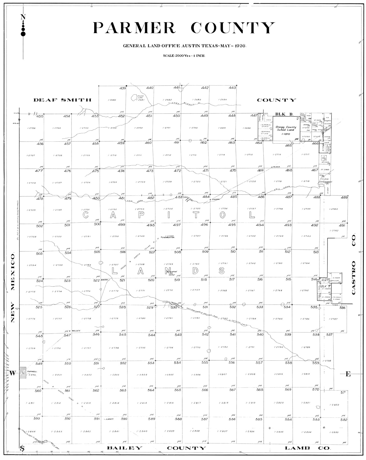
Parmer County
-
Map/Doc
77392
-
Collection
General Map Collection
-
Object Dates
1926 (Creation Date)
-
Counties
Parmer
-
Subjects
County
-
Height x Width
39.8 x 31.6 inches
101.1 x 80.3 cm
Part of: General Map Collection
Eastland County

Print $20.00
- Digital $50.00
Eastland County
1879
Size 21.3 x 21.3 inches
Map/Doc 3499
Marion County Working Sketch 10

Print $20.00
- Digital $50.00
Marion County Working Sketch 10
1949
Size 30.9 x 30.2 inches
Map/Doc 70785
Wharton County Sketch File 25

Print $4.00
- Digital $50.00
Wharton County Sketch File 25
1978
Size 11.1 x 8.7 inches
Map/Doc 39988
Flight Mission No. DIX-10P, Frame 166, Aransas County

Print $20.00
- Digital $50.00
Flight Mission No. DIX-10P, Frame 166, Aransas County
1956
Size 18.5 x 22.2 inches
Map/Doc 83956
Flight Mission No. CLL-1N, Frame 32, Willacy County

Print $20.00
- Digital $50.00
Flight Mission No. CLL-1N, Frame 32, Willacy County
1954
Size 17.5 x 19.4 inches
Map/Doc 87013

Travis County Rolled Sketch 27

Print $20.00
- Digital $50.00
Travis County Rolled Sketch 27
1945
Size 23.5 x 17.8 inches
Map/Doc 8029
Sutton County Rolled Sketch 63

Print $40.00
- Digital $50.00
Sutton County Rolled Sketch 63
Size 77.0 x 45.2 inches
Map/Doc 9979
Montgomery County Sketch File 3

Print $12.00
- Digital $50.00
Montgomery County Sketch File 3
1846
Size 4.5 x 8.3 inches
Map/Doc 31770
Water-Shed of the Pease River Drainage Area

Print $6.00
- Digital $50.00
Water-Shed of the Pease River Drainage Area
Size 14.9 x 31.0 inches
Map/Doc 65102
Runnels County

Print $20.00
- Digital $50.00
Runnels County
1898
Size 43.3 x 36.9 inches
Map/Doc 63009
Flight Mission No. BQR-16K, Frame 35, Brazoria County

Print $20.00
- Digital $50.00
Flight Mission No. BQR-16K, Frame 35, Brazoria County
1952
Size 18.5 x 22.2 inches
Map/Doc 84102
You may also like
Callahan County Sketch File 12

Print $40.00
- Digital $50.00
Callahan County Sketch File 12
1872
Size 17.8 x 26.2 inches
Map/Doc 11041
Red River County Working Sketch 48

Print $20.00
- Digital $50.00
Red River County Working Sketch 48
1970
Size 28.6 x 30.2 inches
Map/Doc 72031
Map of Extension Line from the Brazos River to the Waters of the Colorado River of the Memphis, El Paso & Pacific R.R. Company Land Reserve

Print $40.00
- Digital $50.00
Map of Extension Line from the Brazos River to the Waters of the Colorado River of the Memphis, El Paso & Pacific R.R. Company Land Reserve
1858
Size 16.8 x 82.9 inches
Map/Doc 64093
Flight Mission No. BRA-16M, Frame 123, Jefferson County

Print $20.00
- Digital $50.00
Flight Mission No. BRA-16M, Frame 123, Jefferson County
1953
Size 18.6 x 22.5 inches
Map/Doc 85733
La Salle County Working Sketch Graphic Index

Print $40.00
- Digital $50.00
La Salle County Working Sketch Graphic Index
1923
Size 48.2 x 42.0 inches
Map/Doc 76615
[Surveys in the Bexar District along the Nueces and Leona Rivers]
![116, [Surveys in the Bexar District along the Nueces and Leona Rivers], General Map Collection](https://historictexasmaps.com/wmedia_w700/maps/116.tif.jpg)
Print $3.00
- Digital $50.00
[Surveys in the Bexar District along the Nueces and Leona Rivers]
1845
Size 10.9 x 14.3 inches
Map/Doc 116

Map of Webb County

Print $20.00
- Digital $50.00
Map of Webb County
1878
Size 37.0 x 26.0 inches
Map/Doc 4130
Wilbarger County Sketch File 29

Print $18.00
- Digital $50.00
Wilbarger County Sketch File 29
2016
Size 11.0 x 8.5 inches
Map/Doc 95325
Hardin County Sketch File 16a

Print $3.00
- Digital $50.00
Hardin County Sketch File 16a
1837
Size 10.4 x 16.0 inches
Map/Doc 25129
Jeff Davis County Working Sketch 15

Print $20.00
- Digital $50.00
Jeff Davis County Working Sketch 15
1950
Size 34.6 x 29.0 inches
Map/Doc 66510
Map of Nacogdoches County

Print $20.00
- Digital $50.00
Map of Nacogdoches County
1881
Size 24.5 x 21.5 inches
Map/Doc 4600