Hardin County Sketch File 16a
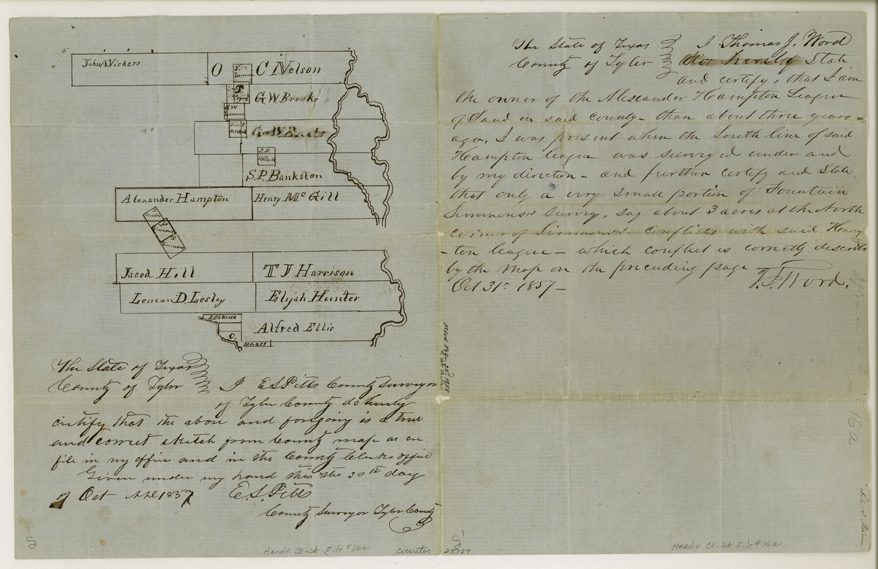
[Sketch showing the Alexander Hampton survey]
-
Map/Doc
25129
-
Collection
General Map Collection
-
Object Dates
1837/10/30 (Creation Date)
1837 (Survey Date)
-
People and Organizations
E.S. Pitts (Surveyor/Engineer)
-
Counties
Hardin
-
Subjects
Surveying Sketch File
-
Height x Width
10.4 x 16.0 inches
26.4 x 40.6 cm
-
Medium
paper, manuscript
Part of: General Map Collection
Pecos County Rolled Sketch 164

Print $20.00
- Digital $50.00
Pecos County Rolled Sketch 164
1965
Size 30.2 x 20.1 inches
Map/Doc 7287
Dimmit County Sketch File 37

Print $6.00
- Digital $50.00
Dimmit County Sketch File 37
1894
Size 10.4 x 12.7 inches
Map/Doc 21161
Comal County Working Sketch 2

Print $20.00
- Digital $50.00
Comal County Working Sketch 2
1940
Size 19.8 x 20.9 inches
Map/Doc 68168
Hardin County Working Sketch 34

Print $20.00
- Digital $50.00
Hardin County Working Sketch 34
1980
Size 15.7 x 12.1 inches
Map/Doc 63432
Gregg County Working Sketch 15

Print $20.00
- Digital $50.00
Gregg County Working Sketch 15
1941
Size 24.8 x 29.5 inches
Map/Doc 63282
Collin County Boundary File 18d

Print $20.00
- Digital $50.00
Collin County Boundary File 18d
Size 12.8 x 8.2 inches
Map/Doc 51739
Newton County Sketch File 43

Print $12.00
- Digital $50.00
Newton County Sketch File 43
1944
Size 11.2 x 8.6 inches
Map/Doc 32435
Presidio County Working Sketch 13

Print $20.00
- Digital $50.00
Presidio County Working Sketch 13
1941
Size 25.7 x 41.5 inches
Map/Doc 71689
Anderson County Rolled Sketch 14

Print $20.00
- Digital $50.00
Anderson County Rolled Sketch 14
1997
Size 30.1 x 36.5 inches
Map/Doc 77159
DeWitt County Working Sketch 10

Print $20.00
- Digital $50.00
DeWitt County Working Sketch 10
1980
Size 15.1 x 12.0 inches
Map/Doc 68600
Flight Mission No. BRA-9M, Frame 80, Jefferson County

Print $20.00
- Digital $50.00
Flight Mission No. BRA-9M, Frame 80, Jefferson County
1953
Size 18.6 x 22.5 inches
Map/Doc 85663
Pecos County Sketch File 53

Print $20.00
- Digital $50.00
Pecos County Sketch File 53
Size 18.0 x 38.9 inches
Map/Doc 10569
You may also like
PSL Field Notes for Block CS in Dallam County

PSL Field Notes for Block CS in Dallam County
Map/Doc 81649
Henderson County Rolled Sketch 11

Print $20.00
- Digital $50.00
Henderson County Rolled Sketch 11
1915
Size 29.4 x 42.5 inches
Map/Doc 75956
Hardeman County Boundary File 3b

Print $12.00
- Digital $50.00
Hardeman County Boundary File 3b
Size 14.1 x 8.7 inches
Map/Doc 54386
Angelina County Working Sketch 28

Print $20.00
- Digital $50.00
Angelina County Working Sketch 28
1954
Size 28.9 x 26.0 inches
Map/Doc 67110
Duval County Sketch File 86

Print $4.00
- Digital $50.00
Duval County Sketch File 86
1934
Size 11.4 x 8.8 inches
Map/Doc 21547
Tom Green County Working Sketch 12

Print $20.00
- Digital $50.00
Tom Green County Working Sketch 12
1975
Size 30.0 x 41.1 inches
Map/Doc 69381
Sabine River, West Extension Toll Bridge Sheet

Print $4.00
- Digital $50.00
Sabine River, West Extension Toll Bridge Sheet
1933
Size 15.2 x 19.3 inches
Map/Doc 65142
Callahan County Sketch File 12

Print $40.00
- Digital $50.00
Callahan County Sketch File 12
1872
Size 17.8 x 26.2 inches
Map/Doc 11041
Hardeman County Sketch File 7

Print $10.00
- Digital $50.00
Hardeman County Sketch File 7
Size 8.9 x 14.1 inches
Map/Doc 24997
General Highway Map. Detail of Cities and Towns in Cherokee County, Texas [Jacksonville, Rusk, Alto, Wells, and vicinities of these cities]
![79407, General Highway Map. Detail of Cities and Towns in Cherokee County, Texas [Jacksonville, Rusk, Alto, Wells, and vicinities of these cities], Texas State Library and Archives](https://historictexasmaps.com/wmedia_w700/maps/79407.tif.jpg)
Print $20.00
General Highway Map. Detail of Cities and Towns in Cherokee County, Texas [Jacksonville, Rusk, Alto, Wells, and vicinities of these cities]
1961
Size 18.2 x 24.9 inches
Map/Doc 79407
Tom Green County Working Sketch 15

Print $20.00
- Digital $50.00
Tom Green County Working Sketch 15
1988
Size 32.9 x 37.5 inches
Map/Doc 69384
Cottle County Sketch File 15

Print $4.00
- Digital $50.00
Cottle County Sketch File 15
1891
Size 11.2 x 9.0 inches
Map/Doc 19516