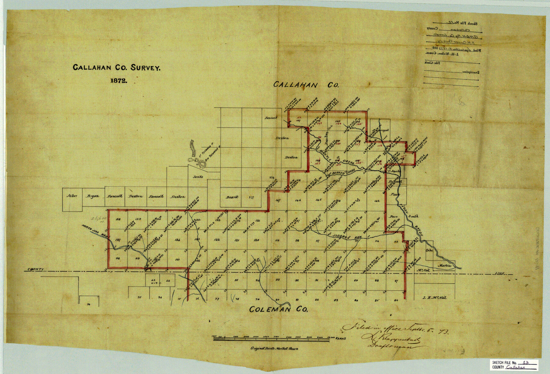
Callahan County Sketch File 12
[Sketch of G. H. & H. Ry. Co. lands in southwestern part of the county]
-
Map/Doc
11041
-
Collection
General Map Collection
-
Object Dates
1872 (Creation Date)
1873/9/5 (File Date)
-
Counties
Callahan Coleman
-
Subjects
Surveying Sketch File
-
Height x Width
17.8 x 26.2 inches
45.2 x 66.5 cm
-
Medium
paper, manuscript
-
Features
Mantle Creek
Barren Creek
Little Tecumseh P[eak]
Big Tecumseh P[eak]
North Jim Ned Creek
Jacobs Run
Pecan Bayou
Part of: General Map Collection

[Surveys in Austin's Colony along the Brazos and Bernard Rivers]
![43, [Surveys in Austin's Colony along the Brazos and Bernard Rivers], General Map Collection](https://historictexasmaps.com/wmedia_w700/maps/43.tif.jpg)
Print $20.00
- Digital $50.00
[Surveys in Austin's Colony along the Brazos and Bernard Rivers]
1835
Size 23.8 x 18.6 inches
Map/Doc 43
Parmer County

Print $20.00
- Digital $50.00
Parmer County
1926
Size 43.9 x 35.4 inches
Map/Doc 73259
[The S.K. Ry. of Texas, State Line to Pecos, Reeves Co., Texas]
![64159, [The S.K. Ry. of Texas, State Line to Pecos, Reeves Co., Texas], General Map Collection](https://historictexasmaps.com/wmedia_w700/maps/64159.tif.jpg)
Print $40.00
- Digital $50.00
[The S.K. Ry. of Texas, State Line to Pecos, Reeves Co., Texas]
1910
Size 19.4 x 130.6 inches
Map/Doc 64159
Galveston County NRC Article 33.136 Sketch 41

Print $28.00
- Digital $50.00
Galveston County NRC Article 33.136 Sketch 41
2006
Size 29.8 x 42.4 inches
Map/Doc 83074
Hudspeth County Working Sketch 65

Print $40.00
- Digital $50.00
Hudspeth County Working Sketch 65
2007
Size 32.9 x 61.6 inches
Map/Doc 88732
Pecos County Working Sketch 36

Print $20.00
- Digital $50.00
Pecos County Working Sketch 36
1939
Size 47.4 x 38.8 inches
Map/Doc 71508
Fort Bend County Sketch File 3a

Print $6.00
- Digital $50.00
Fort Bend County Sketch File 3a
1874
Size 8.3 x 8.0 inches
Map/Doc 22882
Flight Mission No. BRE-1P, Frame 113, Nueces County

Print $20.00
- Digital $50.00
Flight Mission No. BRE-1P, Frame 113, Nueces County
1956
Size 18.6 x 22.6 inches
Map/Doc 86679
Wheeler County Sketch File A

Print $20.00
- Digital $50.00
Wheeler County Sketch File A
1888
Size 15.5 x 31.8 inches
Map/Doc 12677
Flight Mission No. CGN-3P, Frame 142, San Patricio County

Print $20.00
- Digital $50.00
Flight Mission No. CGN-3P, Frame 142, San Patricio County
1956
Size 18.5 x 22.1 inches
Map/Doc 86986
Flight Mission No. DCL-5C, Frame 27, Kenedy County

Print $20.00
- Digital $50.00
Flight Mission No. DCL-5C, Frame 27, Kenedy County
1943
Size 18.5 x 22.4 inches
Map/Doc 85839
You may also like
Nueces County Rolled Sketch 100

Print $20.00
- Digital $50.00
Nueces County Rolled Sketch 100
Size 21.3 x 32.7 inches
Map/Doc 10697
McCulloch County

Print $20.00
- Digital $50.00
McCulloch County
1949
Size 47.0 x 35.8 inches
Map/Doc 73234
Map of Clemens State Farm, Brazoria County, Texas

Print $20.00
- Digital $50.00
Map of Clemens State Farm, Brazoria County, Texas
1934
Size 31.2 x 36.1 inches
Map/Doc 62984
Young County Working Sketch 14

Print $20.00
- Digital $50.00
Young County Working Sketch 14
1944
Size 15.3 x 16.0 inches
Map/Doc 62037
Kinney County Sketch File 37

Print $20.00
- Digital $50.00
Kinney County Sketch File 37
Size 19.0 x 23.4 inches
Map/Doc 11950
Montgomery County Sketch File 41

Print $8.00
- Digital $50.00
Montgomery County Sketch File 41
2004
Size 14.0 x 8.5 inches
Map/Doc 82447
Your Opportunity - the Magic Valley - Money Will Grow on Trees! Learn Where How and Why!

Your Opportunity - the Magic Valley - Money Will Grow on Trees! Learn Where How and Why!
1928
Map/Doc 96740
Maps of Gulf Intracoastal Waterway, Texas - Sabine River to the Rio Grande and connecting waterways including ship channels

Print $20.00
- Digital $50.00
Maps of Gulf Intracoastal Waterway, Texas - Sabine River to the Rio Grande and connecting waterways including ship channels
1966
Size 14.6 x 22.2 inches
Map/Doc 61967
Jim Hogg County Working Sketch 2

Print $20.00
- Digital $50.00
Jim Hogg County Working Sketch 2
1933
Size 41.2 x 29.3 inches
Map/Doc 66588
Milam County Sketch File 2

Print $4.00
- Digital $50.00
Milam County Sketch File 2
1849
Size 8.0 x 12.4 inches
Map/Doc 31627
Brazoria County Sketch File 30

Print $4.00
- Digital $50.00
Brazoria County Sketch File 30
1893
Size 11.1 x 8.7 inches
Map/Doc 15037
Coleman County Working Sketch Graphic Index

Print $40.00
- Digital $50.00
Coleman County Working Sketch Graphic Index
1945
Size 54.0 x 36.3 inches
Map/Doc 76497