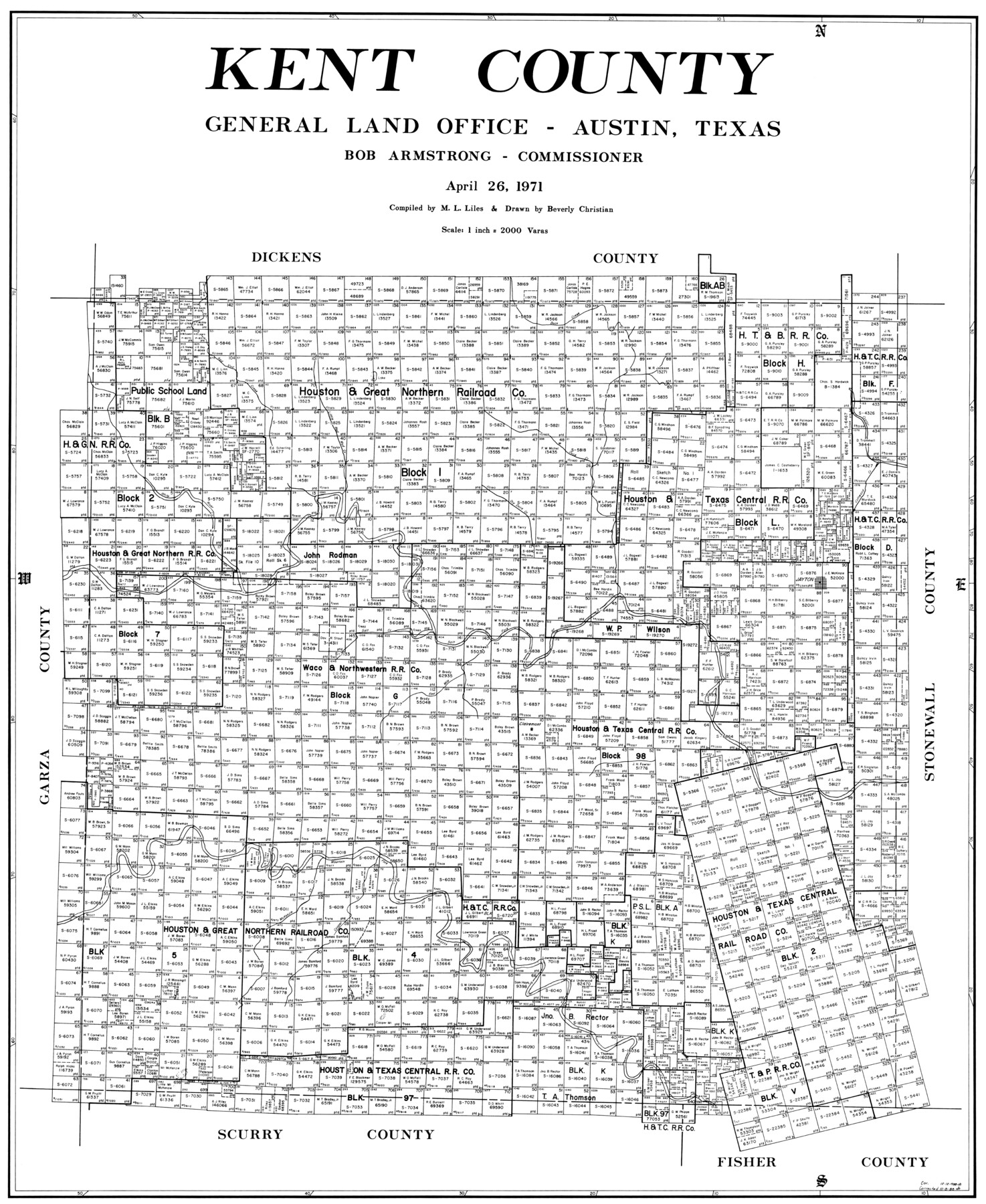
Kent County
-
Map/Doc
77338
-
Collection
General Map Collection
-
Object Dates
1971/4/26 (Creation Date)
-
People and Organizations
Beverly Christian (Draftsman)
M. L. Liles (Compiler)
-
Counties
Kent
-
Subjects
County
-
Height x Width
40.9 x 33.5 inches
103.9 x 85.1 cm
Part of: General Map Collection
Nueces County Sketch File 13a

Print $12.00
- Digital $50.00
Nueces County Sketch File 13a
1889
Size 13.8 x 9.0 inches
Map/Doc 32539
Maps of Gulf Intracoastal Waterway, Texas - Sabine River to the Rio Grande and connecting waterways including ship channels

Print $20.00
- Digital $50.00
Maps of Gulf Intracoastal Waterway, Texas - Sabine River to the Rio Grande and connecting waterways including ship channels
1966
Size 14.6 x 22.2 inches
Map/Doc 61952
Coryell County Sketch File 25

Print $4.00
- Digital $50.00
Coryell County Sketch File 25
1873
Size 12.8 x 8.3 inches
Map/Doc 19391

Lubbock County Sketch File 8

Print $8.00
- Digital $50.00
Lubbock County Sketch File 8
1907
Size 11.1 x 8.5 inches
Map/Doc 30426
Northeast Part of Webb County

Print $20.00
- Digital $50.00
Northeast Part of Webb County
1986
Size 34.6 x 45.7 inches
Map/Doc 77452
Midland County Boundary File 2

Print $24.00
- Digital $50.00
Midland County Boundary File 2
Size 8.9 x 5.5 inches
Map/Doc 57162
Val Verde County Rolled Sketch 77

Print $20.00
- Digital $50.00
Val Verde County Rolled Sketch 77
1981
Size 36.2 x 37.4 inches
Map/Doc 10087
Rusk County Working Sketch 16

Print $20.00
- Digital $50.00
Rusk County Working Sketch 16
1956
Size 32.1 x 42.7 inches
Map/Doc 63651

Port of Corpus Christi Inner Harbor Industrial District, Nueces County Navigation District Number One

Print $40.00
- Digital $50.00
Port of Corpus Christi Inner Harbor Industrial District, Nueces County Navigation District Number One
1972
Size 43.6 x 101.3 inches
Map/Doc 78635
Lipscomb County Sketch File 2

Print $20.00
- Digital $50.00
Lipscomb County Sketch File 2
1902
Size 10.7 x 8.2 inches
Map/Doc 30223
You may also like
Crane County Rolled Sketch 23

Print $20.00
- Digital $50.00
Crane County Rolled Sketch 23
2002
Size 23.9 x 34.3 inches
Map/Doc 76426
Starr County Boundary File 99

Print $56.00
- Digital $50.00
Starr County Boundary File 99
Size 9.2 x 6.2 inches
Map/Doc 58846
Map of Bell County

Print $40.00
- Digital $50.00
Map of Bell County
1896
Size 49.0 x 53.5 inches
Map/Doc 4768
Smith County Rolled Sketch 6A2

Print $40.00
- Digital $50.00
Smith County Rolled Sketch 6A2
1934
Size 48.7 x 36.7 inches
Map/Doc 10702
Flight Mission No. DQN-4K, Frame 3, Calhoun County

Print $20.00
- Digital $50.00
Flight Mission No. DQN-4K, Frame 3, Calhoun County
1953
Size 18.9 x 22.4 inches
Map/Doc 84368
Map of the River Sabine shewing that portion of the Boundary between the Republic of Texas and the United States included between Logan's Ferry and the Intersection of the 32nd degree of N. Latitude with the Western bank of Sabine River

Print $20.00
- Digital $50.00
Map of the River Sabine shewing that portion of the Boundary between the Republic of Texas and the United States included between Logan's Ferry and the Intersection of the 32nd degree of N. Latitude with the Western bank of Sabine River
1842
Size 19.2 x 27.3 inches
Map/Doc 65410
Gaines County Rolled Sketch 25

Print $20.00
- Digital $50.00
Gaines County Rolled Sketch 25
1977
Size 23.6 x 19.4 inches
Map/Doc 5939
Angelina County Working Sketch 23

Print $20.00
- Digital $50.00
Angelina County Working Sketch 23
1953
Size 19.8 x 32.6 inches
Map/Doc 67105
Medina County

Print $40.00
- Digital $50.00
Medina County
1976
Size 52.5 x 43.2 inches
Map/Doc 73237
[Sketch for Mineral Application 16700 - Pecos River Bed]
![2808, [Sketch for Mineral Application 16700 - Pecos River Bed], General Map Collection](https://historictexasmaps.com/wmedia_w700/maps/2808.tif.jpg)
Print $20.00
- Digital $50.00
[Sketch for Mineral Application 16700 - Pecos River Bed]
1927
Size 19.9 x 30.9 inches
Map/Doc 2808
Brazos Santiago, Texas

Print $20.00
- Digital $50.00
Brazos Santiago, Texas
1882
Size 9.0 x 16.9 inches
Map/Doc 97186
La Salle County Sketch File 28a

Print $6.00
- Digital $50.00
La Salle County Sketch File 28a
1898
Size 4.5 x 5.2 inches
Map/Doc 29558