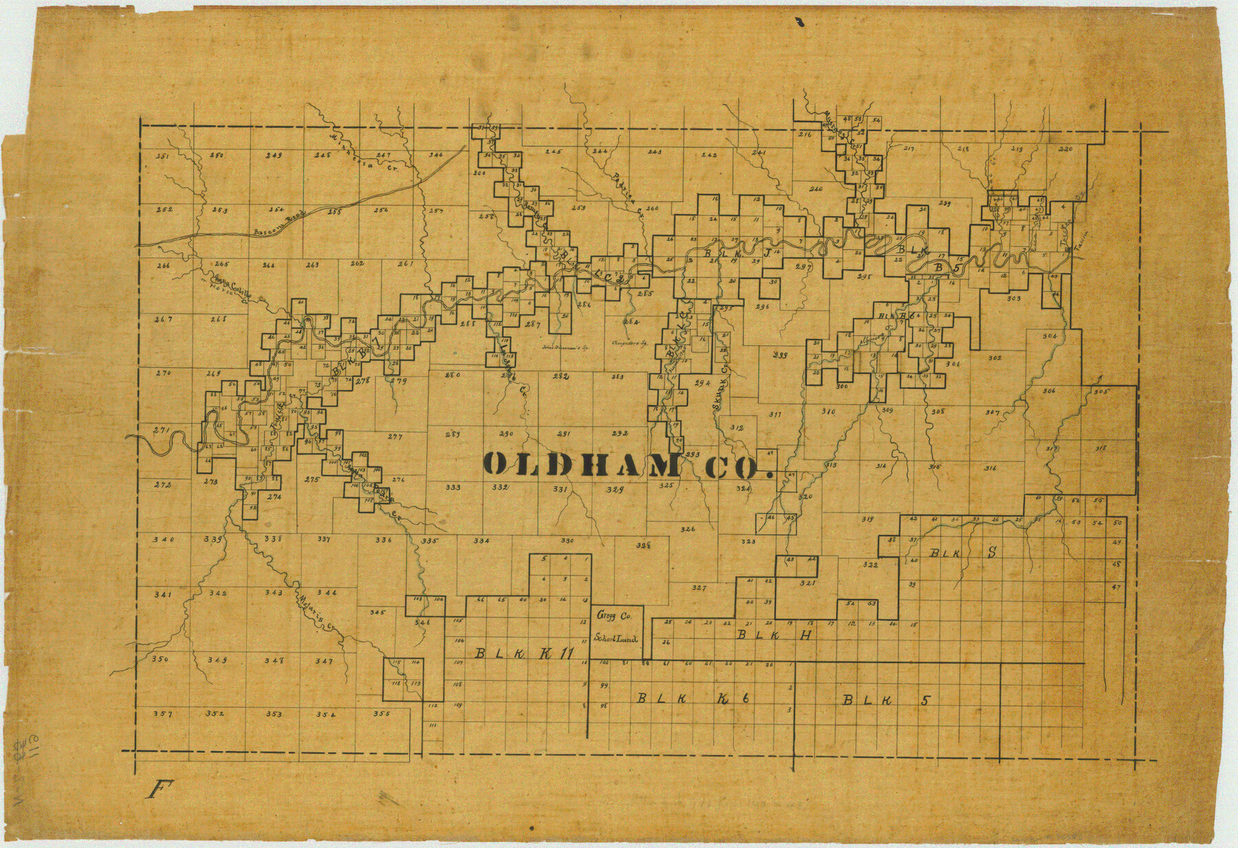
Oldham Co.
N-2-119
-
Map/Doc
75985
-
Collection
General Map Collection
-
Counties
Oldham
-
Subjects
County
-
Height x Width
19.4 x 28.3 inches
49.3 x 71.9 cm
-
Comments
Capitol land map.
Part of: General Map Collection
Galveston County Boundary File 32a

Print $10.00
- Digital $50.00
Galveston County Boundary File 32a
Size 11.4 x 8.9 inches
Map/Doc 53666
Delta County Sketch File 2

Print $4.00
- Digital $50.00
Delta County Sketch File 2
1871
Size 8.4 x 13.2 inches
Map/Doc 20670
Map representing the surveys made in Bexar County

Print $40.00
- Digital $50.00
Map representing the surveys made in Bexar County
1839
Size 75.7 x 35.1 inches
Map/Doc 93365
North Part Brewster Co.

Print $20.00
- Digital $50.00
North Part Brewster Co.
1914
Size 38.7 x 47.8 inches
Map/Doc 16948
Nacogdoches County Working Sketch 9

Print $20.00
- Digital $50.00
Nacogdoches County Working Sketch 9
1967
Size 27.6 x 32.1 inches
Map/Doc 71225
Galveston County NRC Article 33.136 Sketch 50

Print $24.00
- Digital $50.00
Galveston County NRC Article 33.136 Sketch 50
2008
Size 24.0 x 36.3 inches
Map/Doc 88750
Stonewall County Rolled Sketch A and B

Print $20.00
- Digital $50.00
Stonewall County Rolled Sketch A and B
1886
Size 17.8 x 45.3 inches
Map/Doc 9957
Gregg County Rolled Sketch 20

Print $20.00
- Digital $50.00
Gregg County Rolled Sketch 20
1957
Size 34.6 x 44.7 inches
Map/Doc 6478
Webb County Rolled Sketch 3

Print $20.00
- Digital $50.00
Webb County Rolled Sketch 3
1884
Size 19.7 x 24.8 inches
Map/Doc 8170
Map of the Straits of Florida and Gulf of Mexico

Print $20.00
- Digital $50.00
Map of the Straits of Florida and Gulf of Mexico
1851
Size 18.3 x 27.4 inches
Map/Doc 72675
Webb County Rolled Sketch 21

Print $20.00
- Digital $50.00
Webb County Rolled Sketch 21
1930
Size 32.9 x 23.0 inches
Map/Doc 8183
Uvalde County Working Sketch 48

Print $20.00
- Digital $50.00
Uvalde County Working Sketch 48
1980
Size 15.6 x 17.9 inches
Map/Doc 72118
You may also like
Lynn County Rolled Sketch S

Print $20.00
- Digital $50.00
Lynn County Rolled Sketch S
Size 21.1 x 38.7 inches
Map/Doc 6654
Parker County Sketch File 37

Print $4.00
- Digital $50.00
Parker County Sketch File 37
Size 4.8 x 8.1 inches
Map/Doc 33581
San Augustine County Working Sketch 18

Print $20.00
- Digital $50.00
San Augustine County Working Sketch 18
1964
Size 22.7 x 23.1 inches
Map/Doc 63706
Montague County Working Sketch 1

Print $20.00
- Digital $50.00
Montague County Working Sketch 1
Size 18.7 x 32.5 inches
Map/Doc 71067
McCulloch County Rolled Sketch 5

Print $20.00
- Digital $50.00
McCulloch County Rolled Sketch 5
Size 25.7 x 20.9 inches
Map/Doc 6716
Pecos County Rolled Sketch 189

Print $20.00
- Digital $50.00
Pecos County Rolled Sketch 189
1998
Size 22.2 x 33.7 inches
Map/Doc 7307
Sabine Bank to East Bay including Heald Bank

Print $20.00
- Digital $50.00
Sabine Bank to East Bay including Heald Bank
1946
Size 44.8 x 33.9 inches
Map/Doc 69845
Kent County Boundary File 4

Print $20.00
- Digital $50.00
Kent County Boundary File 4
Size 8.8 x 4.6 inches
Map/Doc 55828
Cherokee County Working Sketch 17

Print $40.00
- Digital $50.00
Cherokee County Working Sketch 17
1958
Size 81.6 x 43.3 inches
Map/Doc 67972
Webb County Sketch File 54

Print $46.00
- Digital $50.00
Webb County Sketch File 54
1939
Size 11.3 x 8.8 inches
Map/Doc 39841
Burleson County Working Sketch 23

Print $20.00
- Digital $50.00
Burleson County Working Sketch 23
1980
Size 17.9 x 16.6 inches
Map/Doc 67742
