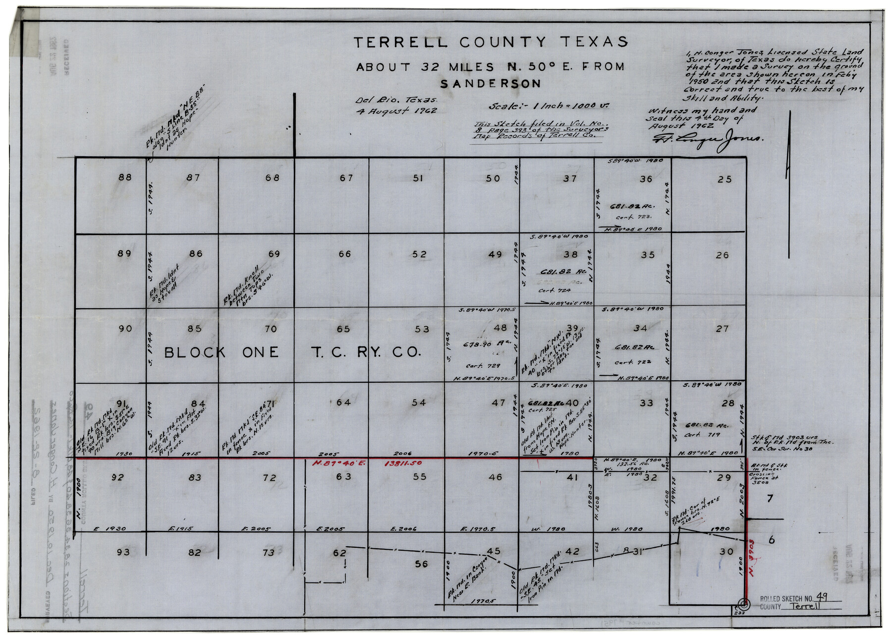
Terrell County Rolled Sketch 49
Terrell County [showing part of Block 1, T. C. Ry. Co.]
-
Map/Doc
7951
-
Collection
General Map Collection
-
Object Dates
8/4/1962 (Creation Date)
8/22/1962 (File Date)
-
People and Organizations
H. Conger Jones (Surveyor/Engineer)
-
Counties
Terrell
-
Subjects
Surveying Rolled Sketch
-
Height x Width
17.3 x 24.1 inches
43.9 x 61.2 cm
-
Medium
linen, manuscript
-
Scale
1" = 1000 varas
Part of: General Map Collection
Plat of South 1/2 of Colorado River Channel in McCulloch Co., Texas from Concho County line down river 34 mile 315 varas

Print $40.00
- Digital $50.00
Plat of South 1/2 of Colorado River Channel in McCulloch Co., Texas from Concho County line down river 34 mile 315 varas
1918
Size 41.5 x 104.6 inches
Map/Doc 2463
Wichita County Boundary File 2

Print $30.00
- Digital $50.00
Wichita County Boundary File 2
Size 9.1 x 4.7 inches
Map/Doc 59900

South Sulphur River, Harpers Crossing Sheet

Print $20.00
- Digital $50.00
South Sulphur River, Harpers Crossing Sheet
1925
Size 42.2 x 29.2 inches
Map/Doc 65169
Starr County Sketch File D

Print $8.00
- Digital $50.00
Starr County Sketch File D
1892
Size 14.2 x 8.7 inches
Map/Doc 36915
A Map of Part of Panola County [Judicial District]
![328, A Map of Part of Panola County [Judicial District], General Map Collection](https://historictexasmaps.com/wmedia_w700/maps/328.tif.jpg)
Print $20.00
- Digital $50.00
A Map of Part of Panola County [Judicial District]
1841
Size 18.3 x 15.4 inches
Map/Doc 328
Erath County Sketch File 32

Print $8.00
- Digital $50.00
Erath County Sketch File 32
1936
Size 11.5 x 8.8 inches
Map/Doc 22311
Parker County Rolled Sketch 4

Print $20.00
- Digital $50.00
Parker County Rolled Sketch 4
Size 28.0 x 34.1 inches
Map/Doc 7205
Jones County Sketch File 13

Print $20.00
- Digital $50.00
Jones County Sketch File 13
Size 43.5 x 35.7 inches
Map/Doc 10511
Galveston County NRC Article 33.136 Sketch 35

Print $42.00
- Digital $50.00
Galveston County NRC Article 33.136 Sketch 35
2005
Size 24.3 x 36.6 inches
Map/Doc 83406
Pecos County Working Sketch 111

Print $40.00
- Digital $50.00
Pecos County Working Sketch 111
1972
Size 32.9 x 69.6 inches
Map/Doc 71584
Map of Kendall County

Print $20.00
- Digital $50.00
Map of Kendall County
1862
Size 21.0 x 20.0 inches
Map/Doc 3754
You may also like
Texas-United States Boundary Line 2

Print $22.00
- Digital $50.00
Texas-United States Boundary Line 2
1882
Size 8.3 x 7.3 inches
Map/Doc 74976
Official Highway Map of Texas

Print $20.00
Official Highway Map of Texas
1928
Size 42.3 x 46.2 inches
Map/Doc 79746
Flight Mission No. DQN-1K, Frame 69, Calhoun County

Print $20.00
- Digital $50.00
Flight Mission No. DQN-1K, Frame 69, Calhoun County
1953
Size 18.5 x 22.2 inches
Map/Doc 84156
Williamson County Sketch File 1

Print $4.00
- Digital $50.00
Williamson County Sketch File 1
1847
Size 8.8 x 10.1 inches
Map/Doc 40299
Topographical Map of the Rio Grande, Sheet No. 8

Print $20.00
- Digital $50.00
Topographical Map of the Rio Grande, Sheet No. 8
1912
Map/Doc 89532
Kleberg County, Cayo del Grullo

Print $20.00
- Digital $50.00
Kleberg County, Cayo del Grullo
1952
Size 32.6 x 29.0 inches
Map/Doc 73506
Galveston County Sketch File 11a

Print $4.00
- Digital $50.00
Galveston County Sketch File 11a
1877
Size 7.8 x 8.4 inches
Map/Doc 23376
Sketch showing the Fred Turner surveys in Pecos County, Texas

Print $20.00
- Digital $50.00
Sketch showing the Fred Turner surveys in Pecos County, Texas
1928
Size 28.9 x 36.0 inches
Map/Doc 91590
Correspondence between the Political Chief of Nacogdoches and the Ayuntamiento (CPCNA)

Correspondence between the Political Chief of Nacogdoches and the Ayuntamiento (CPCNA)
Size 12.7 x 9.7 inches
Map/Doc 94263
Map showing lands surveyed by Sylvan Sanders in the Southwestern Part of Jack County, Texas for Buttram Petroleum Corporation

Print $20.00
- Digital $50.00
Map showing lands surveyed by Sylvan Sanders in the Southwestern Part of Jack County, Texas for Buttram Petroleum Corporation
1926
Size 29.3 x 25.6 inches
Map/Doc 92159
Concho County Working Sketch 20

Print $20.00
- Digital $50.00
Concho County Working Sketch 20
1957
Size 40.0 x 38.1 inches
Map/Doc 68202
Kimble County Sketch File 37

Print $4.00
- Digital $50.00
Kimble County Sketch File 37
1892
Size 11.2 x 8.9 inches
Map/Doc 28990