Dawson County Sketch File C
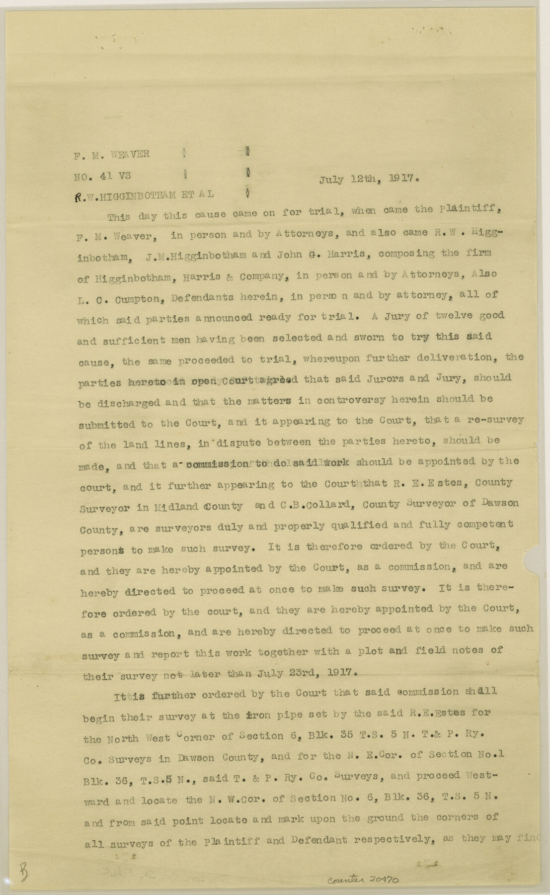
[Certified copy of Court Decree: F. M. Weaver vs. R. W. Higgenbotham et al]
-
Map/Doc
20470
-
Collection
General Map Collection
-
Object Dates
1917/7/12 (Creation Date)
1917/9/17 (File Date)
1917 (Survey Date)
-
People and Organizations
Robert E. Estes (Surveyor/Engineer)
C.B. Collard (Surveyor/Engineer)
R.S. Dod (Surveyor/Engineer)
J.R. Manry (Chainman)
Creek Rhea (Chainman)
-
Counties
Dawson Midland
-
Subjects
Surveying Sketch File
-
Height x Width
14.3 x 8.8 inches
36.3 x 22.4 cm
-
Medium
paper, print
-
Features
Weavers Ranch House
Sulphur Draw
Lamesa
Cupola School House
Sulphur Draw
Part of: General Map Collection
Kimble County Working Sketch 14

Print $20.00
- Digital $50.00
Kimble County Working Sketch 14
1923
Size 17.2 x 13.2 inches
Map/Doc 70082
Brewster County Rolled Sketch 24F

Print $20.00
- Digital $50.00
Brewster County Rolled Sketch 24F
1910
Size 14.5 x 17.7 inches
Map/Doc 5213
Lee County Sketch File 7

Print $36.00
- Digital $50.00
Lee County Sketch File 7
1838
Size 3.6 x 3.5 inches
Map/Doc 29688
Navigation Maps of Gulf Intracoastal Waterway, Port Arthur to Brownsville, Texas

Print $4.00
- Digital $50.00
Navigation Maps of Gulf Intracoastal Waterway, Port Arthur to Brownsville, Texas
1951
Size 16.8 x 21.6 inches
Map/Doc 65419
Kimble County Working Sketch 20

Print $20.00
- Digital $50.00
Kimble County Working Sketch 20
1929
Size 36.2 x 27.8 inches
Map/Doc 70088
Nueces County Rolled Sketch 98

Print $34.00
- Digital $50.00
Nueces County Rolled Sketch 98
1984
Size 24.5 x 36.4 inches
Map/Doc 7059
Hemphill County Sketch File 7

Print $20.00
- Digital $50.00
Hemphill County Sketch File 7
1924
Size 18.5 x 20.4 inches
Map/Doc 11753
Flight Mission No. CGI-3G, Frame 16, Cameron County

Print $20.00
- Digital $50.00
Flight Mission No. CGI-3G, Frame 16, Cameron County
1950
Size 18.5 x 18.3 inches
Map/Doc 84664
Asher & Adams' Geological Map - United States and Territories

Print $20.00
- Digital $50.00
Asher & Adams' Geological Map - United States and Territories
1874
Size 17.9 x 24.9 inches
Map/Doc 95175
Flight Mission No. DAG-23K, Frame 170, Matagorda County

Print $20.00
- Digital $50.00
Flight Mission No. DAG-23K, Frame 170, Matagorda County
1953
Size 18.6 x 22.4 inches
Map/Doc 86508
Hansford County Boundary File 3a

Print $80.00
- Digital $50.00
Hansford County Boundary File 3a
Size 15.3 x 64.7 inches
Map/Doc 54275
Cass County Working Sketch 45

Print $20.00
- Digital $50.00
Cass County Working Sketch 45
1989
Size 21.3 x 30.1 inches
Map/Doc 67948
You may also like
Briscoe County Sketch File G

Print $40.00
- Digital $50.00
Briscoe County Sketch File G
1918
Size 17.7 x 22.4 inches
Map/Doc 11004
Harris County Rolled Sketch 70

Print $20.00
- Digital $50.00
Harris County Rolled Sketch 70
1942
Size 29.6 x 36.2 inches
Map/Doc 6110
Dimmit County Sketch File 36

Print $6.00
- Digital $50.00
Dimmit County Sketch File 36
1894
Size 4.3 x 13.3 inches
Map/Doc 21158
Culberson County Rolled Sketch 35

Print $20.00
- Digital $50.00
Culberson County Rolled Sketch 35
1934
Size 19.1 x 10.9 inches
Map/Doc 5659
Map of Galveston Harbor and City

Print $40.00
- Digital $50.00
Map of Galveston Harbor and City
1850
Size 31.0 x 52.0 inches
Map/Doc 69856
Lynn County Rolled Sketch A

Print $20.00
- Digital $50.00
Lynn County Rolled Sketch A
1901
Size 33.5 x 34.2 inches
Map/Doc 9471
Morris County Rolled Sketch 2A

Print $20.00
- Digital $50.00
Morris County Rolled Sketch 2A
Size 24.2 x 19.0 inches
Map/Doc 10276

Rains County Boundary File 2

Print $4.00
- Digital $50.00
Rains County Boundary File 2
Size 8.2 x 5.8 inches
Map/Doc 58092
Menard County Working Sketch 14

Print $20.00
- Digital $50.00
Menard County Working Sketch 14
1939
Size 19.2 x 19.8 inches
Map/Doc 70961
Wilbarger County Sketch File 23

Print $4.00
- Digital $50.00
Wilbarger County Sketch File 23
1887
Size 14.2 x 8.8 inches
Map/Doc 40223
Burnet County Working Sketch 1

Print $20.00
- Digital $50.00
Burnet County Working Sketch 1
1916
Size 22.4 x 31.9 inches
Map/Doc 67844