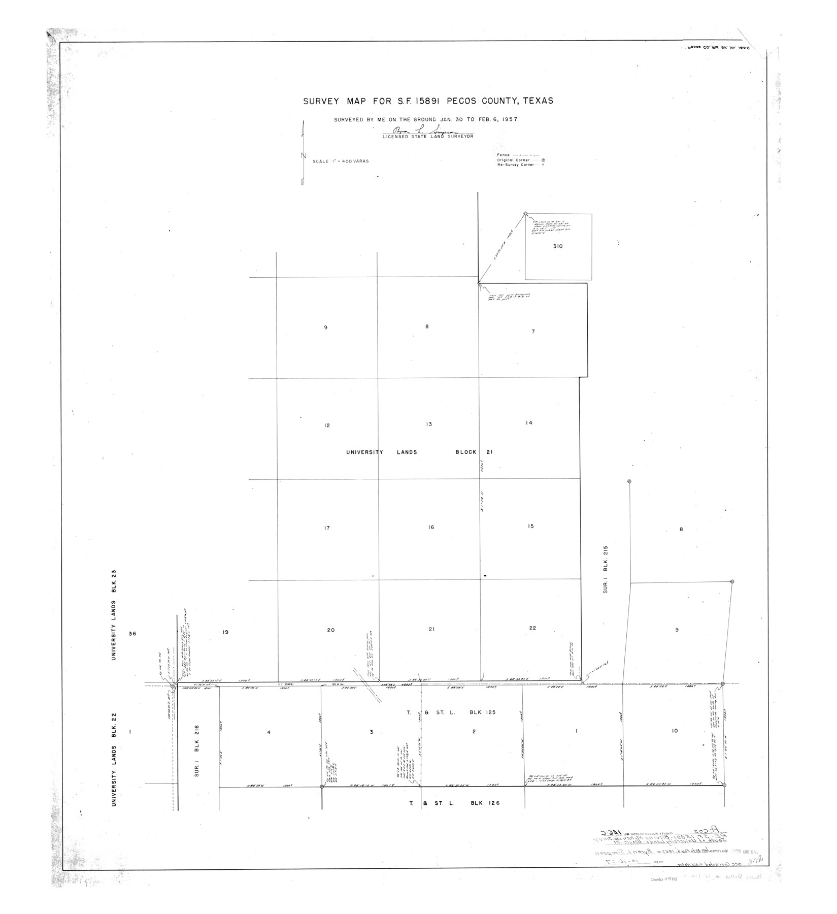
Pecos County Rolled Sketch 146C
Survey map for SF-15891, Pecos County, Texas
-
Map/Doc
9743
-
Collection
General Map Collection
-
Object Dates
1957/2/6 (Survey Date)
1957/10/30 (File Date)
-
People and Organizations
Byron L. Simpson (Surveyor/Engineer)
-
Counties
Pecos
-
Subjects
Surveying Rolled Sketch
-
Height x Width
43.1 x 39.5 inches
109.5 x 100.3 cm
-
Scale
1" = 400 varas
Part of: General Map Collection
Motley County Sketch File 36 (S)

Print $4.00
- Digital $50.00
Motley County Sketch File 36 (S)
1893
Size 11.0 x 8.8 inches
Map/Doc 32220
Atascosa County Working Sketch 7

Print $3.00
- Digital $50.00
Atascosa County Working Sketch 7
1913
Size 14.0 x 9.4 inches
Map/Doc 67203
Flight Mission No. BRA-7M, Frame 27, Jefferson County

Print $20.00
- Digital $50.00
Flight Mission No. BRA-7M, Frame 27, Jefferson County
1953
Size 18.5 x 22.3 inches
Map/Doc 85478
King County Boundary File 6

Print $16.00
- Digital $50.00
King County Boundary File 6
Size 9.2 x 6.6 inches
Map/Doc 64927
Flight Mission No. CUG-1P, Frame 108, Kleberg County

Print $20.00
- Digital $50.00
Flight Mission No. CUG-1P, Frame 108, Kleberg County
1956
Size 18.6 x 22.2 inches
Map/Doc 86158
Coleman County Sketch File 9

Print $24.00
- Digital $50.00
Coleman County Sketch File 9
1859
Size 12.4 x 8.2 inches
Map/Doc 18675
Montgomery County Working Sketch 15

Print $40.00
- Digital $50.00
Montgomery County Working Sketch 15
1934
Size 51.8 x 41.6 inches
Map/Doc 71122
Flight Mission No. CZW-1R, Frame 114, Hardeman County

Print $20.00
- Digital $50.00
Flight Mission No. CZW-1R, Frame 114, Hardeman County
1956
Size 18.9 x 22.6 inches
Map/Doc 85234
Kimble County Working Sketch 92

Print $20.00
- Digital $50.00
Kimble County Working Sketch 92
1979
Size 24.0 x 30.6 inches
Map/Doc 70160
Chambers County Sketch File 20

Print $4.00
- Digital $50.00
Chambers County Sketch File 20
Size 9.2 x 7.4 inches
Map/Doc 17591
Travis County

Print $20.00
- Digital $50.00
Travis County
1895
Size 47.8 x 46.4 inches
Map/Doc 82079
Current Miscellaneous File 48

Print $32.00
- Digital $50.00
Current Miscellaneous File 48
Size 11.2 x 8.7 inches
Map/Doc 73996
You may also like
[Sketch for Mineral Application 26501 - Sabine River, T. A. Oldhausen]
![2845, [Sketch for Mineral Application 26501 - Sabine River, T. A. Oldhausen], General Map Collection](https://historictexasmaps.com/wmedia_w700/maps/2845.tif.jpg)
Print $20.00
- Digital $50.00
[Sketch for Mineral Application 26501 - Sabine River, T. A. Oldhausen]
1931
Size 24.0 x 36.9 inches
Map/Doc 2845
Gulf Coast Oil Fields

Print $2.00
- Digital $50.00
Gulf Coast Oil Fields
Size 12.6 x 8.1 inches
Map/Doc 90135
No. 7 Presidio County

Print $20.00
- Digital $50.00
No. 7 Presidio County
Size 23.9 x 26.2 inches
Map/Doc 3969
![89869, [Morton], Twichell Survey Records](https://historictexasmaps.com/wmedia_w700/maps/89869-1.tif.jpg)
Anderson County Working Sketch 2

Print $20.00
- Digital $50.00
Anderson County Working Sketch 2
Size 31.8 x 37.7 inches
Map/Doc 67001
Cooke County Sketch File 22

Print $6.00
- Digital $50.00
Cooke County Sketch File 22
1870
Size 6.4 x 8.2 inches
Map/Doc 19267
Zavala County Sketch File 41

Print $20.00
- Digital $50.00
Zavala County Sketch File 41
1900
Size 24.0 x 21.6 inches
Map/Doc 12731
Kendall County Rolled Sketch 9

Print $20.00
- Digital $50.00
Kendall County Rolled Sketch 9
1990
Size 32.8 x 24.3 inches
Map/Doc 95298
General Highway Map, Rusk County, Texas

Print $20.00
General Highway Map, Rusk County, Texas
1939
Size 24.7 x 18.2 inches
Map/Doc 79232
Brewster County Rolled Sketch 83

Print $20.00
- Digital $50.00
Brewster County Rolled Sketch 83
1946
Size 43.4 x 43.7 inches
Map/Doc 8495
Presidio County Sketch File 73

Print $11.00
- Digital $50.00
Presidio County Sketch File 73
1944
Size 11.4 x 8.8 inches
Map/Doc 34682
Galveston County Rolled Sketch US

Print $20.00
- Digital $50.00
Galveston County Rolled Sketch US
1929
Size 27.6 x 44.6 inches
Map/Doc 9087