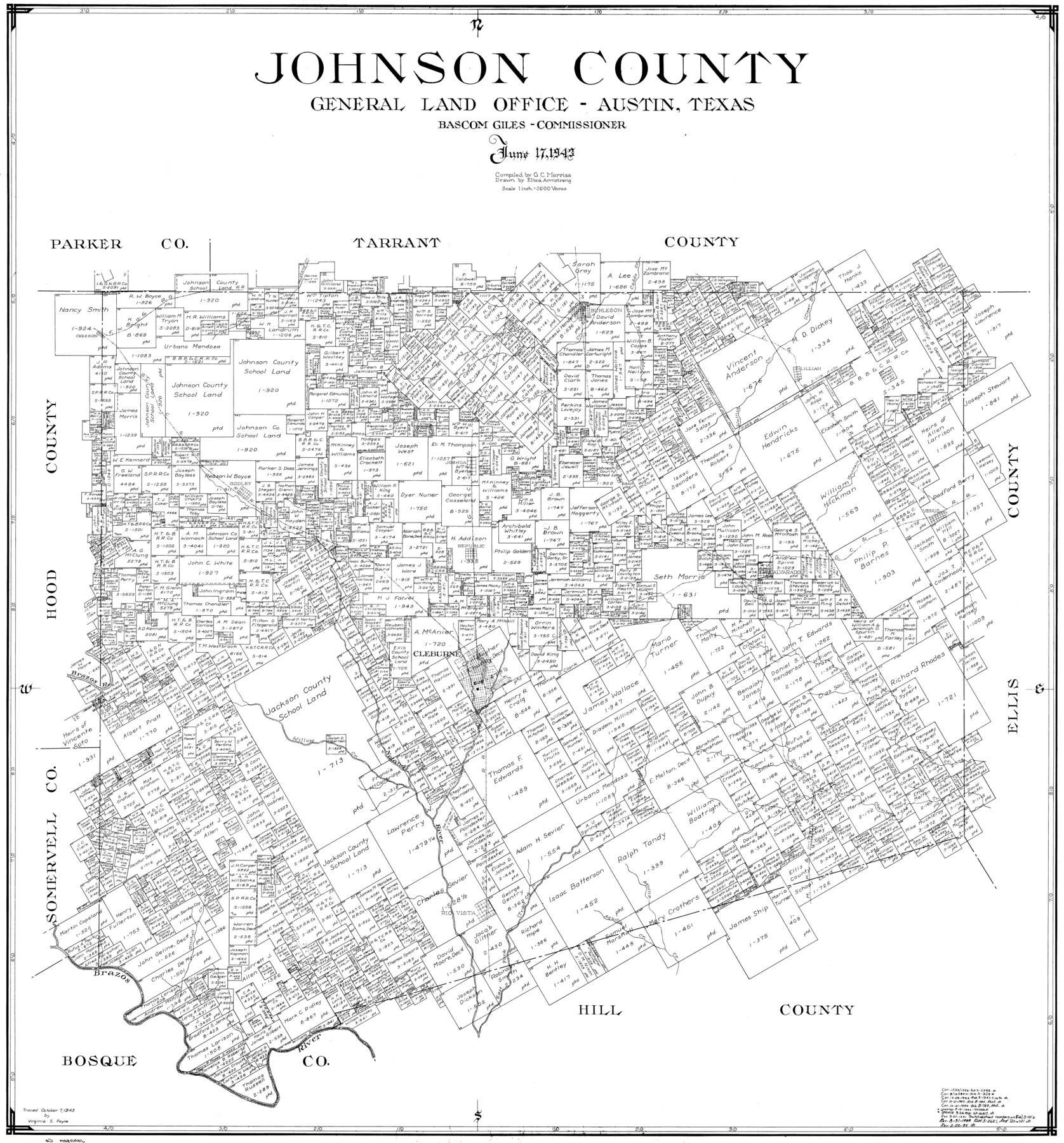
Johnson County
- 
                          Map/Doc
77332
 - 
                            Collection
General Map Collection
 - 
                            Object Dates
1943/6/17 (Creation Date)
 - 
                            People and Organizations
Eltea Armstrong (Draftsman)
G.C. Morriss (Compiler)
 - 
                            Counties
Johnson
 - 
                            Subjects
County
 - 
                            Height x Width
39.8 x 37.0 inches
101.1 x 94.0 cm
 
Part of: General Map Collection
            Floyd County Rolled Sketch 4


                                            Print $20.00                    
                                             -                         Digital $50.00                                    
                Floyd County Rolled Sketch 4
1917
Size 22.8 x 33.8 inches
                                Map/Doc 5879
            
            Galveston County Rolled Sketch 46A


                                            Print $20.00                    
                                             -                         Digital $50.00                                    
                Galveston County Rolled Sketch 46A
2000
Size 24.9 x 37.6 inches
                                Map/Doc 5982
            
            Potter County Rolled Sketch 11


                                            Print $20.00                    
                                             -                         Digital $50.00                                    
                Potter County Rolled Sketch 11
1986
Size 21.6 x 27.4 inches
                                Map/Doc 7324
            
            [Sketch for Mineral Application 16787 - Pecos River Bed, A. T. Freet]


                                            Print $40.00                    
                                             -                         Digital $50.00                                    
                [Sketch for Mineral Application 16787 - Pecos River Bed, A. T. Freet]
Size 19.6 x 70.7 inches
                                Map/Doc 65631
            
            Stonewall County Rolled Sketch 30


                                            Print $20.00                    
                                             -                         Digital $50.00                                    
                Stonewall County Rolled Sketch 30
Size 25.5 x 37.3 inches
                                Map/Doc 7874
            
            Calhoun County Working Sketch 8


                                            Print $20.00                    
                                             -                         Digital $50.00                                    
                Calhoun County Working Sketch 8
1943
Size 33.9 x 34.8 inches
                                Map/Doc 67824
            
            Presidio County Sketch File 3


                                            Print $6.00                    
                                             -                         Digital $50.00                                    
                Presidio County Sketch File 3
1941
Size 8.5 x 7.7 inches
                                Map/Doc 34423
            
            Val Verde County Sketch File 38


                                            Print $44.00                    
                                             -                         Digital $50.00                                    
                Val Verde County Sketch File 38
1938
Size 17.6 x 17.2 inches
                                Map/Doc 12579
            
            Navigation Maps of Gulf Intracoastal Waterway, Port Arthur to Brownsville, Texas


                                            Print $4.00                    
                                             -                         Digital $50.00                                    
                Navigation Maps of Gulf Intracoastal Waterway, Port Arthur to Brownsville, Texas
1951
Size 16.6 x 21.3 inches
                                Map/Doc 65438
            
            Stonewall County Working Sketch 28


                                            Print $20.00                    
                                             -                         Digital $50.00                                    
                Stonewall County Working Sketch 28
1976
Size 34.5 x 39.2 inches
                                Map/Doc 62335
            
            Current Miscellaneous File 94


                                            Print $3.00                    
                                             -                         Digital $50.00                                    
                Current Miscellaneous File 94
1851
Size 11.2 x 17.1 inches
                                Map/Doc 74268
            
            Wilbarger County Sketch File 5


                                            Print $4.00                    
                                             -                         Digital $50.00                                    
                Wilbarger County Sketch File 5
Size 9.3 x 7.9 inches
                                Map/Doc 40170
            You may also like
            Bell County Sketch File 12


                                            Print $4.00                    
                                             -                         Digital $50.00                                    
                Bell County Sketch File 12
1852
Size 8.1 x 12.5 inches
                                Map/Doc 14385
            
            Garza County Working Sketch 14


                                            Print $20.00                    
                                             -                         Digital $50.00                                    
                Garza County Working Sketch 14
1957
Size 24.3 x 35.0 inches
                                Map/Doc 63161
            
            Cameron Empresario Colony. September 28, 1828


                                            Print $20.00                    
                                    
                Cameron Empresario Colony. September 28, 1828
2020
Size 10.4 x 21.7 inches
                                Map/Doc 95987
            
            Johnson County Boundary File 2a


                                            Print $22.00                    
                                             -                         Digital $50.00                                    
                Johnson County Boundary File 2a
Size 9.0 x 8.3 inches
                                Map/Doc 55566
            
            Knox County Rolled Sketch 9


                                            Print $20.00                    
                                             -                         Digital $50.00                                    
                Knox County Rolled Sketch 9
Size 26.1 x 33.0 inches
                                Map/Doc 9407
            
            [Blocks DT, P, CK, C2, and D7]


                                            Print $20.00                    
                                             -                         Digital $50.00                                    
                [Blocks DT, P, CK, C2, and D7]
Size 23.6 x 9.6 inches
                                Map/Doc 91307
            
            Map of north end of Brazos Island


                                            Print $20.00                    
                                             -                         Digital $50.00                                    
                Map of north end of Brazos Island
1845
Size 24.3 x 18.3 inches
                                Map/Doc 72918
            
            St. Louis, Brownsville & Mexico Railway Location Map from Mile 40 to Mile 60


                                            Print $40.00                    
                                             -                         Digital $50.00                                    
                St. Louis, Brownsville & Mexico Railway Location Map from Mile 40 to Mile 60
1905
Size 20.3 x 136.1 inches
                                Map/Doc 89282
            
            [Sketch of part of G. & M. Block 5, G. & M. Block 4, Block M19 and Block 21W]


                                            Print $20.00                    
                                             -                         Digital $50.00                                    
                [Sketch of part of G. & M. Block 5, G. & M. Block 4, Block M19 and Block 21W]
Size 22.0 x 17.0 inches
                                Map/Doc 93113
            
            Hardin County Sketch File 12a


                                            Print $4.00                    
                                             -                         Digital $50.00                                    
                Hardin County Sketch File 12a
1866
Size 6.6 x 7.4 inches
                                Map/Doc 25118
            
            Tarrant County Sketch File 11


                                            Print $11.00                    
                                             -                         Digital $50.00                                    
                Tarrant County Sketch File 11
1859
Size 7.5 x 6.2 inches
                                Map/Doc 37698