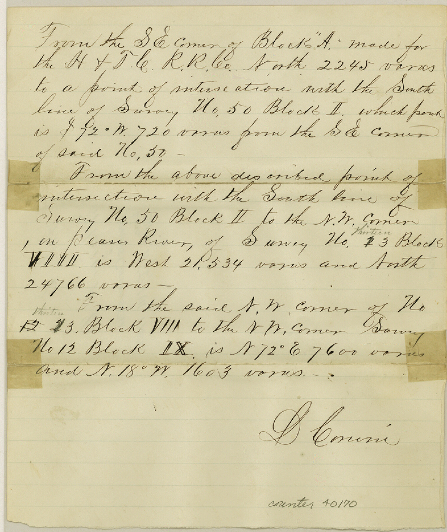
Wilbarger County Sketch File 5
[Field notes of a connecting line from the southeast corner of Block A, H. & T. C. R.R. Co. to various other sections and Blocks]
-
Map/Doc
40170
-
Collection
General Map Collection
-
People and Organizations
Dennis Corwin (Surveyor/Engineer)
-
Counties
Wilbarger Foard
-
Subjects
Surveying Sketch File
-
Height x Width
9.3 x 7.9 inches
23.6 x 20.1 cm
-
Medium
paper, manuscript
Part of: General Map Collection
San Patricio County Sketch File 15A

Print $4.00
San Patricio County Sketch File 15A
1883
Size 11.0 x 8.5 inches
Map/Doc 97195
Harris County Sketch File 61

Print $20.00
- Digital $50.00
Harris County Sketch File 61
1927
Size 19.4 x 16.7 inches
Map/Doc 11659
[Surveys in Austin's Colony along the San Bernardo River from the mouth of Peach Creek]
![209, [Surveys in Austin's Colony along the San Bernardo River from the mouth of Peach Creek], General Map Collection](https://historictexasmaps.com/wmedia_w700/maps/209.tif.jpg)
Print $20.00
- Digital $50.00
[Surveys in Austin's Colony along the San Bernardo River from the mouth of Peach Creek]
1821
Size 23.4 x 10.6 inches
Map/Doc 209
Limestone County State Real Property Sketch 1

Print $20.00
- Digital $50.00
Limestone County State Real Property Sketch 1
2010
Size 35.9 x 24.6 inches
Map/Doc 89570
Cottle County Sketch File A and B

Print $27.00
- Digital $50.00
Cottle County Sketch File A and B
Size 18.4 x 24.1 inches
Map/Doc 11200
The Making of America - Texas

The Making of America - Texas
1986
Size 20.7 x 27.3 inches
Map/Doc 96825
Eastland County Working Sketch 52

Print $20.00
- Digital $50.00
Eastland County Working Sketch 52
1982
Size 25.7 x 30.0 inches
Map/Doc 68833
Dimmit County Rolled Sketch 8

Print $20.00
- Digital $50.00
Dimmit County Rolled Sketch 8
1941
Size 30.0 x 29.6 inches
Map/Doc 5718
Flight Mission No. DCL-6C, Frame 134, Kenedy County

Print $20.00
- Digital $50.00
Flight Mission No. DCL-6C, Frame 134, Kenedy County
1943
Size 18.5 x 22.2 inches
Map/Doc 85964
Briscoe County Sketch File 12

Print $4.00
- Digital $50.00
Briscoe County Sketch File 12
1927
Size 11.2 x 8.8 inches
Map/Doc 16426
Cass County Rolled Sketch 7

Print $20.00
- Digital $50.00
Cass County Rolled Sketch 7
1957
Size 28.3 x 33.5 inches
Map/Doc 5413
Sketch B Showing the progress of Section No. 2

Print $20.00
- Digital $50.00
Sketch B Showing the progress of Section No. 2
1844
Size 25.3 x 27.7 inches
Map/Doc 97204
You may also like
Loving County Rolled Sketch 15

Print $20.00
- Digital $50.00
Loving County Rolled Sketch 15
2015
Size 36.2 x 24.4 inches
Map/Doc 93793
Map of Taylor County, Texas

Print $20.00
Map of Taylor County, Texas
1890
Size 22.0 x 18.1 inches
Map/Doc 93585
Working Sketch Armstrong County

Print $20.00
- Digital $50.00
Working Sketch Armstrong County
Size 29.3 x 21.2 inches
Map/Doc 90274
Gaines County Rolled Sketch 29

Print $20.00
- Digital $50.00
Gaines County Rolled Sketch 29
1990
Size 14.7 x 20.5 inches
Map/Doc 5942

Flight Mission No. BRE-2P, Frame 21, Nueces County

Print $20.00
- Digital $50.00
Flight Mission No. BRE-2P, Frame 21, Nueces County
1956
Size 18.5 x 22.3 inches
Map/Doc 86730
Titus County Sketch File 7

Print $4.00
- Digital $50.00
Titus County Sketch File 7
1853
Size 10.0 x 8.2 inches
Map/Doc 38142
Right of Way and Track Map, The Missouri, Kansas and Texas Ry. of Texas operated by the Missouri, Kansas and Texas Ry. of Texas, Henrietta Division

Print $40.00
- Digital $50.00
Right of Way and Track Map, The Missouri, Kansas and Texas Ry. of Texas operated by the Missouri, Kansas and Texas Ry. of Texas, Henrietta Division
1918
Size 25.4 x 56.3 inches
Map/Doc 64068
Guadalupe County Working Sketch 10

Print $20.00
- Digital $50.00
Guadalupe County Working Sketch 10
1966
Size 21.2 x 27.2 inches
Map/Doc 63319
Flight Mission No. CRK-3P, Frame 66, Refugio County

Print $20.00
- Digital $50.00
Flight Mission No. CRK-3P, Frame 66, Refugio County
1956
Size 18.6 x 22.4 inches
Map/Doc 86908
Cooke County Sketch File 41

Print $36.00
- Digital $50.00
Cooke County Sketch File 41
1928
Size 11.3 x 8.9 inches
Map/Doc 19308
Pecos County Working Sketch 29

Print $20.00
- Digital $50.00
Pecos County Working Sketch 29
1935
Size 24.3 x 24.0 inches
Map/Doc 71501