![65631, [Sketch for Mineral Application 16787 - Pecos River Bed, A. T. Freet], General Map Collection](https://historictexasmaps.com/wmedia_w1800h1800/maps/65631-1.tif.jpg)
[Sketch for Mineral Application 16787 - Pecos River Bed, A. T. Freet]
K-1-27 (a-d)
-
Map/Doc
65631
-
Collection
General Map Collection
-
Height x Width
19.6 x 70.7 inches
49.8 x 179.6 cm
Part of: General Map Collection
Flight Mission No. BRA-7M, Frame 148, Jefferson County

Print $20.00
- Digital $50.00
Flight Mission No. BRA-7M, Frame 148, Jefferson County
1953
Size 18.6 x 22.4 inches
Map/Doc 85542
Henderson County Working Sketch 36

Print $20.00
- Digital $50.00
Henderson County Working Sketch 36
1973
Size 27.5 x 19.0 inches
Map/Doc 66169
La Salle County Working Sketch 42

Print $20.00
- Digital $50.00
La Salle County Working Sketch 42
1976
Size 33.4 x 33.3 inches
Map/Doc 70343
Kinney County Working Sketch 45

Print $20.00
- Digital $50.00
Kinney County Working Sketch 45
1978
Size 28.6 x 26.5 inches
Map/Doc 70227
Brazoria County Sketch File 17

Print $24.00
- Digital $50.00
Brazoria County Sketch File 17
1914
Size 11.1 x 8.8 inches
Map/Doc 14988
Flight Mission No. DIX-8P, Frame 89, Aransas County

Print $20.00
- Digital $50.00
Flight Mission No. DIX-8P, Frame 89, Aransas County
1956
Size 18.7 x 22.4 inches
Map/Doc 83914
Lipscomb County Working Sketch 7

Print $20.00
- Digital $50.00
Lipscomb County Working Sketch 7
1982
Size 42.7 x 21.4 inches
Map/Doc 70583
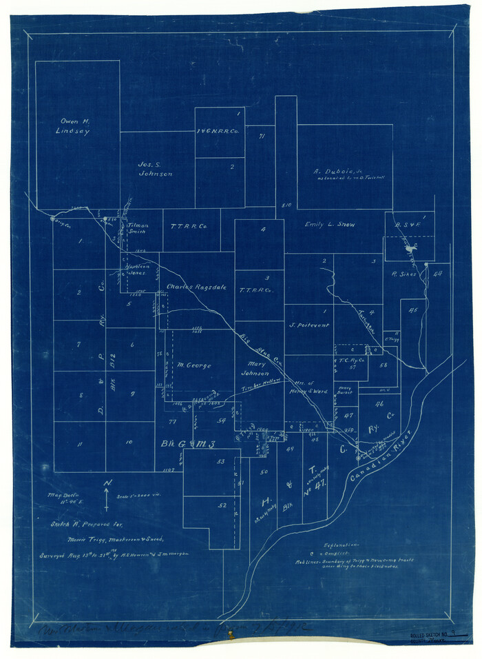
Knox County Rolled Sketch 9

Print $20.00
- Digital $50.00
Knox County Rolled Sketch 9
Size 26.1 x 33.0 inches
Map/Doc 9407
Johnson County Working Sketch 26

Print $20.00
- Digital $50.00
Johnson County Working Sketch 26
2005
Size 22.3 x 41.8 inches
Map/Doc 83574
Glasscock County Sketch File 24

Print $4.00
- Digital $50.00
Glasscock County Sketch File 24
1948
Size 15.5 x 9.1 inches
Map/Doc 24204
Flight Mission No. DQN-1K, Frame 82, Calhoun County

Print $20.00
- Digital $50.00
Flight Mission No. DQN-1K, Frame 82, Calhoun County
1953
Size 18.5 x 22.2 inches
Map/Doc 84167
Kimble County Sketch File 28

Print $20.00
- Digital $50.00
Kimble County Sketch File 28
Size 23.3 x 17.8 inches
Map/Doc 11927
You may also like
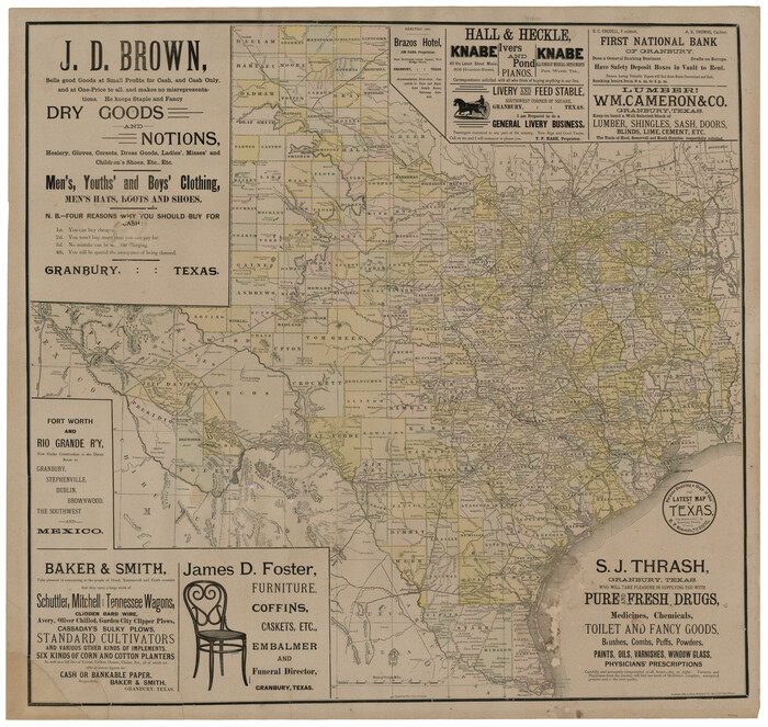
The Latest Map of Texas
Print $20.00
- Digital $50.00
The Latest Map of Texas
1889
Size 32.0 x 34.0 inches
Map/Doc 93422
Kleberg County Rolled Sketch 10-38

Print $20.00
- Digital $50.00
Kleberg County Rolled Sketch 10-38
1952
Size 36.5 x 30.8 inches
Map/Doc 9372
Mason County Working Sketch 3

Print $20.00
- Digital $50.00
Mason County Working Sketch 3
1911
Size 17.8 x 22.9 inches
Map/Doc 70839
Flight Mission No. DIX-8P, Frame 72, Aransas County

Print $20.00
- Digital $50.00
Flight Mission No. DIX-8P, Frame 72, Aransas County
1956
Size 18.7 x 22.4 inches
Map/Doc 83903
Moore County Rolled Sketch 9
Print $20.00
- Digital $50.00
Moore County Rolled Sketch 9
1911
Size 24.9 x 18.2 inches
Map/Doc 6827
Crockett County Sketch File 55

Print $6.00
- Digital $50.00
Crockett County Sketch File 55
1923
Size 11.2 x 8.5 inches
Map/Doc 19829
Flight Mission No. CRE-1R, Frame 65, Jackson County

Print $20.00
- Digital $50.00
Flight Mission No. CRE-1R, Frame 65, Jackson County
1956
Size 18.6 x 22.3 inches
Map/Doc 85328
Flight Mission No. BRA-16M, Frame 65, Jefferson County

Print $20.00
- Digital $50.00
Flight Mission No. BRA-16M, Frame 65, Jefferson County
1953
Size 18.7 x 22.4 inches
Map/Doc 85682
Jeff Davis County Rolled Sketch 45

Print $40.00
- Digital $50.00
Jeff Davis County Rolled Sketch 45
2005
Size 91.3 x 44.0 inches
Map/Doc 87207


Hardin County Rolled Sketch 10

Print $20.00
- Digital $50.00
Hardin County Rolled Sketch 10
1948
Size 23.7 x 33.0 inches
Map/Doc 6082