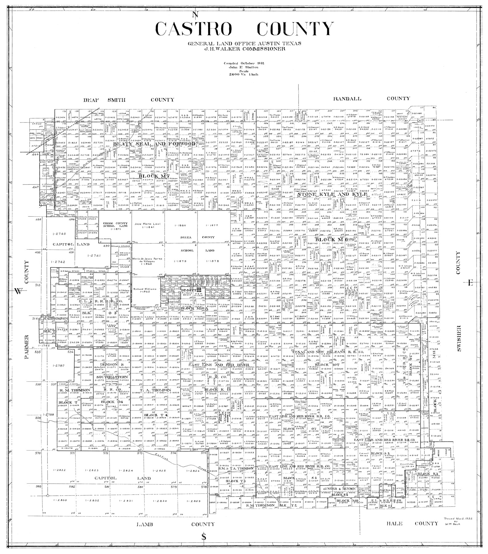
Castro County
-
Map/Doc
77234
-
Collection
General Map Collection
-
Object Dates
1932 (Creation Date)
-
People and Organizations
John E. Shelton Jr. (Compiler)
-
Counties
Castro
-
Subjects
County
-
Height x Width
39.2 x 34.4 inches
99.6 x 87.4 cm
Part of: General Map Collection
Edwards County Working Sketch 59

Print $20.00
- Digital $50.00
Edwards County Working Sketch 59
1954
Size 22.7 x 22.4 inches
Map/Doc 68935
Washington County Working Sketch 4

Print $20.00
- Digital $50.00
Washington County Working Sketch 4
1992
Size 28.2 x 25.2 inches
Map/Doc 72365
Red River County Sketch File 3

Print $4.00
- Digital $50.00
Red River County Sketch File 3
Size 10.4 x 8.3 inches
Map/Doc 35098
Travis County Sketch File 70

Print $26.00
- Digital $50.00
Travis County Sketch File 70
1961
Size 14.4 x 8.8 inches
Map/Doc 38453
Kerr County Working Sketch 25

Print $20.00
- Digital $50.00
Kerr County Working Sketch 25
Size 21.5 x 28.5 inches
Map/Doc 70056
Edwards County Working Sketch 108

Print $40.00
- Digital $50.00
Edwards County Working Sketch 108
1972
Size 61.2 x 37.1 inches
Map/Doc 68984

Gulf Coast of the United States, Key West to Rio Grande

Print $20.00
- Digital $50.00
Gulf Coast of the United States, Key West to Rio Grande
1892
Size 27.5 x 18.3 inches
Map/Doc 72669
Map and Profile No. 1 from the Red River to the Rio Grande; from explorations and surveys made under the direction of the Hon. Jefferson Davis, Secretary of War by Captain John Pope, Corps. Topl Engrs.

Print $40.00
- Digital $50.00
Map and Profile No. 1 from the Red River to the Rio Grande; from explorations and surveys made under the direction of the Hon. Jefferson Davis, Secretary of War by Captain John Pope, Corps. Topl Engrs.
Size 30.2 x 59.9 inches
Map/Doc 95176
Map of North America engraved to illustrate Mitchell's new intermediate geography

Print $20.00
- Digital $50.00
Map of North America engraved to illustrate Mitchell's new intermediate geography
1885
Size 12.2 x 9.0 inches
Map/Doc 93512
Kleberg County NRC Article 33.136 Sketch 1

Print $143.00
- Digital $50.00
Kleberg County NRC Article 33.136 Sketch 1
2000
Size 18.5 x 23.6 inches
Map/Doc 6555
Denton County Working Sketch 10

Print $20.00
- Digital $50.00
Denton County Working Sketch 10
1960
Size 30.2 x 25.0 inches
Map/Doc 68615
You may also like
Val Verde County Sketch File AA3

Print $20.00
- Digital $50.00
Val Verde County Sketch File AA3
1924
Size 19.5 x 20.6 inches
Map/Doc 12540
Newton County

Print $40.00
- Digital $50.00
Newton County
1946
Size 48.7 x 42.6 inches
Map/Doc 73250
Flight Mission No. BQY-4M, Frame 61, Harris County

Print $20.00
- Digital $50.00
Flight Mission No. BQY-4M, Frame 61, Harris County
1953
Size 18.7 x 22.5 inches
Map/Doc 85270
General Highway Map. Detail of Cities and Towns in Bowie County, Texas

Print $20.00
General Highway Map. Detail of Cities and Towns in Bowie County, Texas
1961
Size 18.0 x 24.8 inches
Map/Doc 79381
Galveston Harbor and Channel, Texas - Rehabilitation of Beachfront Groins - Present Construction

Print $4.00
- Digital $50.00
Galveston Harbor and Channel, Texas - Rehabilitation of Beachfront Groins - Present Construction
1967
Size 15.6 x 21.0 inches
Map/Doc 73619
Hudspeth County Rolled Sketch 59

Print $40.00
- Digital $50.00
Hudspeth County Rolled Sketch 59
Size 69.2 x 42.8 inches
Map/Doc 9224
Webb County Working Sketch 83

Print $20.00
- Digital $50.00
Webb County Working Sketch 83
1980
Size 20.7 x 34.9 inches
Map/Doc 72450
Roberts County

Print $20.00
- Digital $50.00
Roberts County
1884
Size 20.3 x 18.2 inches
Map/Doc 3992
United States - Gulf Coast - From Latitude 26° 33' to the Rio Grande Texas

Print $20.00
- Digital $50.00
United States - Gulf Coast - From Latitude 26° 33' to the Rio Grande Texas
1913
Size 27.9 x 18.4 inches
Map/Doc 72834
Lubbock County Working Sketch 1

Print $20.00
- Digital $50.00
Lubbock County Working Sketch 1
Size 8.7 x 35.3 inches
Map/Doc 70660
Flight Mission No. DQN-1K, Frame 81, Calhoun County

Print $20.00
- Digital $50.00
Flight Mission No. DQN-1K, Frame 81, Calhoun County
1953
Size 18.4 x 22.1 inches
Map/Doc 84166
Lampasas County Boundary File 11

Print $4.00
- Digital $50.00
Lampasas County Boundary File 11
Size 14.0 x 8.6 inches
Map/Doc 56189