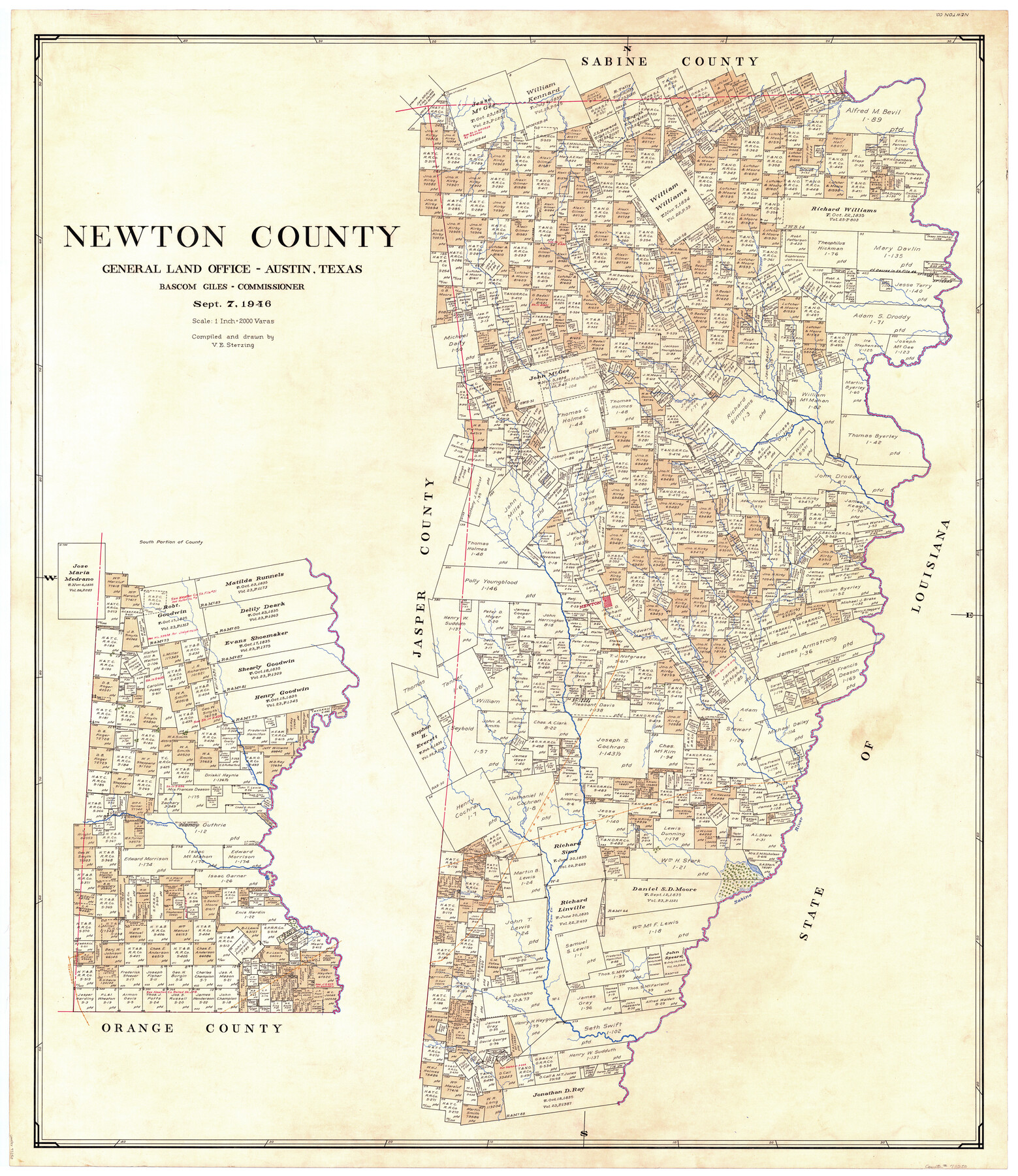
Newton County
-
Map/Doc
73250
-
Collection
General Map Collection
-
Object Dates
1946/9/7 (Creation Date)
-
People and Organizations
Texas General Land Office (Publisher)
Bascom Giles (GLO Commissioner)
Victor E. Sterzing (Compiler)
Victor E. Sterzing (Draftsman)
-
Counties
Newton
-
Subjects
County
-
Height x Width
48.7 x 42.6 inches
123.7 x 108.2 cm
-
Comments
Hand lettered.
Note on reverse side: "Compilation completed September 7, 1946. Inking completed April 9, 1947. Tracing completed August 18, 1947. Placed in official use August 21, 1947. Replaced [on sticks] by copy August 21, 1947." -
Features
Big Cow Creek
Middle Creek
Quicksand Creek
Davis Creek
Thicketty [sic] Creek
GC&SF
O&NW
Sabine River
Trout Creek
Huckelberry Creek
Slaydon's Creek
Yellow Bayou
Caney Creek
Nichols Creek
White Oak Creek
Big Cypress Creek
KCS
Weeks Creek
Rock Creek
Bee Tree Creek
Magnolia Creek
Mill Creek
Buck Creek
Indian Creek
McGraws Creek
Deer Creek
Sandy Creek
Cat Creek
Clear Creek
Little Cow Creek
Swindler Creek
Westerlands Creek
Newton
Underwood Creek
Part of: General Map Collection
Sutton County Rolled Sketch 69

Print $20.00
- Digital $50.00
Sutton County Rolled Sketch 69
Size 39.7 x 36.6 inches
Map/Doc 9981
Rains County Sketch File 6

Print $4.00
- Digital $50.00
Rains County Sketch File 6
Size 8.0 x 9.1 inches
Map/Doc 34954
Floyd County Sketch File 24

Print $6.00
- Digital $50.00
Floyd County Sketch File 24
1915
Size 9.0 x 14.5 inches
Map/Doc 22780
Dimmit County Sketch File 60

Print $4.00
- Digital $50.00
Dimmit County Sketch File 60
1991
Size 14.2 x 8.8 inches
Map/Doc 21206
Harrison County Working Sketch 2

Print $20.00
- Digital $50.00
Harrison County Working Sketch 2
1940
Size 40.3 x 36.0 inches
Map/Doc 66022
Kent County Boundary File 4a

Print $18.00
- Digital $50.00
Kent County Boundary File 4a
Size 14.2 x 8.5 inches
Map/Doc 55838
Tarrant County Sketch File 36

Print $56.00
- Digital $50.00
Tarrant County Sketch File 36
2018
Size 11.0 x 8.5 inches
Map/Doc 95395
Pecos County Sketch File 77

Print $4.00
- Digital $50.00
Pecos County Sketch File 77
1943
Size 11.2 x 8.7 inches
Map/Doc 33909
Eastland County Working Sketch 17

Print $20.00
- Digital $50.00
Eastland County Working Sketch 17
1919
Size 18.3 x 16.2 inches
Map/Doc 68798
Zavala County Sketch File 9

Print $20.00
- Digital $50.00
Zavala County Sketch File 9
1884
Size 29.1 x 15.9 inches
Map/Doc 12727
Morris County Rolled Sketch 2A

Print $20.00
- Digital $50.00
Morris County Rolled Sketch 2A
Size 24.0 x 18.7 inches
Map/Doc 10272
Red River County Working Sketch 81-3

Print $20.00
- Digital $50.00
Red River County Working Sketch 81-3
1987
Size 17.5 x 21.5 inches
Map/Doc 72066
You may also like
A Map of Sterling County

Print $20.00
- Digital $50.00
A Map of Sterling County
1919
Size 33.3 x 21.6 inches
Map/Doc 4054
Marion County Working Sketch 9

Print $20.00
- Digital $50.00
Marion County Working Sketch 9
1940
Size 23.5 x 25.5 inches
Map/Doc 70784
Map of the country adjacent to the left bank of the Rio Grande below Matamoros

Print $20.00
- Digital $50.00
Map of the country adjacent to the left bank of the Rio Grande below Matamoros
1847
Size 18.3 x 27.5 inches
Map/Doc 72870
Whitharral Located on West Half of Labor 11, Capitol League 716 Hockley County, Texas

Print $20.00
- Digital $50.00
Whitharral Located on West Half of Labor 11, Capitol League 716 Hockley County, Texas
Size 17.5 x 20.9 inches
Map/Doc 92261
Matagorda County Sketch File 35

Print $8.00
- Digital $50.00
Matagorda County Sketch File 35
1951
Size 11.1 x 8.8 inches
Map/Doc 30823
Burleson County Working Sketch 3

Print $20.00
- Digital $50.00
Burleson County Working Sketch 3
1979
Size 26.5 x 22.5 inches
Map/Doc 67722
Red River Co.

Print $20.00
- Digital $50.00
Red River Co.
1897
Size 46.8 x 36.0 inches
Map/Doc 16796
Henderson County Working Sketch 39

Print $20.00
- Digital $50.00
Henderson County Working Sketch 39
1982
Size 24.3 x 19.0 inches
Map/Doc 66172
Sutton County Boundary File 2

Print $22.00
- Digital $50.00
Sutton County Boundary File 2
Size 14.4 x 8.9 inches
Map/Doc 59004
Falls County Working Sketch 1

Print $20.00
- Digital $50.00
Falls County Working Sketch 1
1922
Size 23.0 x 33.1 inches
Map/Doc 69176
Mason County Rolled Sketch 7

Print $20.00
- Digital $50.00
Mason County Rolled Sketch 7
1986
Size 24.3 x 20.3 inches
Map/Doc 6679
Flight Mission No. BRA-8M, Frame 144, Jefferson County

Print $20.00
- Digital $50.00
Flight Mission No. BRA-8M, Frame 144, Jefferson County
1953
Size 18.8 x 22.6 inches
Map/Doc 85636