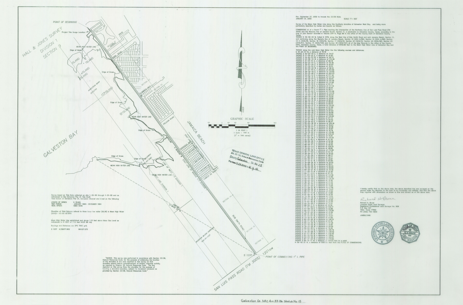
Galveston County NRC Article 33.136 Sketch 15
A Survey of the Mean High Water Line Along the Southerly Shoreline of Galveston West Bay
-
Map/Doc
77046
-
Collection
General Map Collection
-
Object Dates
2002/9/27 (Creation Date)
2002/11/22 (File Date)
-
People and Organizations
Richard H. Bruce, L.S.L.S. (Printer)
Richard H. Bruce (Surveyor/Engineer)
-
Counties
Galveston
-
Subjects
Surveying CBS
-
Height x Width
23.0 x 35.0 inches
58.4 x 88.9 cm
-
Medium
multi-page, multi-format
-
Comments
Survey located about 14 miles South 56 degrees West of Galveston, Texas.
One or more items in this file were formerly filed in another file. They have been reunited in this file with their original grouping. The old name on these sheets has been cros
Part of: General Map Collection
Hardin County Rolled Sketch 7

Print $20.00
- Digital $50.00
Hardin County Rolled Sketch 7
1947
Size 33.4 x 42.4 inches
Map/Doc 6080
Maverick County Working Sketch 1

Print $20.00
- Digital $50.00
Maverick County Working Sketch 1
1906
Size 11.5 x 11.1 inches
Map/Doc 70893
Presidio County Rolled Sketch 91

Print $20.00
- Digital $50.00
Presidio County Rolled Sketch 91
Size 15.1 x 29.4 inches
Map/Doc 7376
Flight Mission No. CRC-5R, Frame 25, Chambers County

Print $20.00
- Digital $50.00
Flight Mission No. CRC-5R, Frame 25, Chambers County
1956
Size 18.9 x 22.4 inches
Map/Doc 84947
Hunt County Sketch File 20

Print $4.00
- Digital $50.00
Hunt County Sketch File 20
1853
Size 8.3 x 7.9 inches
Map/Doc 27120
Brazos Santiago, Texas

Print $20.00
- Digital $50.00
Brazos Santiago, Texas
1900
Size 18.3 x 26.7 inches
Map/Doc 73032

Map of Travis County

Print $20.00
- Digital $50.00
Map of Travis County
Size 23.5 x 24.2 inches
Map/Doc 4090
Hemphill County Working Sketch 29

Print $40.00
- Digital $50.00
Hemphill County Working Sketch 29
1974
Size 61.7 x 43.4 inches
Map/Doc 66124
Jeff Davis County Rolled Sketch 28

Print $20.00
- Digital $50.00
Jeff Davis County Rolled Sketch 28
1977
Size 41.0 x 30.5 inches
Map/Doc 6376
Crockett County Rolled Sketch 88J

Print $40.00
- Digital $50.00
Crockett County Rolled Sketch 88J
1973
Size 42.7 x 57.4 inches
Map/Doc 8734
Flight Mission No. CLL-4N, Frame 39, Willacy County

Print $20.00
- Digital $50.00
Flight Mission No. CLL-4N, Frame 39, Willacy County
1954
Size 18.3 x 22.0 inches
Map/Doc 87112
You may also like
[Blocks T1, T2, T3, and Vicinity]
![90983, [Blocks T1, T2, T3, and Vicinity], Twichell Survey Records](https://historictexasmaps.com/wmedia_w700/maps/90983-1.tif.jpg)
Print $20.00
- Digital $50.00
[Blocks T1, T2, T3, and Vicinity]
Size 30.3 x 33.6 inches
Map/Doc 90983
General Highway Map. Detail of Cities and Towns in Smith County, Texas. City Map, Tyler and vicinity, Smith County, Texas

Print $20.00
General Highway Map. Detail of Cities and Towns in Smith County, Texas. City Map, Tyler and vicinity, Smith County, Texas
1961
Size 18.2 x 24.9 inches
Map/Doc 79657
Webb County Rolled Sketch 57

Print $20.00
- Digital $50.00
Webb County Rolled Sketch 57
Size 23.5 x 32.2 inches
Map/Doc 8209
Hamilton County Working Sketch 8

Print $20.00
- Digital $50.00
Hamilton County Working Sketch 8
1943
Size 27.6 x 28.5 inches
Map/Doc 63346
Matagorda County Rolled Sketch 35

Print $20.00
- Digital $50.00
Matagorda County Rolled Sketch 35
1903
Size 18.6 x 38.0 inches
Map/Doc 6696
Jones County Sketch File 16

Print $20.00
- Digital $50.00
Jones County Sketch File 16
1945
Size 23.7 x 19.0 inches
Map/Doc 11901
Yoakum-Terry County Sketch

Print $20.00
- Digital $50.00
Yoakum-Terry County Sketch
Size 9.6 x 27.5 inches
Map/Doc 92932
Duval County Rolled Sketch 32

Print $20.00
- Digital $50.00
Duval County Rolled Sketch 32
Size 38.5 x 37.3 inches
Map/Doc 8817
Working Sketch of Surveys in Presidio County in the area east of Shafter, Texas

Print $20.00
- Digital $50.00
Working Sketch of Surveys in Presidio County in the area east of Shafter, Texas
1947
Size 37.5 x 40.1 inches
Map/Doc 89889
Hill County Working Sketch 1

Print $20.00
- Digital $50.00
Hill County Working Sketch 1
1939
Size 11.0 x 17.8 inches
Map/Doc 66187
Map of the country in the vicinity of San Antonio de Bexar reduced in part from the county map of Bexar with additions by J. Edmd. Blake, 1st Lieut Topl. Engs.

Print $20.00
- Digital $50.00
Map of the country in the vicinity of San Antonio de Bexar reduced in part from the county map of Bexar with additions by J. Edmd. Blake, 1st Lieut Topl. Engs.
1845
Size 18.1 x 25.7 inches
Map/Doc 72722
Wood County Boundary File 4

Print $6.00
- Digital $50.00
Wood County Boundary File 4
Size 12.1 x 8.1 inches
Map/Doc 60167