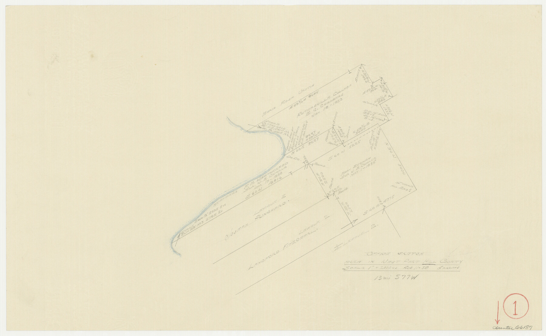
Hill County Working Sketch 1
-
Map/Doc
66187
-
Collection
General Map Collection
-
Object Dates
8/11/1939 (Creation Date)
-
People and Organizations
William Shirriffs (Draftsman)
-
Counties
Hill
-
Subjects
Surveying Working Sketch
-
Height x Width
11.0 x 17.8 inches
27.9 x 45.2 cm
-
Scale
1" = 2000 varas
Part of: General Map Collection
Sterling County

Print $20.00
- Digital $50.00
Sterling County
1926
Size 47.8 x 35.2 inches
Map/Doc 16820
Flight Mission No. CLL-1N, Frame 196, Willacy County

Print $20.00
- Digital $50.00
Flight Mission No. CLL-1N, Frame 196, Willacy County
1954
Size 18.5 x 22.2 inches
Map/Doc 87066
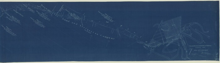
St. Louis, Brownsville & Mexico Railway Location Map from Mile 120 to Rio Grande
Print $40.00
- Digital $50.00
St. Louis, Brownsville & Mexico Railway Location Map from Mile 120 to Rio Grande
1905
Size 19.6 x 67.7 inches
Map/Doc 64170
Map of the River Sabine from its mouth on the Gulf of Mexico in the Sea to Logan's Ferry in Latitude 31°58'24" North

Print $20.00
- Digital $50.00
Map of the River Sabine from its mouth on the Gulf of Mexico in the Sea to Logan's Ferry in Latitude 31°58'24" North
1842
Size 47.9 x 30.6 inches
Map/Doc 87150
Pecos County Working Sketch 68

Print $20.00
- Digital $50.00
Pecos County Working Sketch 68
1955
Size 41.4 x 24.0 inches
Map/Doc 71540
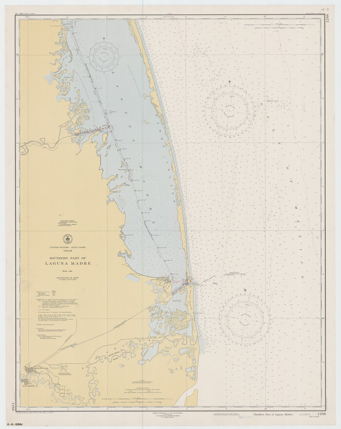
Southern Part of Laguna Madre
Print $20.00
- Digital $50.00
Southern Part of Laguna Madre
1949
Size 44.5 x 35.4 inches
Map/Doc 73535
Jim Hogg County Working Sketch 5

Print $20.00
- Digital $50.00
Jim Hogg County Working Sketch 5
1941
Size 40.8 x 41.0 inches
Map/Doc 66591
Eastland County Working Sketch 46

Print $20.00
- Digital $50.00
Eastland County Working Sketch 46
1980
Size 33.4 x 36.6 inches
Map/Doc 68827
Reagan County Boundary File 1c

Print $56.00
- Digital $50.00
Reagan County Boundary File 1c
Size 9.2 x 8.2 inches
Map/Doc 58171
Reagan County Working Sketch 47

Print $20.00
- Digital $50.00
Reagan County Working Sketch 47
1987
Size 23.9 x 43.8 inches
Map/Doc 71890
Freestone County Working Sketch 18

Print $20.00
- Digital $50.00
Freestone County Working Sketch 18
1980
Size 43.3 x 46.9 inches
Map/Doc 69260
Travis County State Real Property Sketch 2

Print $20.00
- Digital $50.00
Travis County State Real Property Sketch 2
1986
Size 34.0 x 35.5 inches
Map/Doc 61693
You may also like


Flight Mission No. DQO-8K, Frame 71, Galveston County

Print $20.00
- Digital $50.00
Flight Mission No. DQO-8K, Frame 71, Galveston County
1952
Size 18.6 x 22.4 inches
Map/Doc 85175
Clay County Boundary File 18a

Print $80.00
- Digital $50.00
Clay County Boundary File 18a
Size 65.3 x 17.3 inches
Map/Doc 51443
Matagorda Light to Aransas Pass

Print $20.00
- Digital $50.00
Matagorda Light to Aransas Pass
1981
Size 36.6 x 44.5 inches
Map/Doc 73402
Red River County Working Sketch 78

Print $20.00
- Digital $50.00
Red River County Working Sketch 78
1982
Size 40.6 x 36.8 inches
Map/Doc 72061
Presidio County Sketch File G

Print $6.00
- Digital $50.00
Presidio County Sketch File G
1913
Size 9.7 x 17.0 inches
Map/Doc 34429
General Highway Map, Kenedy County, Texas

Print $20.00
General Highway Map, Kenedy County, Texas
1961
Size 18.0 x 24.6 inches
Map/Doc 79446
Angelina County Working Sketch 33

Print $20.00
- Digital $50.00
Angelina County Working Sketch 33
1955
Size 22.7 x 24.2 inches
Map/Doc 67116
Flight Mission No. CRC-1R, Frame 38, Chambers County

Print $20.00
- Digital $50.00
Flight Mission No. CRC-1R, Frame 38, Chambers County
1956
Size 18.7 x 22.4 inches
Map/Doc 84706
Chambers County Sketch File 44

Print $36.00
- Digital $50.00
Chambers County Sketch File 44
Size 13.9 x 8.7 inches
Map/Doc 17735
La Salle County Sketch File 25

Print $4.00
- Digital $50.00
La Salle County Sketch File 25
Size 7.5 x 14.2 inches
Map/Doc 29549