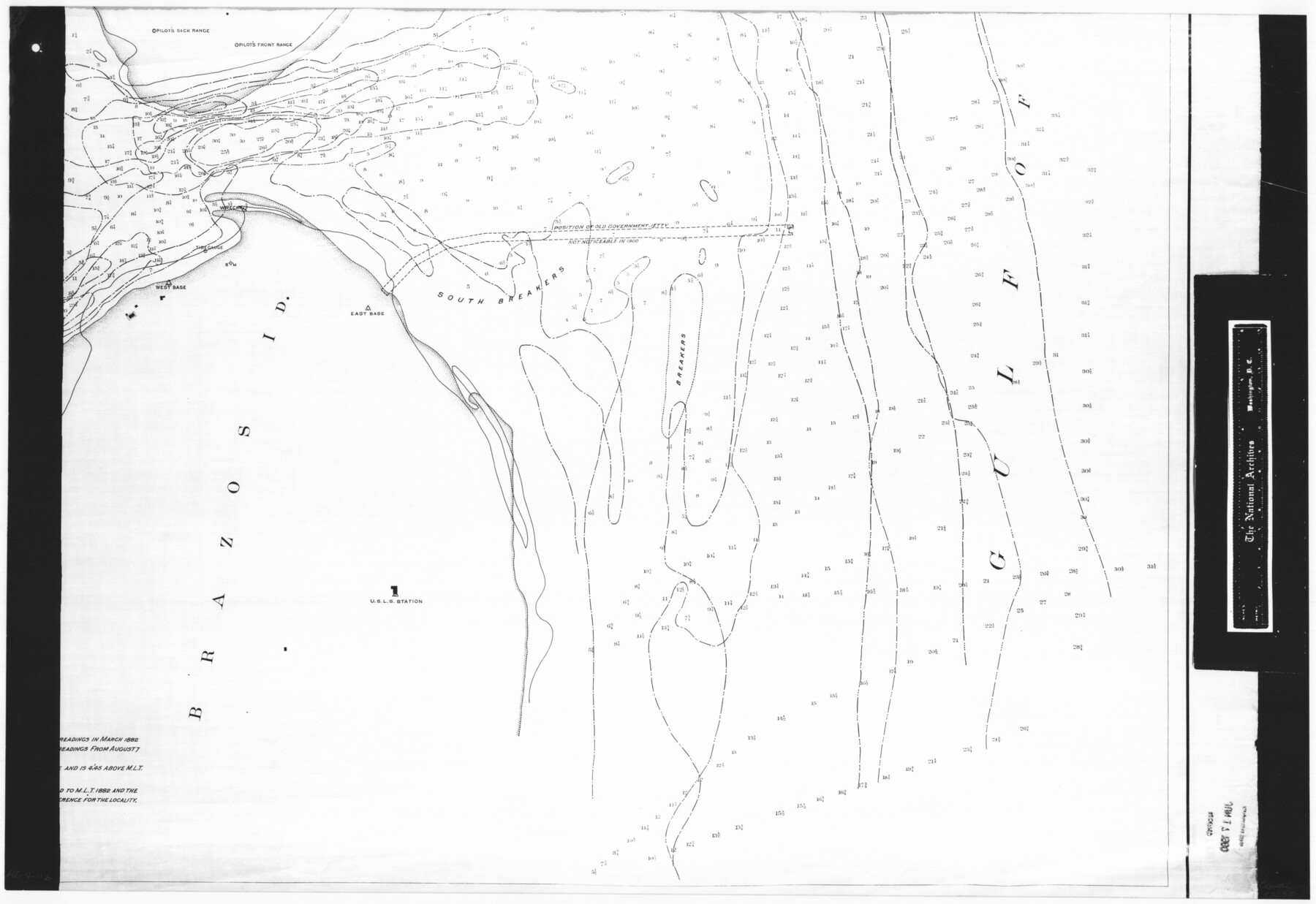
Brazos Santiago, Texas
RL-4-11b
-
Map/Doc
73032
-
Collection
General Map Collection
-
Object Dates
1900 (Creation Date)
-
People and Organizations
U. S. Army Corps of Engineers (Publisher)
J. Boyle (Surveyor/Engineer)
J.Y. Johnson (Surveyor/Engineer)
R.B. Talfor (Surveyor/Engineer)
-
Subjects
Nautical Charts
-
Height x Width
18.3 x 26.7 inches
46.5 x 67.8 cm
-
Comments
B/W photostat copy from National Archives in multiple pieces.
Part of: General Map Collection
Galveston County NRC Article 33.136 Sketch 68

Print $34.00
- Digital $50.00
Galveston County NRC Article 33.136 Sketch 68
2008
Size 24.0 x 36.0 inches
Map/Doc 94840
Railroad and County Map of Texas

Print $20.00
- Digital $50.00
Railroad and County Map of Texas
1908
Size 42.7 x 44.7 inches
Map/Doc 2141
Ellis County Boundary File 3c

Print $130.00
- Digital $50.00
Ellis County Boundary File 3c
Size 10.9 x 8.7 inches
Map/Doc 52972
Wichita County Rolled Sketch 5

Print $20.00
- Digital $50.00
Wichita County Rolled Sketch 5
Size 24.1 x 39.2 inches
Map/Doc 8242
Flight Mission No. CRC-4R, Frame 153, Chambers County

Print $20.00
- Digital $50.00
Flight Mission No. CRC-4R, Frame 153, Chambers County
1956
Size 18.7 x 22.4 inches
Map/Doc 84916
Hall County Sketch File 15

Print $6.00
- Digital $50.00
Hall County Sketch File 15
Size 5.7 x 16.9 inches
Map/Doc 24814
Harris County Rolled Sketch 97

Print $20.00
- Digital $50.00
Harris County Rolled Sketch 97
Size 18.8 x 23.6 inches
Map/Doc 6135
Morris County Rolled Sketch 2A

Print $20.00
- Digital $50.00
Morris County Rolled Sketch 2A
Size 24.3 x 19.2 inches
Map/Doc 10255
Terrell County Working Sketch 10

Print $20.00
- Digital $50.00
Terrell County Working Sketch 10
1924
Size 28.0 x 25.9 inches
Map/Doc 62159
Uvalde County Working Sketch 28

Print $20.00
- Digital $50.00
Uvalde County Working Sketch 28
1957
Size 25.9 x 21.5 inches
Map/Doc 72098
Hudspeth County Working Sketch 34

Print $40.00
- Digital $50.00
Hudspeth County Working Sketch 34
1977
Size 63.1 x 37.3 inches
Map/Doc 66319
Hamilton County Working Sketch 28

Print $20.00
- Digital $50.00
Hamilton County Working Sketch 28
1976
Size 27.7 x 33.2 inches
Map/Doc 63366
You may also like
McCulloch County Working Sketch 18

Print $20.00
- Digital $50.00
McCulloch County Working Sketch 18
1997
Size 42.9 x 32.8 inches
Map/Doc 70693
Austin County Working Sketch 9

Print $20.00
- Digital $50.00
Austin County Working Sketch 9
1996
Size 34.4 x 32.0 inches
Map/Doc 67250
Webb County Sketch File 13-1

Print $6.00
- Digital $50.00
Webb County Sketch File 13-1
Size 8.5 x 7.8 inches
Map/Doc 39804
Sudan Cemetery Sudan, Texas

Print $20.00
- Digital $50.00
Sudan Cemetery Sudan, Texas
1925
Size 24.1 x 28.2 inches
Map/Doc 92403
Goliad County Sketch File X

Print $10.00
- Digital $50.00
Goliad County Sketch File X
1893
Size 8.3 x 12.8 inches
Map/Doc 24332
Flight Mission No. CRE-2R, Frame 168, Jackson County

Print $20.00
- Digital $50.00
Flight Mission No. CRE-2R, Frame 168, Jackson County
1956
Size 18.5 x 22.3 inches
Map/Doc 85378
Flight Mission No. CLL-4N, Frame 37, Willacy County

Print $20.00
- Digital $50.00
Flight Mission No. CLL-4N, Frame 37, Willacy County
1954
Size 18.4 x 22.1 inches
Map/Doc 87110
Brooks County Working Sketch 6

Print $20.00
- Digital $50.00
Brooks County Working Sketch 6
1917
Size 28.6 x 15.7 inches
Map/Doc 67790
Webb County Sketch File 11a

Print $4.00
- Digital $50.00
Webb County Sketch File 11a
1883
Size 11.2 x 8.7 inches
Map/Doc 39779
Kerr County Boundary File 1

Print $4.00
- Digital $50.00
Kerr County Boundary File 1
Size 12.7 x 8.1 inches
Map/Doc 55982
Map of Glasscock County, Texas

Print $20.00
Map of Glasscock County, Texas
Size 22.7 x 18.3 inches
Map/Doc 88943
Panola County Rolled Sketch 2

Print $20.00
- Digital $50.00
Panola County Rolled Sketch 2
1944
Size 20.7 x 27.0 inches
Map/Doc 7197