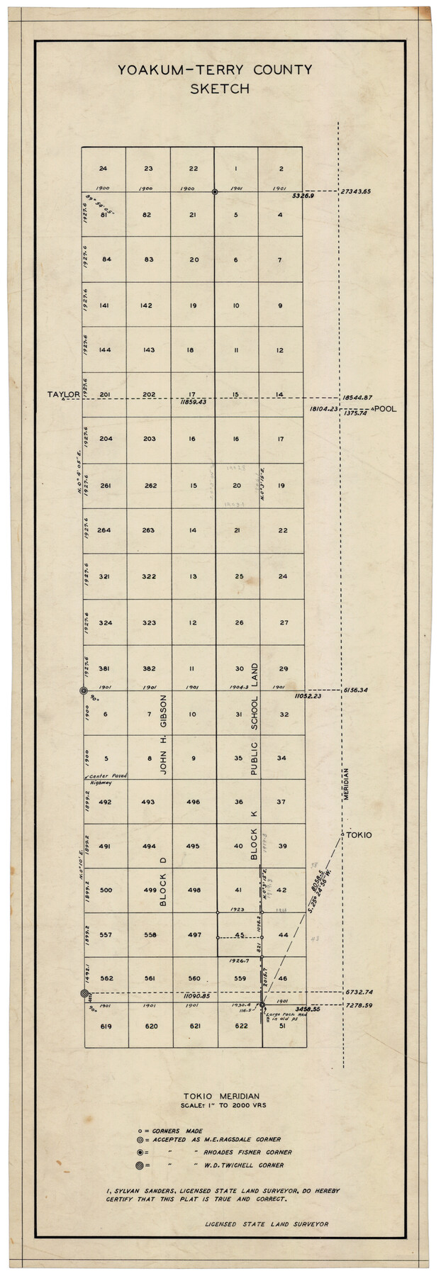
Yoakum-Terry County Sketch
-
Map/Doc
92932
-
Collection
Twichell Survey Records
-
People and Organizations
Sylvan Sanders (Surveyor/Engineer)
-
Counties
Yoakum Terry
-
Height x Width
9.6 x 27.5 inches
24.4 x 69.9 cm
Part of: Twichell Survey Records
Brazos River Conservation and Reclamation District Official Boundary Line Survey

Print $20.00
- Digital $50.00
Brazos River Conservation and Reclamation District Official Boundary Line Survey
Size 37.2 x 24.7 inches
Map/Doc 90183
[Ector County Line Descriptions]
![92636, [Ector County Line Descriptions], Twichell Survey Records](https://historictexasmaps.com/wmedia_w700/maps/92636-1.tif.jpg)
Print $20.00
- Digital $50.00
[Ector County Line Descriptions]
Size 37.2 x 44.2 inches
Map/Doc 92636
Working Sketch in Bastrop County

Print $20.00
- Digital $50.00
Working Sketch in Bastrop County
1921
Size 14.4 x 22.9 inches
Map/Doc 90205
[Sketch of area south of Runnels County School Land League No. 3]
![91544, [Sketch of area south of Runnels County School Land League No. 3], Twichell Survey Records](https://historictexasmaps.com/wmedia_w700/maps/91544-1.tif.jpg)
Print $2.00
- Digital $50.00
[Sketch of area south of Runnels County School Land League No. 3]
Size 11.9 x 9.2 inches
Map/Doc 91544
[Blocks GG, 1, 29, A2, Archer County School Land Sections 1,2,3,4]
![92439, [Blocks GG, 1, 29, A2, Archer County School Land Sections 1,2,3,4], Twichell Survey Records](https://historictexasmaps.com/wmedia_w700/maps/92439-1.tif.jpg)
Print $20.00
- Digital $50.00
[Blocks GG, 1, 29, A2, Archer County School Land Sections 1,2,3,4]
Size 26.7 x 19.0 inches
Map/Doc 92439
Meadowbrook Villa a Subdivision in Section 77, Blk A

Print $20.00
- Digital $50.00
Meadowbrook Villa a Subdivision in Section 77, Blk A
Size 14.4 x 13.1 inches
Map/Doc 92768
[Sketch of Blocks Z and 194, showing tie lines with Runnels County School Land survey]
![91665, [Sketch of Blocks Z and 194, showing tie lines with Runnels County School Land survey], Twichell Survey Records](https://historictexasmaps.com/wmedia_w700/maps/91665-1.tif.jpg)
Print $20.00
- Digital $50.00
[Sketch of Blocks Z and 194, showing tie lines with Runnels County School Land survey]
Size 21.5 x 15.5 inches
Map/Doc 91665
Section 10, Block Z, Cochran County, Texas

Print $20.00
- Digital $50.00
Section 10, Block Z, Cochran County, Texas
1952
Size 12.2 x 17.0 inches
Map/Doc 92521
[Gunter & Munson Maddox Bros. & Anderson Blocks F, O, N, A and vicinity]
![93203, [Gunter & Munson Maddox Bros. & Anderson Blocks F, O, N, A and vicinity], Twichell Survey Records](https://historictexasmaps.com/wmedia_w700/maps/93203-1.tif.jpg)
Print $40.00
- Digital $50.00
[Gunter & Munson Maddox Bros. & Anderson Blocks F, O, N, A and vicinity]
1929
Size 81.0 x 15.2 inches
Map/Doc 93203
Working Sketch in Gray and Donley Counties

Print $20.00
- Digital $50.00
Working Sketch in Gray and Donley Counties
1910
Size 28.4 x 26.7 inches
Map/Doc 90707
[Surveys on the south side of the Canadian River]
![91788, [Surveys on the south side of the Canadian River], Twichell Survey Records](https://historictexasmaps.com/wmedia_w700/maps/91788-1.tif.jpg)
Print $3.00
- Digital $50.00
[Surveys on the south side of the Canadian River]
Size 11.2 x 15.9 inches
Map/Doc 91788
Evans Subdivision Number 2

Print $20.00
- Digital $50.00
Evans Subdivision Number 2
Size 23.9 x 19.4 inches
Map/Doc 92497
You may also like
Nueces County Rolled Sketch 43A

Print $20.00
- Digital $50.00
Nueces County Rolled Sketch 43A
Size 24.0 x 35.4 inches
Map/Doc 6884
PSL Field Notes for Block CS in Hartley County

PSL Field Notes for Block CS in Hartley County
Map/Doc 81656
Cochran County Sketch File 4

Print $20.00
- Digital $50.00
Cochran County Sketch File 4
1931
Size 24.9 x 22.1 inches
Map/Doc 11100
1968 Texas Official State Highway Map

Digital $50.00
1968 Texas Official State Highway Map
Size 28.2 x 36.3 inches
Map/Doc 94320
Flight Mission No. DAG-23K, Frame 165, Matagorda County

Print $20.00
- Digital $50.00
Flight Mission No. DAG-23K, Frame 165, Matagorda County
1953
Size 17.0 x 19.0 inches
Map/Doc 86503
Houston - Where Seventeen Railroads Meet the Sea

Houston - Where Seventeen Railroads Meet the Sea
1913
Size 6.1 x 8.2 inches
Map/Doc 97069
Walker County Boundary File 1

Print $54.00
- Digital $50.00
Walker County Boundary File 1
Size 14.4 x 8.9 inches
Map/Doc 59655
San Benito, Texas in the Lower Rio Grande Valley [Frisco Lines]
![95795, San Benito, Texas in the Lower Rio Grande Valley [Frisco Lines], Cobb Digital Map Collection](https://historictexasmaps.com/wmedia_w700/maps/95795.tif.jpg)
Print $20.00
- Digital $50.00
San Benito, Texas in the Lower Rio Grande Valley [Frisco Lines]
1910
Size 19.5 x 19.4 inches
Map/Doc 95795
Hardin County Working Sketch 42

Print $20.00
- Digital $50.00
Hardin County Working Sketch 42
1917
Size 16.2 x 22.1 inches
Map/Doc 63441
Events of the Texas Revolution

Events of the Texas Revolution
2025
Size 8.5 x 11.0 inches
Map/Doc 97489
Dawson County Working Sketch 8

Print $20.00
- Digital $50.00
Dawson County Working Sketch 8
1943
Size 15.3 x 15.4 inches
Map/Doc 68552
Wise County Sketch File 48

Print $10.00
- Digital $50.00
Wise County Sketch File 48
1922
Size 14.2 x 8.7 inches
Map/Doc 40613