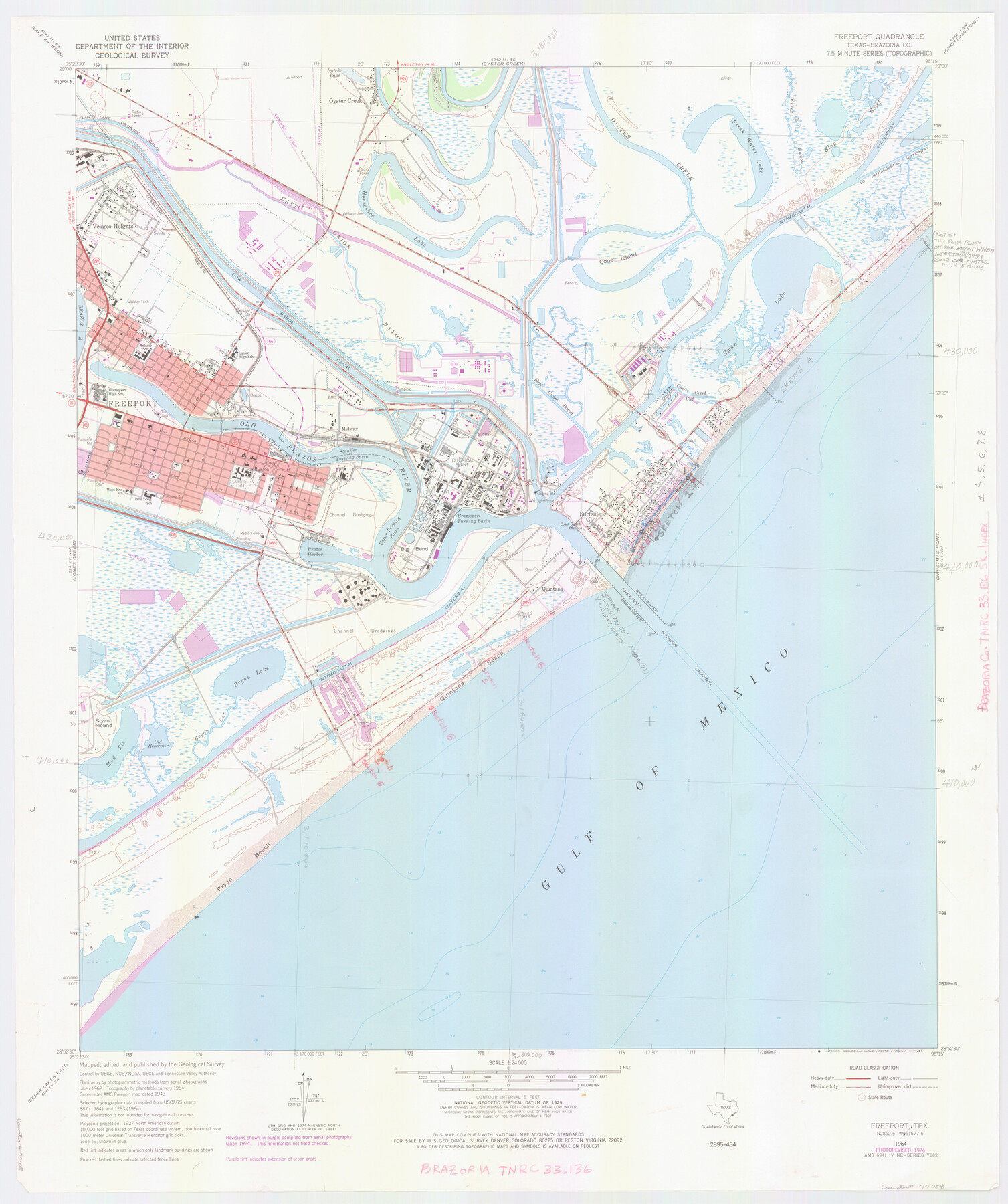
Brazoria County NRC Article 33.136 Location Key Sheet
Christmas Point Quadrangle
-
Map/Doc
77008
-
Collection
General Map Collection
-
Object Dates
1964 (Creation Date)
-
People and Organizations
U. S. Geological Survey (Publisher)
U. S. Geological Survey (Printer)
-
Counties
Brazoria
-
Subjects
Surveying CBS
-
Height x Width
27.0 x 22.0 inches
68.6 x 55.9 cm
Part of: General Map Collection
Chart of the Harbour of San [Luis]
![72762, Chart of the Harbour of San [Luis], General Map Collection](https://historictexasmaps.com/wmedia_w700/maps/72762.tif.jpg)
Print $20.00
- Digital $50.00
Chart of the Harbour of San [Luis]
1846
Size 27.2 x 18.2 inches
Map/Doc 72762
Edwards County Working Sketch 132

Print $20.00
- Digital $50.00
Edwards County Working Sketch 132
1985
Size 37.1 x 37.1 inches
Map/Doc 69008

Kimble County Working Sketch 74

Print $20.00
- Digital $50.00
Kimble County Working Sketch 74
1966
Size 43.1 x 34.2 inches
Map/Doc 70142
Galveston County NRC Article 33.136 Sketch 76

Print $26.00
- Digital $50.00
Galveston County NRC Article 33.136 Sketch 76
2014
Size 24.5 x 36.5 inches
Map/Doc 95125
Kleberg County Rolled Sketch 8

Print $20.00
- Digital $50.00
Kleberg County Rolled Sketch 8
1947
Size 33.0 x 42.0 inches
Map/Doc 9360
Flight Mission No. BRE-1P, Frame 4, Nueces County

Print $20.00
- Digital $50.00
Flight Mission No. BRE-1P, Frame 4, Nueces County
1956
Size 18.3 x 22.2 inches
Map/Doc 86612
Soil Map, Texas, Titus County Sheet

Print $20.00
- Digital $50.00
Soil Map, Texas, Titus County Sheet
1909
Size 30.5 x 22.4 inches
Map/Doc 3080
Duval County Sketch File 83

Print $20.00
- Digital $50.00
Duval County Sketch File 83
1933
Size 13.7 x 8.8 inches
Map/Doc 21521

Floyd County Boundary File 2a

Print $40.00
- Digital $50.00
Floyd County Boundary File 2a
Size 19.8 x 39.2 inches
Map/Doc 53488
Henderson County Sketch File 18

Print $20.00
- Digital $50.00
Henderson County Sketch File 18
1936
Size 16.7 x 18.3 inches
Map/Doc 11756
You may also like
Crockett County Rolled Sketch 74

Print $20.00
- Digital $50.00
Crockett County Rolled Sketch 74
1949
Size 19.4 x 24.9 inches
Map/Doc 5615
[Surveys along San Cristoval Creek]
![300, [Surveys along San Cristoval Creek], General Map Collection](https://historictexasmaps.com/wmedia_w700/maps/300.tif.jpg)
Print $2.00
- Digital $50.00
[Surveys along San Cristoval Creek]
1842
Size 9.0 x 9.3 inches
Map/Doc 300
Meadowbrook Villa a Subdivision in Section 77, Blk A

Print $20.00
- Digital $50.00
Meadowbrook Villa a Subdivision in Section 77, Blk A
Size 14.4 x 13.1 inches
Map/Doc 92768
Current Miscellaneous File 28

Print $22.00
- Digital $50.00
Current Miscellaneous File 28
1952
Size 10.7 x 16.3 inches
Map/Doc 73911
Polk County Working Sketch 30

Print $20.00
- Digital $50.00
Polk County Working Sketch 30
1960
Size 18.2 x 24.4 inches
Map/Doc 71646
Map of Galveston East Bay and Bolivar Peninsular

Print $40.00
- Digital $50.00
Map of Galveston East Bay and Bolivar Peninsular
1851
Size 30.9 x 75.8 inches
Map/Doc 69919
Moore County Rolled Sketch 13
Print $20.00
- Digital $50.00
Moore County Rolled Sketch 13
1920
Size 25.8 x 33.3 inches
Map/Doc 6829
[Subdivision of Nueces Bay and list of Court Decrees]
![2086, [Subdivision of Nueces Bay and list of Court Decrees], General Map Collection](https://historictexasmaps.com/wmedia_w700/maps/2086-1.tif.jpg)
Print $40.00
- Digital $50.00
[Subdivision of Nueces Bay and list of Court Decrees]
1940
Size 34.2 x 48.8 inches
Map/Doc 2086
Hamilton County Working Sketch 6

Print $20.00
- Digital $50.00
Hamilton County Working Sketch 6
1942
Size 21.7 x 20.1 inches
Map/Doc 63344

Voyages Autour du Monde, et vers les deux poles par terre et par mer - Tome Premier

Voyages Autour du Monde, et vers les deux poles par terre et par mer - Tome Premier
1782
Map/Doc 97085
Reconnaissance of the Coast of Texas between Matagorda and Corpus Christi Bays

Print $20.00
- Digital $50.00
Reconnaissance of the Coast of Texas between Matagorda and Corpus Christi Bays
1858
Size 25.2 x 21.4 inches
Map/Doc 75987