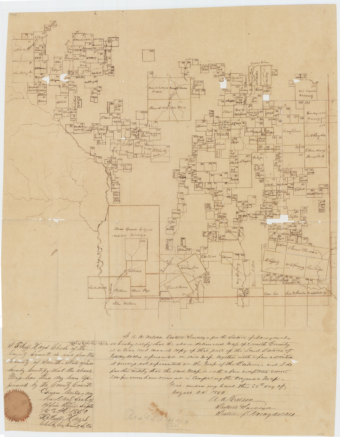
Smith County Sketch File 18
[Tracing of Smith County map]
-
Map/Doc
76752
-
Collection
General Map Collection
-
Object Dates
8/30/1850 (Creation Date)
12/4/1984 (File Date)
-
People and Organizations
A.A. Nelson (Surveyor/Engineer)
-
Counties
Smith
-
Subjects
County Surveying Sketch File
-
Height x Width
24.8 x 19.3 inches
63.0 x 49.0 cm
-
Medium
paper, manuscript
-
Features
Village Creek
Rock Creek
Sabine River
Little Saline Creek
Black Fork [of Prairie Fork] Creek
Prairie Fork Creek
Neches River
Saline
Part of: General Map Collection
Calhoun County Working Sketch 11

Print $20.00
- Digital $50.00
Calhoun County Working Sketch 11
1952
Size 43.1 x 34.9 inches
Map/Doc 67827
Kerr County Rolled Sketch 19

Print $20.00
- Digital $50.00
Kerr County Rolled Sketch 19
1954
Size 43.4 x 28.4 inches
Map/Doc 6501
Knox County Sketch File 13

Print $10.00
- Digital $50.00
Knox County Sketch File 13
1892
Size 10.0 x 8.0 inches
Map/Doc 29230
Reagan County Working Sketch 19

Print $20.00
- Digital $50.00
Reagan County Working Sketch 19
1954
Size 24.3 x 42.9 inches
Map/Doc 71861
Packery Channel

Print $20.00
- Digital $50.00
Packery Channel
1930
Size 26.6 x 37.1 inches
Map/Doc 2990
Garza County Working Sketch 13

Print $20.00
- Digital $50.00
Garza County Working Sketch 13
1956
Size 19.0 x 12.7 inches
Map/Doc 63160
Hutchinson County Working Sketch 33

Print $20.00
- Digital $50.00
Hutchinson County Working Sketch 33
1978
Size 27.5 x 23.5 inches
Map/Doc 66393

Tyler County Working Sketch 14

Print $20.00
- Digital $50.00
Tyler County Working Sketch 14
1959
Size 24.8 x 30.9 inches
Map/Doc 69484
Ward County Working Sketch 2

Print $20.00
- Digital $50.00
Ward County Working Sketch 2
1937
Size 22.9 x 28.7 inches
Map/Doc 72308
Haskell County Working Sketch 7

Print $40.00
- Digital $50.00
Haskell County Working Sketch 7
1956
Size 52.1 x 39.0 inches
Map/Doc 66065

You may also like
Blanco County Boundary File 53

Print $50.00
- Digital $50.00
Blanco County Boundary File 53
Size 9.2 x 7.7 inches
Map/Doc 50580
Flight Mission No. CRC-6R, Frame 38, Chambers County

Print $20.00
- Digital $50.00
Flight Mission No. CRC-6R, Frame 38, Chambers County
1956
Size 18.7 x 22.4 inches
Map/Doc 84971
Somervell County Rolled Sketch A

Print $20.00
- Digital $50.00
Somervell County Rolled Sketch A
Size 14.8 x 15.2 inches
Map/Doc 75999
Schleicher County Sketch File 20

Print $20.00
- Digital $50.00
Schleicher County Sketch File 20
1936
Size 16.8 x 17.4 inches
Map/Doc 12301
Real County Working Sketch 39

Print $20.00
- Digital $50.00
Real County Working Sketch 39
1951
Size 33.5 x 36.6 inches
Map/Doc 71931
La Salle County Sketch File 25

Print $4.00
- Digital $50.00
La Salle County Sketch File 25
Size 7.5 x 14.2 inches
Map/Doc 29549
Maps of Gulf Intracoastal Waterway, Texas - Sabine River to the Rio Grande and connecting waterways including ship channels

Print $20.00
- Digital $50.00
Maps of Gulf Intracoastal Waterway, Texas - Sabine River to the Rio Grande and connecting waterways including ship channels
1966
Size 14.5 x 22.2 inches
Map/Doc 61920
Upshur County Sketch File 1

Print $9.00
- Digital $50.00
Upshur County Sketch File 1
1854
Size 5.5 x 4.5 inches
Map/Doc 38728
Map of Smith County

Print $20.00
- Digital $50.00
Map of Smith County
1872
Size 20.0 x 20.6 inches
Map/Doc 4625
Map of Europe engraved to illustrate Mitchell's school and family geography

Print $20.00
- Digital $50.00
Map of Europe engraved to illustrate Mitchell's school and family geography
1839
Size 9.5 x 11.8 inches
Map/Doc 93502
[Lee County School Land and vicinity]
![90886, [Lee County School Land and vicinity], Twichell Survey Records](https://historictexasmaps.com/wmedia_w700/maps/90886-1.tif.jpg)
Print $2.00
- Digital $50.00
[Lee County School Land and vicinity]
Size 9.0 x 14.8 inches
Map/Doc 90886
Wichita County Sketch File 2

Print $8.00
- Digital $50.00
Wichita County Sketch File 2
Size 9.0 x 10.8 inches
Map/Doc 40030