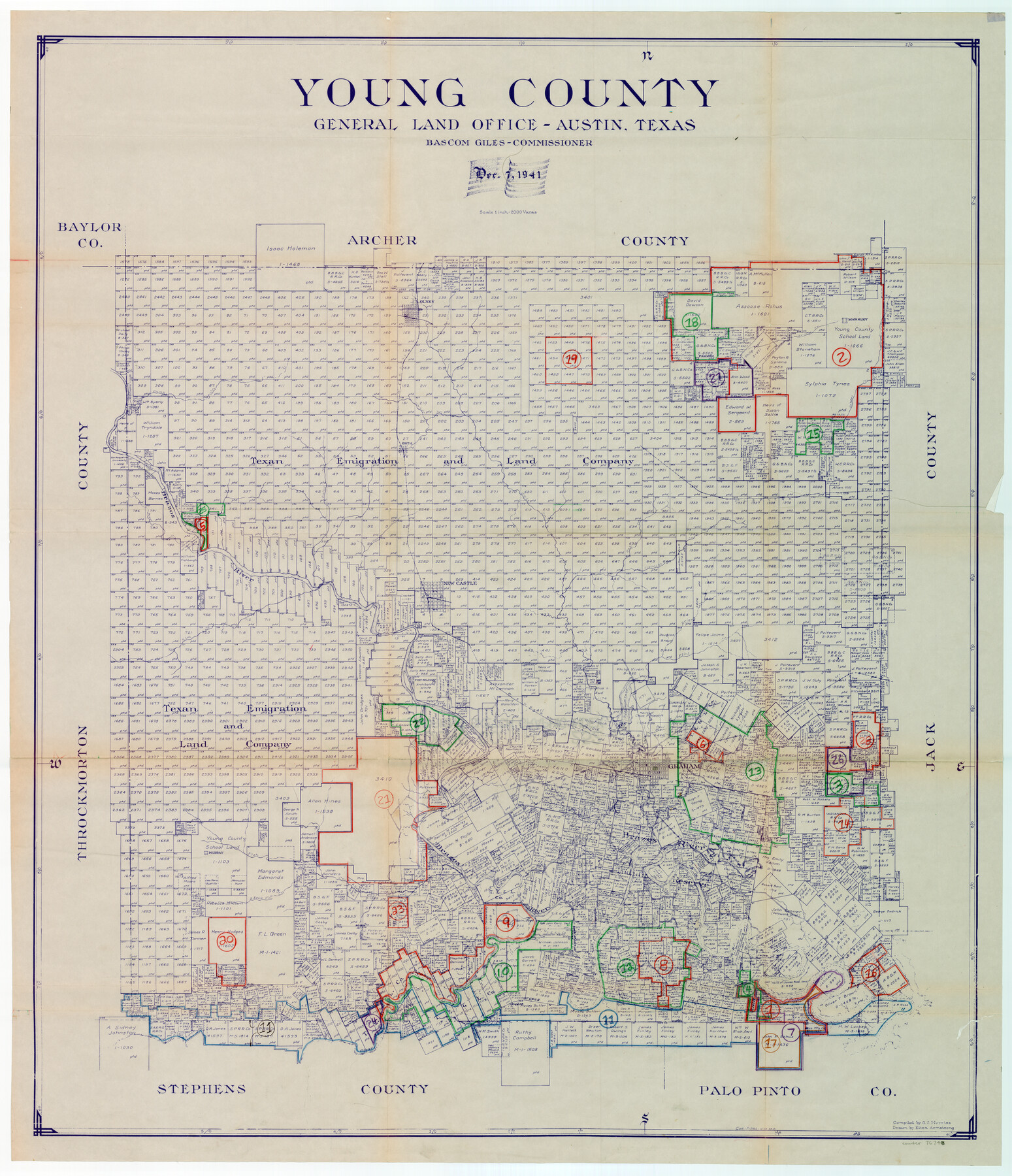
Young County Working Sketch Graphic Index
-
Map/Doc
76748
-
Collection
General Map Collection
-
Object Dates
12/7/1941 (Creation Date)
-
People and Organizations
G.C. Morriss (Compiler)
Eltea Armstrong (Draftsman)
-
Counties
Young
-
Subjects
County Surveying Working Sketch
-
Height x Width
44.1 x 38.4 inches
112.0 x 97.5 cm
-
Scale
1" = 2000 varas
Part of: General Map Collection
Brewster County Rolled Sketch 124

Print $20.00
- Digital $50.00
Brewster County Rolled Sketch 124
1975
Size 15.8 x 13.2 inches
Map/Doc 5299
Sutton County Rolled Sketch 48

Print $20.00
- Digital $50.00
Sutton County Rolled Sketch 48
1946
Size 35.9 x 22.9 inches
Map/Doc 7889
Trinity River, Levee Improvement Districts Widths of Floodways

Print $6.00
- Digital $50.00
Trinity River, Levee Improvement Districts Widths of Floodways
1920
Size 33.3 x 21.7 inches
Map/Doc 65251
Baylor County Aerial Photograph Index Sheet 2

Print $20.00
- Digital $50.00
Baylor County Aerial Photograph Index Sheet 2
1950
Size 22.2 x 15.4 inches
Map/Doc 83664
Travis County Working Sketch 28

Print $20.00
- Digital $50.00
Travis County Working Sketch 28
1955
Size 31.5 x 30.7 inches
Map/Doc 69412
Denton County Boundary File 2

Print $22.00
- Digital $50.00
Denton County Boundary File 2
Size 14.1 x 8.5 inches
Map/Doc 52413
Roseborough Lake Sheet, Bowie County, Red River

Print $20.00
- Digital $50.00
Roseborough Lake Sheet, Bowie County, Red River
1934
Size 39.5 x 23.0 inches
Map/Doc 75273
Kimble County Rolled Sketch 30

Print $20.00
- Digital $50.00
Kimble County Rolled Sketch 30
Size 26.0 x 20.4 inches
Map/Doc 6520
Duval County Sketch File 20 1/2

Print $4.00
- Digital $50.00
Duval County Sketch File 20 1/2
1880
Size 10.3 x 8.4 inches
Map/Doc 21324
Gaines County

Print $40.00
- Digital $50.00
Gaines County
1956
Size 45.1 x 56.6 inches
Map/Doc 95504
Kleberg County Rolled Sketch 9

Print $20.00
- Digital $50.00
Kleberg County Rolled Sketch 9
1954
Size 36.9 x 21.3 inches
Map/Doc 6551
Outer Continental Shelf Leasing Maps (Louisiana Offshore Operations)

Print $20.00
- Digital $50.00
Outer Continental Shelf Leasing Maps (Louisiana Offshore Operations)
1954
Size 18.2 x 16.0 inches
Map/Doc 76105
You may also like
Map of Escarpment Section through Webb County, Texas (South half of Webb County)

Print $40.00
- Digital $50.00
Map of Escarpment Section through Webb County, Texas (South half of Webb County)
1925
Size 43.3 x 76.2 inches
Map/Doc 93163
Panola County Working Sketch 1

Print $20.00
- Digital $50.00
Panola County Working Sketch 1
1917
Map/Doc 71410
Walker County Working Sketch 16

Print $20.00
- Digital $50.00
Walker County Working Sketch 16
1983
Size 36.5 x 42.4 inches
Map/Doc 72296
The Mexican Municipality of Brazoria. March 6, 1834

Print $20.00
The Mexican Municipality of Brazoria. March 6, 1834
2020
Size 16.0 x 21.7 inches
Map/Doc 96016
Flight Mission No. BRA-6M, Frame 96, Jefferson County

Print $20.00
- Digital $50.00
Flight Mission No. BRA-6M, Frame 96, Jefferson County
1953
Size 18.5 x 22.3 inches
Map/Doc 85439
Sketch H, Dickens County, Texas

Print $20.00
- Digital $50.00
Sketch H, Dickens County, Texas
1902
Size 16.0 x 14.3 inches
Map/Doc 4365
Crockett County Rolled Sketch 52

Print $20.00
- Digital $50.00
Crockett County Rolled Sketch 52
Size 36.7 x 44.7 inches
Map/Doc 8715
Refugio County Boundary File 74

Print $172.00
- Digital $50.00
Refugio County Boundary File 74
Size 9.3 x 4.4 inches
Map/Doc 58272
Stonewall County Sketch File AA1

Print $26.00
- Digital $50.00
Stonewall County Sketch File AA1
1916
Size 14.3 x 8.6 inches
Map/Doc 37288
Hardin County Sketch File 44

Print $6.00
- Digital $50.00
Hardin County Sketch File 44
Size 6.7 x 7.4 inches
Map/Doc 25192
[Aerial photograph from Carancahua Bend of Caney Creek to Cedar Lake]
![78640, [Aerial photograph from Carancahua Bend of Caney Creek to Cedar Lake], General Map Collection](https://historictexasmaps.com/wmedia_w700/maps/78640.tif.jpg)
Print $20.00
- Digital $50.00
[Aerial photograph from Carancahua Bend of Caney Creek to Cedar Lake]
1991
Size 24.4 x 30.3 inches
Map/Doc 78640
Andrews County Working Sketch 12

Print $20.00
- Digital $50.00
Andrews County Working Sketch 12
1956
Size 35.5 x 25.3 inches
Map/Doc 67058