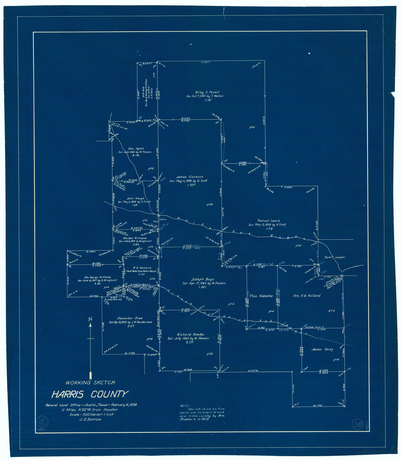
Harris County Working Sketch 35
-
Map/Doc
65927
-
Collection
General Map Collection
-
Object Dates
2/4/1938 (Creation Date)
-
People and Organizations
J.O. Barrow (Draftsman)
-
Counties
Harris
-
Subjects
Surveying Working Sketch
-
Height x Width
28.8 x 25.2 inches
73.2 x 64.0 cm
-
Scale
1" = 500 varas
Part of: General Map Collection
Wood County Sketch File 4

Print $4.00
- Digital $50.00
Wood County Sketch File 4
1855
Size 10.2 x 8.1 inches
Map/Doc 40635

Fractional Township No. 8 South Range No. 12 East of the Indian Meridian, Indian Territory

Print $20.00
- Digital $50.00
Fractional Township No. 8 South Range No. 12 East of the Indian Meridian, Indian Territory
1896
Size 19.2 x 24.4 inches
Map/Doc 75223

Williamson County Working Sketch Graphic Index

Print $40.00
- Digital $50.00
Williamson County Working Sketch Graphic Index
1946
Size 38.4 x 55.7 inches
Map/Doc 76742
[Galveston, Harrisburg & San Antonio Railroad from Cuero to Stockdale]
![64193, [Galveston, Harrisburg & San Antonio Railroad from Cuero to Stockdale], General Map Collection](https://historictexasmaps.com/wmedia_w700/maps/64193.tif.jpg)
Print $20.00
- Digital $50.00
[Galveston, Harrisburg & San Antonio Railroad from Cuero to Stockdale]
1907
Size 13.7 x 34.0 inches
Map/Doc 64193
Potter County Sketch File 22

Print $30.00
- Digital $50.00
Potter County Sketch File 22
1962
Size 14.2 x 8.6 inches
Map/Doc 34415
Outer Continental Shelf Leasing Maps (Louisiana Offshore Operations)

Print $20.00
- Digital $50.00
Outer Continental Shelf Leasing Maps (Louisiana Offshore Operations)
1955
Size 12.4 x 12.7 inches
Map/Doc 76086
Sutton County Sketch File 54

Print $6.00
- Digital $50.00
Sutton County Sketch File 54
1948
Size 10.8 x 11.5 inches
Map/Doc 37534
Galveston County NRC Article 33.136 Sketch 100

Print $46.00
Galveston County NRC Article 33.136 Sketch 100
2024
Map/Doc 97423
San Jacinto County Rolled Sketch 14

Print $20.00
- Digital $50.00
San Jacinto County Rolled Sketch 14
1998
Size 28.1 x 40.0 inches
Map/Doc 7564
Baylor County Working Sketch 12

Print $20.00
- Digital $50.00
Baylor County Working Sketch 12
1960
Size 27.3 x 21.6 inches
Map/Doc 67297
You may also like
Texas Panhandle East Boundary Line

Print $20.00
- Digital $50.00
Texas Panhandle East Boundary Line
1898
Size 11.6 x 35.5 inches
Map/Doc 1741
[Sections Q, L Tech Memorial Park]
![92303, [Sections Q, L Tech Memorial Park], Twichell Survey Records](https://historictexasmaps.com/wmedia_w700/maps/92303-1.tif.jpg)
Print $20.00
- Digital $50.00
[Sections Q, L Tech Memorial Park]
1956
Size 13.0 x 17.8 inches
Map/Doc 92303
Haskell County Sketch File 15a

Print $4.00
- Digital $50.00
Haskell County Sketch File 15a
Size 9.8 x 8.6 inches
Map/Doc 26161
Greenville, Tex., County Seat of Hunt County

Print $20.00
Greenville, Tex., County Seat of Hunt County
1886
Size 17.3 x 24.9 inches
Map/Doc 89089
Archer County Boundary File 1

Print $26.00
- Digital $50.00
Archer County Boundary File 1
Size 14.2 x 8.8 inches
Map/Doc 50082
Yoakum County Sketch File 16

Print $20.00
- Digital $50.00
Yoakum County Sketch File 16
1939
Size 15.0 x 19.4 inches
Map/Doc 12709
[Map of Texas]
![96624, [Map of Texas], Cobb Digital Map Collection](https://historictexasmaps.com/wmedia_w700/maps/96624.tif.jpg)
Print $20.00
- Digital $50.00
[Map of Texas]
1869
Size 9.9 x 8.8 inches
Map/Doc 96624
Bexar County Boundary File 2a

Print $12.00
- Digital $50.00
Bexar County Boundary File 2a
Size 10.0 x 8.1 inches
Map/Doc 50530
Flight Mission No. DAG-28K, Frame 31, Matagorda County

Print $20.00
- Digital $50.00
Flight Mission No. DAG-28K, Frame 31, Matagorda County
1953
Size 16.1 x 16.2 inches
Map/Doc 86599
Harris County Rolled Sketch WHW

Print $20.00
- Digital $50.00
Harris County Rolled Sketch WHW
1930
Size 20.7 x 41.6 inches
Map/Doc 6466
Stonewall County Working Sketch 21

Print $20.00
- Digital $50.00
Stonewall County Working Sketch 21
1961
Size 30.4 x 26.8 inches
Map/Doc 62328
Flight Mission No. CUG-2P, Frame 66, Kleberg County

Print $20.00
- Digital $50.00
Flight Mission No. CUG-2P, Frame 66, Kleberg County
1956
Size 18.5 x 22.2 inches
Map/Doc 86203