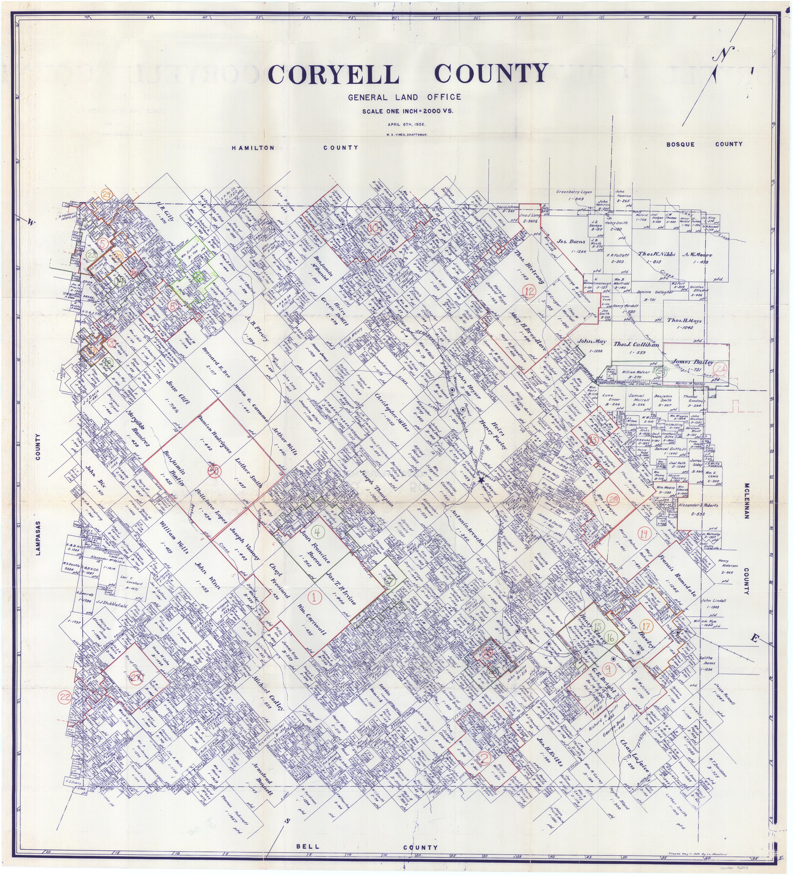
Coryell County Working Sketch Graphic Index
-
Map/Doc
76505
-
Collection
General Map Collection
-
Object Dates
4/6/1936 (Creation Date)
-
People and Organizations
W.S. Vines (Draftsman)
-
Counties
Coryell
-
Subjects
County Surveying Working Sketch
-
Height x Width
44.8 x 40.5 inches
113.8 x 102.9 cm
-
Scale
1" = 2000 varas
Part of: General Map Collection
Bell County Sketch File 16

Print $4.00
- Digital $50.00
Bell County Sketch File 16
1862
Size 12.0 x 8.3 inches
Map/Doc 14396
Flight Mission No. DQN-1K, Frame 157, Calhoun County

Print $20.00
- Digital $50.00
Flight Mission No. DQN-1K, Frame 157, Calhoun County
1953
Size 18.4 x 22.2 inches
Map/Doc 84216
Fayette County Working Sketch 2

Print $20.00
- Digital $50.00
Fayette County Working Sketch 2
1979
Size 40.6 x 37.8 inches
Map/Doc 69166
Calhoun County Working Sketch 13

Print $20.00
- Digital $50.00
Calhoun County Working Sketch 13
1962
Size 28.5 x 31.9 inches
Map/Doc 67829
Culberson County Sketch File 7

Print $8.00
- Digital $50.00
Culberson County Sketch File 7
1888
Size 14.5 x 8.8 inches
Map/Doc 20138
Schleicher County Working Sketch 17

Print $20.00
- Digital $50.00
Schleicher County Working Sketch 17
1946
Size 21.8 x 23.1 inches
Map/Doc 63819
Aransas County Rolled Sketch 4

Print $20.00
- Digital $50.00
Aransas County Rolled Sketch 4
1952
Size 28.9 x 26.4 inches
Map/Doc 77189
Nacogdoches County Sketch File 4

Print $4.00
- Digital $50.00
Nacogdoches County Sketch File 4
1858
Size 10.0 x 7.8 inches
Map/Doc 32241
Tom Green County Boundary File 5

Print $44.00
- Digital $50.00
Tom Green County Boundary File 5
Size 14.4 x 8.8 inches
Map/Doc 59363
Cottle County Rolled Sketch D

Print $20.00
- Digital $50.00
Cottle County Rolled Sketch D
1898
Size 29.0 x 20.4 inches
Map/Doc 5572
Dimmit County Working Sketch 11

Print $20.00
- Digital $50.00
Dimmit County Working Sketch 11
1935
Size 28.7 x 31.7 inches
Map/Doc 68672
Map accompanying report of scout made by 2nd Lt. F. de I. Carrington. 1st Infantry

Print $20.00
- Digital $50.00
Map accompanying report of scout made by 2nd Lt. F. de I. Carrington. 1st Infantry
1881
Size 22.2 x 18.0 inches
Map/Doc 65407
You may also like
Upton County Rolled Sketch 21

Print $20.00
- Digital $50.00
Upton County Rolled Sketch 21
1939
Size 21.5 x 37.9 inches
Map/Doc 8072
Freestone County Working Sketch 7

Print $20.00
- Digital $50.00
Freestone County Working Sketch 7
1951
Size 32.8 x 24.4 inches
Map/Doc 69249
Kinney County Sketch File 39

Print $20.00
- Digital $50.00
Kinney County Sketch File 39
1948
Size 18.8 x 21.0 inches
Map/Doc 11951
The Peters Colony. November 9, 1841

Print $20.00
The Peters Colony. November 9, 1841
2020
Size 21.7 x 21.7 inches
Map/Doc 96363
Pecos County Working Sketch 53

Print $20.00
- Digital $50.00
Pecos County Working Sketch 53
1948
Size 37.6 x 25.8 inches
Map/Doc 71525
Briscoe County Rolled Sketch 14

Print $40.00
- Digital $50.00
Briscoe County Rolled Sketch 14
1913
Size 36.0 x 48.9 inches
Map/Doc 8529
Jno. W. Pritchett Preliminary Official LO Map for Lubbock [County]
![89901, Jno. W. Pritchett Preliminary Official LO Map for Lubbock [County], Twichell Survey Records](https://historictexasmaps.com/wmedia_w700/maps/89901-1.tif.jpg)
Print $20.00
- Digital $50.00
Jno. W. Pritchett Preliminary Official LO Map for Lubbock [County]
Size 41.1 x 40.3 inches
Map/Doc 89901
Chambers County Sketch File A

Print $20.00
- Digital $50.00
Chambers County Sketch File A
1900
Size 21.3 x 21.5 inches
Map/Doc 11071
Upton County Rolled Sketch 7

Print $62.00
- Digital $50.00
Upton County Rolled Sketch 7
1911
Size 10.5 x 15.0 inches
Map/Doc 49398
Map of Motley County

Print $20.00
- Digital $50.00
Map of Motley County
1902
Size 43.4 x 37.7 inches
Map/Doc 10799
Nueces County Sketch File 55

Print $16.00
- Digital $50.00
Nueces County Sketch File 55
1999
Size 11.3 x 8.8 inches
Map/Doc 32867
Lampasas County Boundary File 10

Print $11.00
- Digital $50.00
Lampasas County Boundary File 10
Size 12.8 x 7.9 inches
Map/Doc 56184