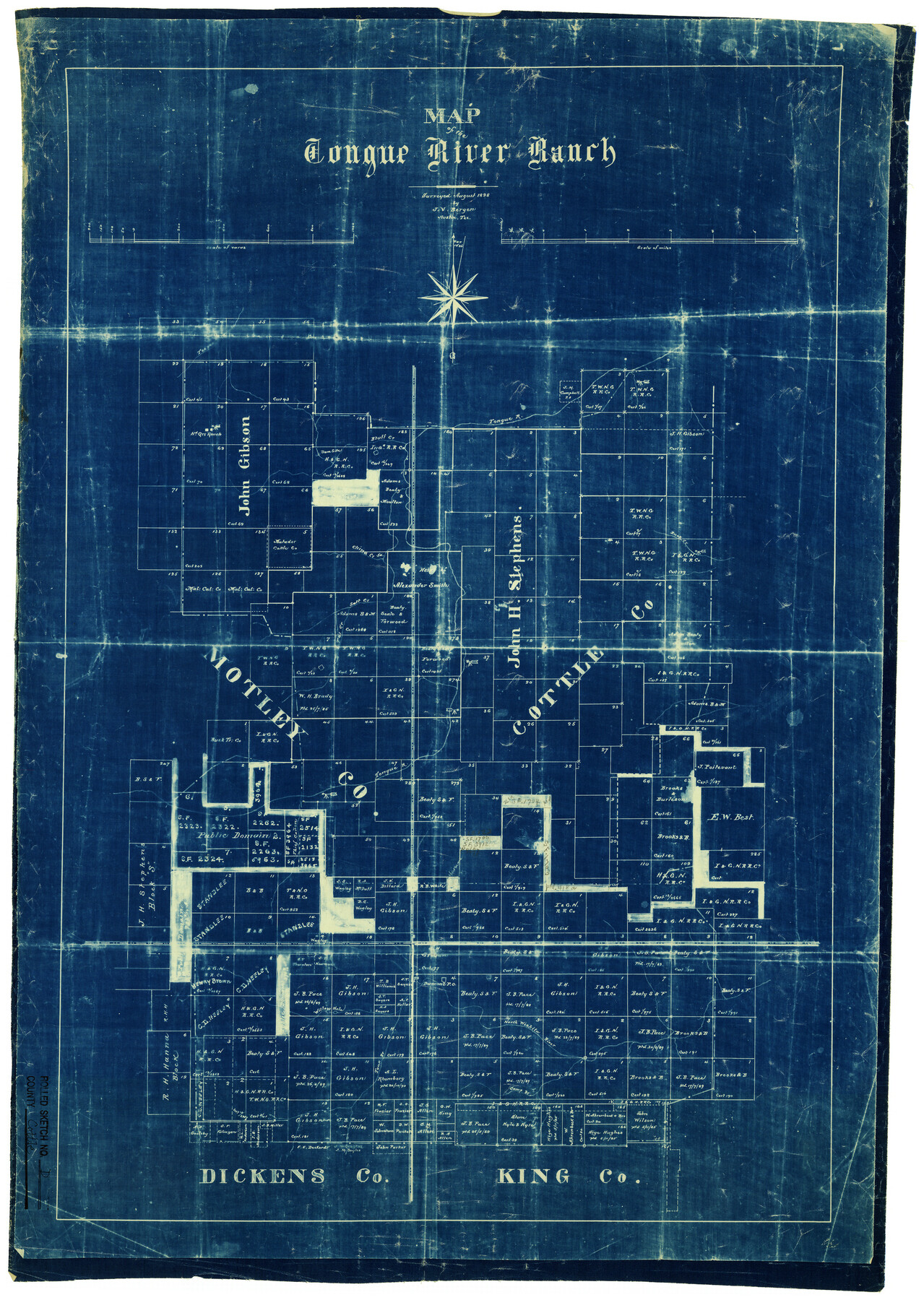
Cottle County Rolled Sketch D
Map of the Tongue River Ranch
-
Map/Doc
5572
-
Collection
General Map Collection
-
Object Dates
8/1898 (Creation Date)
7/13/1904 (File Date)
-
People and Organizations
J.V. Bergen (Surveyor/Engineer)
-
Counties
Cottle Motley Dickens King
-
Subjects
Surveying Rolled Sketch
-
Height x Width
29.0 x 20.4 inches
73.7 x 51.8 cm
-
Medium
blueprint/diazo
Part of: General Map Collection
Caldwell County Sketch File 3

Print $4.00
- Digital $50.00
Caldwell County Sketch File 3
1872
Size 12.7 x 8.1 inches
Map/Doc 35827
Jefferson County Sketch File 54

Print $226.00
- Digital $50.00
Jefferson County Sketch File 54
1961
Size 11.0 x 8.5 inches
Map/Doc 28359
Brooks County Rolled Sketch 22

Print $20.00
- Digital $50.00
Brooks County Rolled Sketch 22
1943
Size 15.1 x 32.2 inches
Map/Doc 5343
Uvalde County Sketch File 17

Print $20.00
- Digital $50.00
Uvalde County Sketch File 17
1882
Size 17.5 x 17.9 inches
Map/Doc 12531
Pecos County Sketch File 104

Print $36.00
- Digital $50.00
Pecos County Sketch File 104
1966
Size 11.3 x 8.7 inches
Map/Doc 34020
Flight Mission No. CRC-4R, Frame 175, Chambers County

Print $20.00
- Digital $50.00
Flight Mission No. CRC-4R, Frame 175, Chambers County
1956
Size 18.6 x 22.2 inches
Map/Doc 84926
Gillespie County Rolled Sketch 5

Print $20.00
- Digital $50.00
Gillespie County Rolled Sketch 5
1994
Size 25.7 x 20.6 inches
Map/Doc 6012
Mills County Boundary File 4

Print $40.00
- Digital $50.00
Mills County Boundary File 4
Size 52.1 x 13.3 inches
Map/Doc 57293
Angelina County Working Sketch 23

Print $20.00
- Digital $50.00
Angelina County Working Sketch 23
1953
Size 19.8 x 32.6 inches
Map/Doc 67105
Armstrong County Working Sketch 5

Print $40.00
- Digital $50.00
Armstrong County Working Sketch 5
1918
Size 48.4 x 41.9 inches
Map/Doc 67236
Harris County Sketch File 12

Print $40.00
- Digital $50.00
Harris County Sketch File 12
1896
Size 16.1 x 12.5 inches
Map/Doc 25353
Map of Leon County

Print $20.00
- Digital $50.00
Map of Leon County
1871
Size 23.6 x 21.2 inches
Map/Doc 3808
You may also like
Killian Subdivision of the Northeast Portion of Section 42, Block AK

Print $20.00
- Digital $50.00
Killian Subdivision of the Northeast Portion of Section 42, Block AK
Size 15.9 x 14.1 inches
Map/Doc 92267
Flight Mission No. BRA-9M, Frame 78, Jefferson County

Print $20.00
- Digital $50.00
Flight Mission No. BRA-9M, Frame 78, Jefferson County
1953
Size 18.5 x 22.5 inches
Map/Doc 85661
Flight Mission No. CRC-3R, Frame 32, Chambers County

Print $20.00
- Digital $50.00
Flight Mission No. CRC-3R, Frame 32, Chambers County
1956
Size 18.6 x 22.3 inches
Map/Doc 84805
Flight Mission No. DIX-10P, Frame 151, Aransas County

Print $20.00
- Digital $50.00
Flight Mission No. DIX-10P, Frame 151, Aransas County
1956
Size 18.7 x 22.3 inches
Map/Doc 83953
Pecos County Sketch File 106

Print $6.00
- Digital $50.00
Pecos County Sketch File 106
1967
Size 14.2 x 8.8 inches
Map/Doc 34030
Val Verde County Rolled Sketch 1

Print $40.00
- Digital $50.00
Val Verde County Rolled Sketch 1
1885
Size 69.8 x 39.1 inches
Map/Doc 10068
Wise County Sketch File 2

Print $8.00
- Digital $50.00
Wise County Sketch File 2
1856
Size 8.2 x 13.4 inches
Map/Doc 40523


Louisiana and Texas for the Winter Tourist

Louisiana and Texas for the Winter Tourist
1911
Map/Doc 96716
[H. & G. N. RR. Co. Block 1]
![90892, [H. & G. N. RR. Co. Block 1], Twichell Survey Records](https://historictexasmaps.com/wmedia_w700/maps/90892-1.tif.jpg)
Print $20.00
- Digital $50.00
[H. & G. N. RR. Co. Block 1]
1902
Size 14.9 x 15.8 inches
Map/Doc 90892
Terrell County Working Sketch 84d

Print $20.00
- Digital $50.00
Terrell County Working Sketch 84d
1992
Size 18.4 x 31.5 inches
Map/Doc 69608