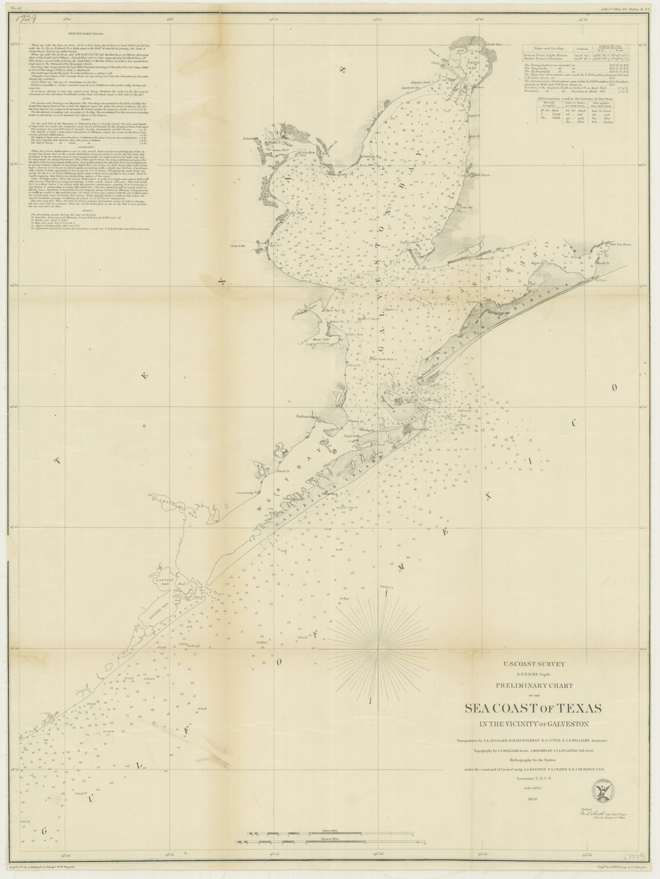
Preliminary Chart of the Sea Coast of Texas in the Vicinity of Galveston
-
Map/Doc
76256
-
Collection
Texas State Library and Archives
-
Object Dates
1856 (Creation Date)
-
People and Organizations
U.S. Coast Survey (Publisher)
J.M. Wampler (Surveyor/Engineer)
J.E. Hilgard (Surveyor/Engineer)
R.H. Fauntleroy (Surveyor/Engineer)
R.D. Cutts (Surveyor/Engineer)
J.S. Williams (Surveyor/Engineer)
-
Counties
Galveston
-
Subjects
Nautical Charts
-
Height x Width
26.3 x 19.7 inches
66.8 x 50.0 cm
-
Comments
Prints available courtesy of the Texas State Library and Archives.
More info can be found here: TSLAC Map 01729
Part of: Texas State Library and Archives
A.R. Roessler's Latest Map of the State of Texas Exhibiting Mineral and Agricultural Districts, Post Offices and Mailroutes, Railroads projected and finished, Timber, Prairie, Swamp Lands, etc. etc. etc.

Print $20.00
A.R. Roessler's Latest Map of the State of Texas Exhibiting Mineral and Agricultural Districts, Post Offices and Mailroutes, Railroads projected and finished, Timber, Prairie, Swamp Lands, etc. etc. etc.
1874
Size 39.7 x 46.8 inches
Map/Doc 76254
General Highway Map. Detail of Cities and Towns in Bexar County, Texas. City Map of San Antonio, Alamo Heights, Olmos Park, Terrell Hills, Castle Hills, Balcones Heights, and vicinity, Bexar County, Texas

Print $20.00
General Highway Map. Detail of Cities and Towns in Bexar County, Texas. City Map of San Antonio, Alamo Heights, Olmos Park, Terrell Hills, Castle Hills, Balcones Heights, and vicinity, Bexar County, Texas
1961
Size 25.0 x 18.1 inches
Map/Doc 79374
General Highway Map, Hidalgo County, Texas

Print $20.00
General Highway Map, Hidalgo County, Texas
1940
Size 18.4 x 25.0 inches
Map/Doc 79128
General Highway Map, Nolan County, Texas

Print $20.00
General Highway Map, Nolan County, Texas
1940
Size 18.4 x 24.7 inches
Map/Doc 79208
General Highway Map, Ellis County, Texas

Print $20.00
General Highway Map, Ellis County, Texas
1939
Size 18.4 x 24.9 inches
Map/Doc 79083
Mitchell's Travellers Guide Through the United States. A Map of the Roads, Distances, Steam Boat, and Canal Routes etc.

Print $20.00
Mitchell's Travellers Guide Through the United States. A Map of the Roads, Distances, Steam Boat, and Canal Routes etc.
1834
Size 18.2 x 22.6 inches
Map/Doc 79314

General Highway Map, Webb County, Texas

Print $20.00
General Highway Map, Webb County, Texas
1961
Size 18.2 x 24.8 inches
Map/Doc 79704
General Highway Map, Colorado County, Texas

Print $20.00
General Highway Map, Colorado County, Texas
1961
Size 25.1 x 18.3 inches
Map/Doc 79416
General Highway Map, Shelby County, Texas

Print $20.00
General Highway Map, Shelby County, Texas
1940
Size 18.3 x 24.8 inches
Map/Doc 79242
Plan of Mier. The Texian Camp and Attack on the City

Print $20.00
Plan of Mier. The Texian Camp and Attack on the City
1842
Size 8.7 x 11.4 inches
Map/Doc 76305
Special Map of the Great Southwest for Burke's Texas Almanac

Print $20.00
Special Map of the Great Southwest for Burke's Texas Almanac
1885
Size 42.1 x 28.5 inches
Map/Doc 76214
You may also like
Reagan County Working Sketch 25

Print $20.00
- Digital $50.00
Reagan County Working Sketch 25
1958
Size 45.8 x 42.8 inches
Map/Doc 71867
Nueces County NRC Article 33.136 Sketch 18

Print $74.00
- Digital $50.00
Nueces County NRC Article 33.136 Sketch 18
2014
Size 22.0 x 34.0 inches
Map/Doc 94714
Pecos County Rolled Sketch 166

Print $22.00
- Digital $50.00
Pecos County Rolled Sketch 166
Size 32.5 x 37.6 inches
Map/Doc 9747
Frio County Rolled Sketch 15

Print $20.00
- Digital $50.00
Frio County Rolled Sketch 15
1949
Size 26.1 x 39.0 inches
Map/Doc 5922
Wilbarger County Working Sketch 16

Print $20.00
- Digital $50.00
Wilbarger County Working Sketch 16
1955
Size 32.7 x 19.9 inches
Map/Doc 72554
South Part Crockett County

Print $40.00
- Digital $50.00
South Part Crockett County
1977
Size 39.1 x 51.2 inches
Map/Doc 95471
El Nuevo Mexico y Tierras Adyacentes Mapa Levantado para la demarcacion de los Limites de los Dominios Españoles y de los Estados Unidos

Print $20.00
El Nuevo Mexico y Tierras Adyacentes Mapa Levantado para la demarcacion de los Limites de los Dominios Españoles y de los Estados Unidos
1811
Size 27.1 x 36.4 inches
Map/Doc 97477
Moore County Rolled Sketch 16

Print $20.00
- Digital $50.00
Moore County Rolled Sketch 16
1981
Size 21.8 x 27.8 inches
Map/Doc 6833
Galveston County NRC Article 33.136 Sketch 23

Print $22.00
- Digital $50.00
Galveston County NRC Article 33.136 Sketch 23
2002
Size 11.4 x 16.4 inches
Map/Doc 81905
[Map showing T&P Lands in El Paso County]
![88933, [Map showing T&P Lands in El Paso County], Library of Congress](https://historictexasmaps.com/wmedia_w700/maps/88933.tif.jpg)
Print $20.00
[Map showing T&P Lands in El Paso County]
Size 17.2 x 22.1 inches
Map/Doc 88933
Burnet County Sketch File 21

Print $4.00
- Digital $50.00
Burnet County Sketch File 21
Size 8.4 x 6.6 inches
Map/Doc 16714
Gillespie County Sketch File 16

Print $20.00
- Digital $50.00
Gillespie County Sketch File 16
1951
Size 18.2 x 17.9 inches
Map/Doc 11557