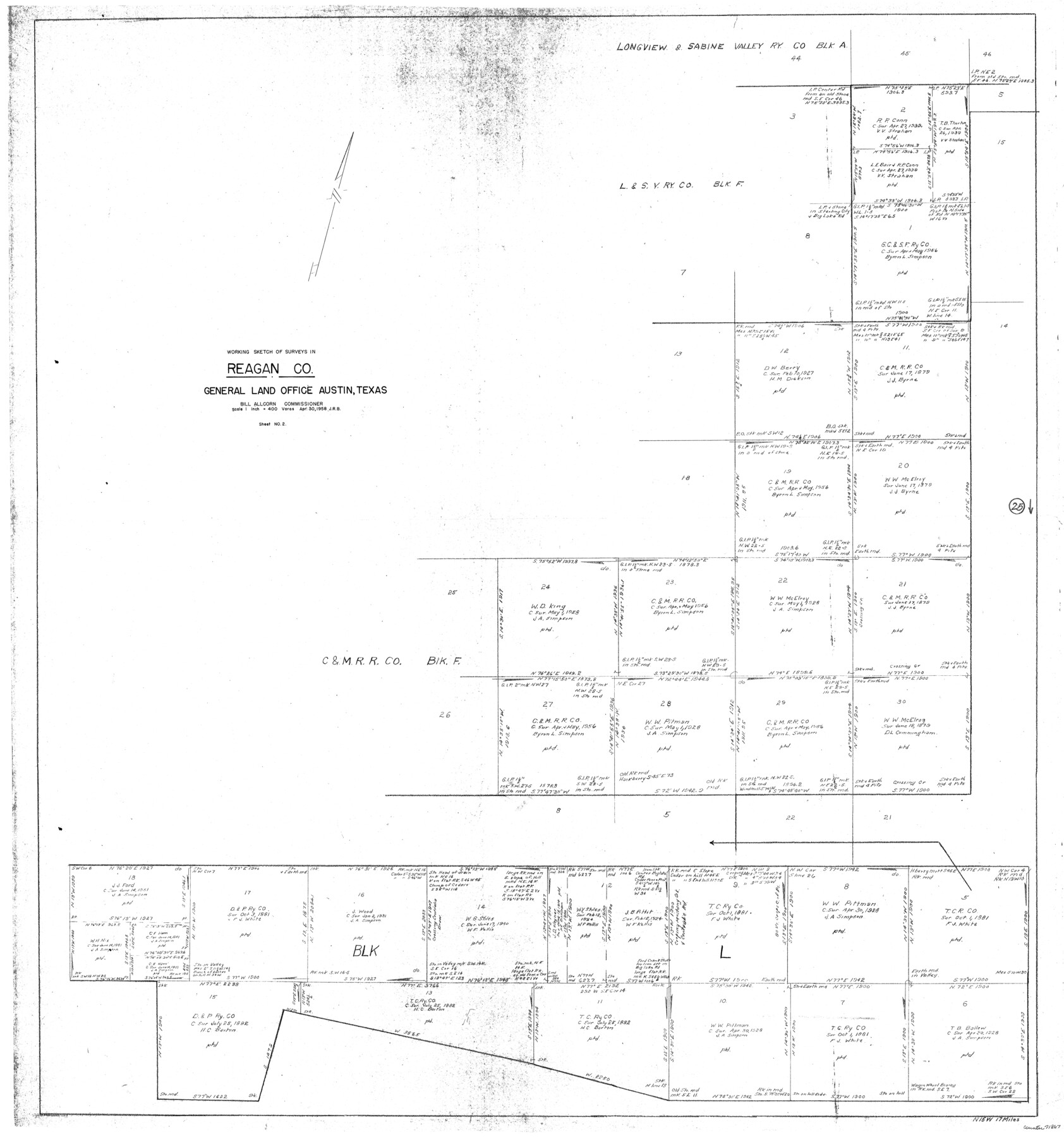
Reagan County Working Sketch 25
-
Map/Doc
71867
-
Collection
General Map Collection
-
Object Dates
4/30/1958 (Creation Date)
-
Counties
Reagan
-
Subjects
Surveying Working Sketch
-
Height x Width
45.8 x 42.8 inches
116.3 x 108.7 cm
-
Scale
1" = 400 varas
Part of: General Map Collection
Jack County Working Sketch 24

Print $20.00
- Digital $50.00
Jack County Working Sketch 24
2010
Size 24.1 x 29.7 inches
Map/Doc 90030
Orange County Working Sketch 53

Print $20.00
- Digital $50.00
Orange County Working Sketch 53
2007
Size 34.1 x 46.0 inches
Map/Doc 87371
Freestone County Working Sketch 12

Print $40.00
- Digital $50.00
Freestone County Working Sketch 12
1980
Size 54.5 x 38.6 inches
Map/Doc 69254
Ector County Rolled Sketch 9

Print $20.00
- Digital $50.00
Ector County Rolled Sketch 9
1940
Size 39.1 x 43.0 inches
Map/Doc 8837
Bandera County Boundary File 7

Print $14.00
- Digital $50.00
Bandera County Boundary File 7
Size 12.7 x 8.1 inches
Map/Doc 50306
Houston County Working Sketch 13

Print $20.00
- Digital $50.00
Houston County Working Sketch 13
1956
Size 39.3 x 39.6 inches
Map/Doc 66243
Coleman County Sketch File 20

Print $4.00
- Digital $50.00
Coleman County Sketch File 20
1871
Size 12.9 x 8.0 inches
Map/Doc 18694
Bell County Sketch File 26

Print $14.00
- Digital $50.00
Bell County Sketch File 26
1886
Size 14.2 x 8.8 inches
Map/Doc 14426
Dickens County Sketch File 5

Print $40.00
- Digital $50.00
Dickens County Sketch File 5
Size 24.3 x 18.1 inches
Map/Doc 75996
McCulloch County Rolled Sketch 1

Print $20.00
- Digital $50.00
McCulloch County Rolled Sketch 1
Size 44.4 x 36.9 inches
Map/Doc 9495

Fort Bend County Working Sketch 24

Print $20.00
- Digital $50.00
Fort Bend County Working Sketch 24
1981
Size 27.1 x 30.5 inches
Map/Doc 69230
You may also like
Wilson County Sketch File 8

Print $8.00
- Digital $50.00
Wilson County Sketch File 8
1879
Size 10.4 x 8.2 inches
Map/Doc 40413
General Highway Map, Bailey County, Texas

Print $20.00
General Highway Map, Bailey County, Texas
1961
Size 25.0 x 18.2 inches
Map/Doc 79359
[Blocks XO3 and I]
![91167, [Blocks XO3 and I], Twichell Survey Records](https://historictexasmaps.com/wmedia_w700/maps/91167-1.tif.jpg)
Print $2.00
- Digital $50.00
[Blocks XO3 and I]
Size 6.5 x 11.8 inches
Map/Doc 91167
Atascosa County Rolled Sketch 15

Print $20.00
- Digital $50.00
Atascosa County Rolled Sketch 15
1945
Size 45.2 x 42.7 inches
Map/Doc 8433
Cottle County Working Sketch 1

Print $20.00
- Digital $50.00
Cottle County Working Sketch 1
1895
Size 27.0 x 21.7 inches
Map/Doc 68311

A Geological Map of the United States and Canada

Print $20.00
A Geological Map of the United States and Canada
1853
Size 17.4 x 25.0 inches
Map/Doc 95189
Map of Refugio District

Print $20.00
- Digital $50.00
Map of Refugio District
1850
Size 22.6 x 25.1 inches
Map/Doc 1959
[H. P. Fleming, J. E. Fitzgerald, J. R. Scott and surrounding surveys]
![90954, [H. P. Fleming, J. E. Fitzgerald, J. R. Scott and surrounding surveys], Twichell Survey Records](https://historictexasmaps.com/wmedia_w700/maps/90954-1.tif.jpg)
Print $20.00
- Digital $50.00
[H. P. Fleming, J. E. Fitzgerald, J. R. Scott and surrounding surveys]
Size 19.7 x 12.9 inches
Map/Doc 90954
Map of Orange County

Print $20.00
- Digital $50.00
Map of Orange County
1880
Size 15.2 x 19.2 inches
Map/Doc 3930
Lavaca County Rolled Sketch 8

Print $40.00
- Digital $50.00
Lavaca County Rolled Sketch 8
1982
Size 36.5 x 65.6 inches
Map/Doc 10289
Nueces County Rolled Sketch 58

Print $50.00
Nueces County Rolled Sketch 58
1979
Size 28.2 x 40.1 inches
Map/Doc 6899