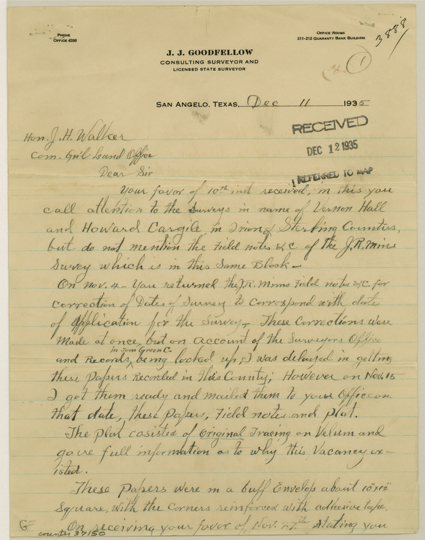
Sterling County Sketch File 15
[Letter of explanation regarding lands in the name of Vernon Hall and Howard Cargile]
-
Map/Doc
37150
-
Collection
General Map Collection
-
Object Dates
1935/12/11 (Creation Date)
1935/12/12 (File Date)
1935/12/11 (Correspondence Date)
-
People and Organizations
J.J. Goodfellow (Surveyor/Engineer)
-
Counties
Sterling Irion
-
Subjects
Surveying Sketch File
-
Height x Width
11.1 x 8.8 inches
28.2 x 22.4 cm
-
Medium
paper, manuscript
-
Features
Rock Creek
Part of: General Map Collection
Boundary Between the United States & Mexico Agreed upon by the Joint Commission under the Treaty of Guadalupe Hidalgo

Print $20.00
- Digital $50.00
Boundary Between the United States & Mexico Agreed upon by the Joint Commission under the Treaty of Guadalupe Hidalgo
1853
Size 18.3 x 26.5 inches
Map/Doc 72886
Map of the City of Corsicana (Navarro County) Texas

Print $40.00
- Digital $50.00
Map of the City of Corsicana (Navarro County) Texas
1963
Size 40.1 x 91.8 inches
Map/Doc 93674
Diefert Situs Orbis Hydrographorum ab eo quem Ptolomeus Posuit

Print $20.00
- Digital $50.00
Diefert Situs Orbis Hydrographorum ab eo quem Ptolomeus Posuit
1522
Size 13.9 x 19.1 inches
Map/Doc 96578
Kent County Sketch File 8

Print $20.00
- Digital $50.00
Kent County Sketch File 8
Size 19.0 x 40.8 inches
Map/Doc 10515
Map of Texas Compiled from surveys on record in the General Land Office of the Republic to the year 1839

Print $20.00
- Digital $50.00
Map of Texas Compiled from surveys on record in the General Land Office of the Republic to the year 1839
1891
Size 36.6 x 25.7 inches
Map/Doc 1891
[Surveys in the Travis District along the Colorado River]
![117, [Surveys in the Travis District along the Colorado River], General Map Collection](https://historictexasmaps.com/wmedia_w700/maps/117.tif.jpg)
Print $2.00
- Digital $50.00
[Surveys in the Travis District along the Colorado River]
1840
Size 8.9 x 6.3 inches
Map/Doc 117
Sabine County Working Sketch 12

Print $20.00
- Digital $50.00
Sabine County Working Sketch 12
1935
Size 39.2 x 45.9 inches
Map/Doc 63683
Cherokee County Sketch File 17

Print $6.00
- Digital $50.00
Cherokee County Sketch File 17
1862
Size 11.6 x 7.7 inches
Map/Doc 18156
Hamilton County Rolled Sketch 10

Print $20.00
- Digital $50.00
Hamilton County Rolled Sketch 10
1949
Size 22.2 x 27.5 inches
Map/Doc 6059
Brazoria County Sketch File 5

Print $4.00
- Digital $50.00
Brazoria County Sketch File 5
1862
Size 13.1 x 8.1 inches
Map/Doc 14929
Gregg County Boundary File 2

Print $8.00
- Digital $50.00
Gregg County Boundary File 2
Size 8.8 x 3.7 inches
Map/Doc 53984
Freestone County Rolled Sketch 12A

Print $40.00
- Digital $50.00
Freestone County Rolled Sketch 12A
1987
Size 35.2 x 48.6 inches
Map/Doc 8897
You may also like
Culberson County Rolled Sketch 46

Print $40.00
- Digital $50.00
Culberson County Rolled Sketch 46
1953
Size 53.1 x 43.1 inches
Map/Doc 8754
[Parts of Public School Land Blocks 39, 31, C-40, C-42, E. L. & R. R. Blocks H, I]
![91271, [Parts of Public School Land Blocks 39, 31, C-40, C-42, E. L. & R. R. Blocks H, I], Twichell Survey Records](https://historictexasmaps.com/wmedia_w700/maps/91271-1.tif.jpg)
Print $20.00
- Digital $50.00
[Parts of Public School Land Blocks 39, 31, C-40, C-42, E. L. & R. R. Blocks H, I]
Size 14.2 x 19.5 inches
Map/Doc 91271
Vicinity of San Luis Pass, Galveston Island, Texas

Print $40.00
- Digital $50.00
Vicinity of San Luis Pass, Galveston Island, Texas
1933
Size 37.1 x 57.8 inches
Map/Doc 69943
Goliad County Working Sketch 9

Print $20.00
- Digital $50.00
Goliad County Working Sketch 9
1938
Size 19.3 x 27.6 inches
Map/Doc 63199
Gaines County Sketch File 7

Print $6.00
- Digital $50.00
Gaines County Sketch File 7
1915
Size 14.3 x 8.7 inches
Map/Doc 23188
Burleson County Working Sketch 30

Print $20.00
- Digital $50.00
Burleson County Working Sketch 30
1981
Size 37.4 x 26.9 inches
Map/Doc 67749
[Leagues 615 ,616, and 242]
![91064, [Leagues 615 ,616, and 242], Twichell Survey Records](https://historictexasmaps.com/wmedia_w700/maps/91064-1.tif.jpg)
Print $20.00
- Digital $50.00
[Leagues 615 ,616, and 242]
Size 12.9 x 13.5 inches
Map/Doc 91064

General Highway Map, Crane County, Texas

Print $20.00
General Highway Map, Crane County, Texas
1940
Size 25.2 x 18.3 inches
Map/Doc 79061
Crockett County Sketch File 93

Print $8.00
- Digital $50.00
Crockett County Sketch File 93
1887
Size 12.7 x 8.2 inches
Map/Doc 19946
Shackelford County Rolled Sketch 5

Print $20.00
- Digital $50.00
Shackelford County Rolled Sketch 5
1984
Size 23.1 x 37.1 inches
Map/Doc 7773
Port of Galveston

Print $40.00
- Digital $50.00
Port of Galveston
1978
Size 20.0 x 68.9 inches
Map/Doc 83336