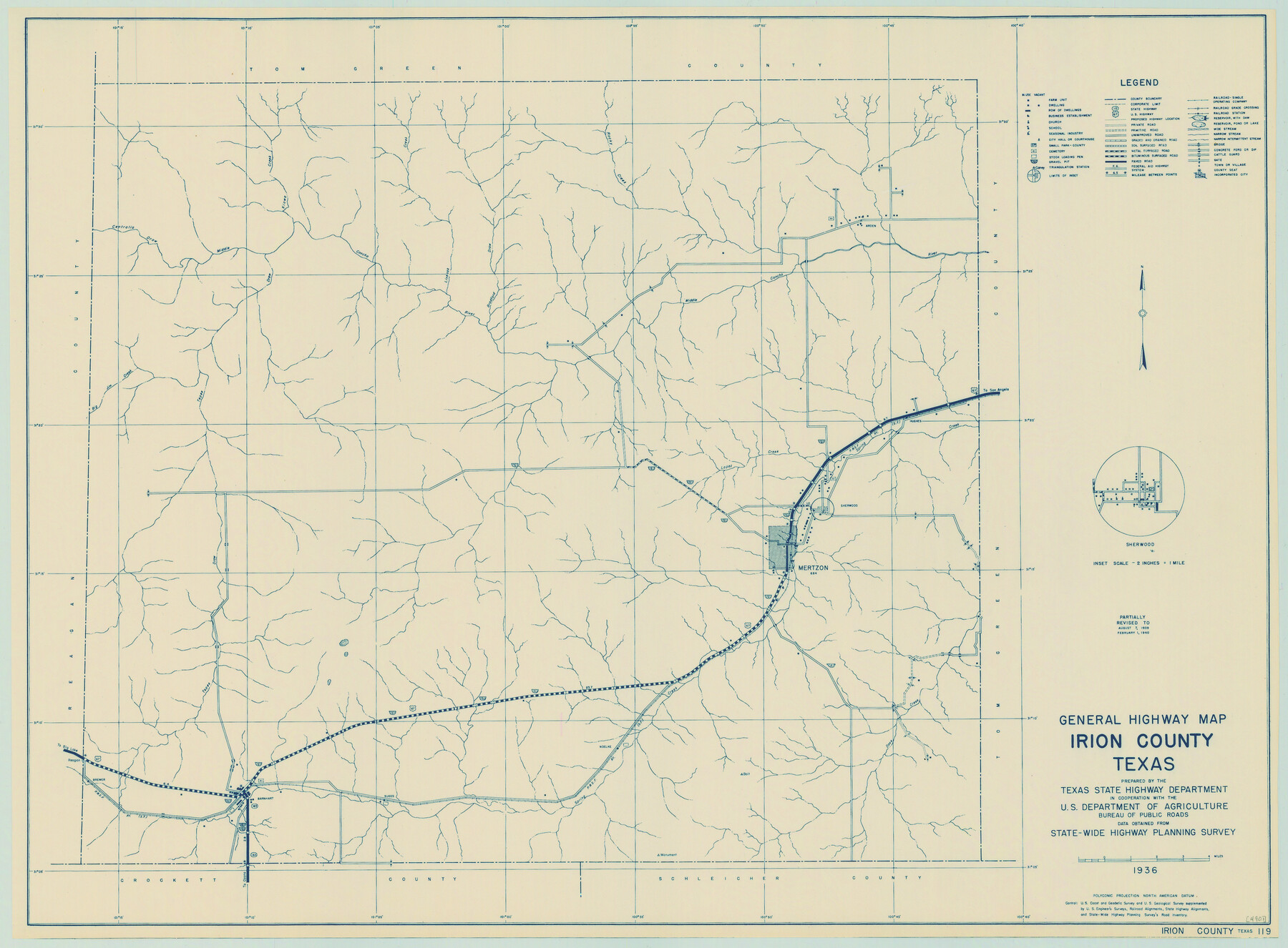
General Highway Map, Irion County, Texas
-
Map/Doc
79138
-
Collection
Texas State Library and Archives
-
Object Dates
1940 (Creation Date)
-
People and Organizations
Texas State Highway Department (Publisher)
-
Counties
Irion
-
Subjects
County
-
Height x Width
18.3 x 24.8 inches
46.5 x 63.0 cm
-
Comments
Prints available courtesy of the Texas State Library and Archives.
More info can be found here: TSLAC Map 04901
Part of: Texas State Library and Archives
Preliminary Chart of the Sea Coast of Texas in the Vicinity of Galveston

Print $20.00
Preliminary Chart of the Sea Coast of Texas in the Vicinity of Galveston
1856
Size 26.3 x 19.7 inches
Map/Doc 76256
Colton's New Map of the State of Texas Compiled from J. DeCordova's large Map

Print $20.00
Colton's New Map of the State of Texas Compiled from J. DeCordova's large Map
1858
Size 17.0 x 26.2 inches
Map/Doc 79736
Sectional Map of Texas Traversed by the Missouri, Kansas, and Texas Railway Showing the crops adapted to each section, with the elevation and annual rainfall.

Print $20.00
Sectional Map of Texas Traversed by the Missouri, Kansas, and Texas Railway Showing the crops adapted to each section, with the elevation and annual rainfall.
1909
Size 21.8 x 22.9 inches
Map/Doc 76265
General Highway Map, Refugio County, Texas

Print $20.00
General Highway Map, Refugio County, Texas
1961
Size 18.1 x 24.7 inches
Map/Doc 79639
Genl. Austins Map of Texas With Parts of the Adjoining States

Print $20.00
Genl. Austins Map of Texas With Parts of the Adjoining States
1840
Size 30.1 x 24.5 inches
Map/Doc 79293
General Highway Map, Lamb County, Texas

Print $20.00
General Highway Map, Lamb County, Texas
1961
Size 24.5 x 18.2 inches
Map/Doc 79562
Reconnaissance of the Coast of Texas Between Matagorda and Corpus Christi Bays

Print $20.00
Reconnaissance of the Coast of Texas Between Matagorda and Corpus Christi Bays
1858
Size 25.8 x 21.1 inches
Map/Doc 76248
Coast Chart No. 106, Galveston Bay to Oyster Bay, Texas

Print $20.00
Coast Chart No. 106, Galveston Bay to Oyster Bay, Texas
1858
Size 32.4 x 40.7 inches
Map/Doc 76252
Texas and part of Mexico and the United States showing the Route of the First Santa Fe Expedition

Print $20.00
Texas and part of Mexico and the United States showing the Route of the First Santa Fe Expedition
1844
Size 20.3 x 15.8 inches
Map/Doc 79730
J. De Cordova's Map of the State of Texas Compiled from the records of the General Land Office of the State

Print $20.00
J. De Cordova's Map of the State of Texas Compiled from the records of the General Land Office of the State
1856
Size 34.2 x 32.1 inches
Map/Doc 76222
General Highway Map, Franklin County, Texas

Print $20.00
General Highway Map, Franklin County, Texas
1961
Size 18.1 x 24.5 inches
Map/Doc 79471
General Highway Map, Jasper County, Texas

Print $20.00
General Highway Map, Jasper County, Texas
1961
Size 18.2 x 24.8 inches
Map/Doc 79534
You may also like
Schleicher County Rolled Sketch 4

Print $20.00
- Digital $50.00
Schleicher County Rolled Sketch 4
Size 17.4 x 24.5 inches
Map/Doc 7747
A Topographical Map of the Government Tract Adjoining the City of Austin

Print $20.00
- Digital $50.00
A Topographical Map of the Government Tract Adjoining the City of Austin
1840
Size 41.9 x 37.4 inches
Map/Doc 4842
Calhoun County Aerial Photograph Index Sheet 4

Print $20.00
- Digital $50.00
Calhoun County Aerial Photograph Index Sheet 4
1953
Size 24.2 x 19.7 inches
Map/Doc 87211
Brazoria County Working Sketch 20

Print $40.00
- Digital $50.00
Brazoria County Working Sketch 20
1951
Size 50.3 x 42.9 inches
Map/Doc 67505
Menard County Working Sketch 32

Print $20.00
- Digital $50.00
Menard County Working Sketch 32
1987
Size 35.8 x 33.8 inches
Map/Doc 70979
Castro County Working Sketch 4

Print $20.00
- Digital $50.00
Castro County Working Sketch 4
1920
Size 17.0 x 16.2 inches
Map/Doc 67899
Roberts County Working Sketch 17

Print $20.00
- Digital $50.00
Roberts County Working Sketch 17
1975
Size 36.1 x 37.3 inches
Map/Doc 63543
Jack County Sketch File 11

Print $4.00
- Digital $50.00
Jack County Sketch File 11
1858
Size 10.2 x 8.1 inches
Map/Doc 27531
Van Zandt County Working Sketch Graphic Index

Print $20.00
- Digital $50.00
Van Zandt County Working Sketch Graphic Index
1972
Size 46.2 x 40.7 inches
Map/Doc 76727
Flight Mission No. DIX-8P, Frame 72, Aransas County

Print $20.00
- Digital $50.00
Flight Mission No. DIX-8P, Frame 72, Aransas County
1956
Size 18.7 x 22.4 inches
Map/Doc 83903
Briscoe County Sketch File 14

Print $20.00
- Digital $50.00
Briscoe County Sketch File 14
1910
Size 14.2 x 8.5 inches
Map/Doc 16509
Grayson County Working Sketch 15

Print $20.00
- Digital $50.00
Grayson County Working Sketch 15
1953
Size 24.8 x 20.6 inches
Map/Doc 63254