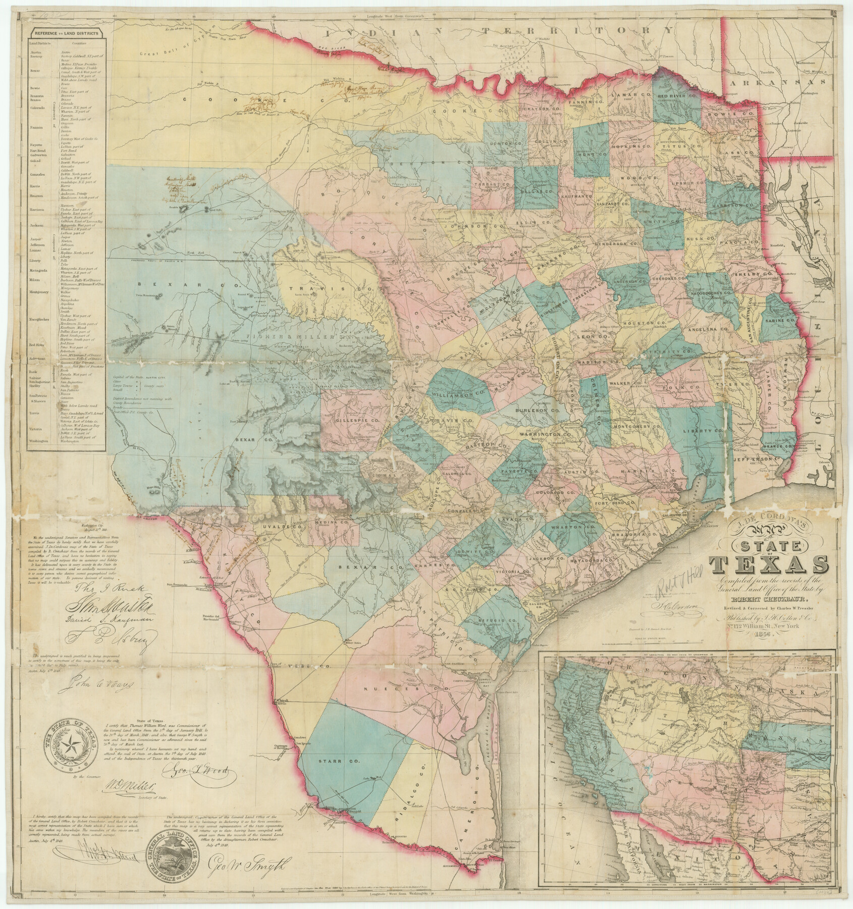
J. De Cordova's Map of the State of Texas Compiled from the records of the General Land Office of the State
K-4-12
-
Map/Doc
76222
-
Collection
Texas State Library and Archives
-
Object Dates
1856 (Creation Date)
-
People and Organizations
J. H. Colton and Company (Publisher)
Robert Creuzbaur (Draftsman)
Jacob De Cordova (Author)
Robert Creuzbaur (Compiler)
Chas. W. Pressler (Draftsman)
-
Subjects
State of Texas
-
Height x Width
34.2 x 32.1 inches
86.9 x 81.5 cm
-
Comments
Prints available courtesy of the Texas State Library and Archives.
More info can be found here: TSLAC Map 01032
Part of: Texas State Library and Archives
General Highway Map. Detail of Cities and Towns in Travis County, Texas. City Map, Austin and vicinity, Travis County, Texas

Print $20.00
General Highway Map. Detail of Cities and Towns in Travis County, Texas. City Map, Austin and vicinity, Travis County, Texas
1961
Size 18.2 x 24.9 inches
Map/Doc 79684
General Highway Map, Hidalgo County, Texas

Print $20.00
General Highway Map, Hidalgo County, Texas
1940
Size 18.4 x 24.7 inches
Map/Doc 79127
General Highway Map, Kimble County, Texas

Print $20.00
General Highway Map, Kimble County, Texas
1940
Size 24.8 x 18.3 inches
Map/Doc 79160
General Highway Map, El Paso County, Texas

Print $20.00
General Highway Map, El Paso County, Texas
1961
Size 18.2 x 24.7 inches
Map/Doc 79454
Map of the City of San Antonio

Print $20.00
Map of the City of San Antonio
1909
Size 28.3 x 28.6 inches
Map/Doc 76293
Town of Lubbock, Texas and Additions

Print $20.00
Town of Lubbock, Texas and Additions
1935
Size 43.8 x 43.5 inches
Map/Doc 76271
General Highway Map, Lynn County, Texas

Print $20.00
General Highway Map, Lynn County, Texas
1961
Size 18.1 x 24.6 inches
Map/Doc 79580
General Highway Map, San Augustine County, Texas

Print $20.00
General Highway Map, San Augustine County, Texas
1940
Size 24.8 x 18.3 inches
Map/Doc 79235
Map of the United States of America with its territories and districts including also a part of upper and lower Canada and Mexico

Print $20.00
Map of the United States of America with its territories and districts including also a part of upper and lower Canada and Mexico
1835
Size 30.3 x 43.2 inches
Map/Doc 79728

General Highway Map, Hall County, Texas

Print $20.00
General Highway Map, Hall County, Texas
1940
Size 18.3 x 25.0 inches
Map/Doc 79110
Map of the Texas and Pacific Railway and Connections

Print $20.00
Map of the Texas and Pacific Railway and Connections
1897
Size 19.3 x 24.4 inches
Map/Doc 79328
You may also like
[Western part of Crockett County]
![90323, [Western part of Crockett County], Twichell Survey Records](https://historictexasmaps.com/wmedia_w700/maps/90323-1.tif.jpg)
Print $20.00
- Digital $50.00
[Western part of Crockett County]
Size 17.3 x 14.3 inches
Map/Doc 90323
Gonzales County Boundary File 34 (9)

Print $18.00
- Digital $50.00
Gonzales County Boundary File 34 (9)
Size 8.5 x 3.9 inches
Map/Doc 53836
Flight Mission No. DQO-7K, Frame 75, Galveston County

Print $20.00
- Digital $50.00
Flight Mission No. DQO-7K, Frame 75, Galveston County
1952
Size 18.9 x 22.4 inches
Map/Doc 85102

Duval County Working Sketch 52

Print $20.00
- Digital $50.00
Duval County Working Sketch 52
1942
Size 22.1 x 25.9 inches
Map/Doc 68776
[E. L. & R. R. RR. Co. Block D7 and G. H. & H. RR. Co. Block A1]
![91859, [E. L. & R. R. RR. Co. Block D7 and G. H. & H. RR. Co. Block A1], Twichell Survey Records](https://historictexasmaps.com/wmedia_w700/maps/91859-1.tif.jpg)
Print $20.00
- Digital $50.00
[E. L. & R. R. RR. Co. Block D7 and G. H. & H. RR. Co. Block A1]
Size 19.0 x 25.2 inches
Map/Doc 91859
Karnes County Working Sketch 14

Print $3.00
- Digital $50.00
Karnes County Working Sketch 14
1981
Size 16.9 x 9.3 inches
Map/Doc 66662

Tom Green County Sketch File 55 1/2

Print $20.00
- Digital $50.00
Tom Green County Sketch File 55 1/2
1886
Size 26.4 x 13.6 inches
Map/Doc 12443
J. De Cordova's Map of the State of Texas Compiled from the records of the General Land Office of the State

Print $20.00
- Digital $50.00
J. De Cordova's Map of the State of Texas Compiled from the records of the General Land Office of the State
1854
Size 25.6 x 23.4 inches
Map/Doc 93903
Map of Webb Co.

Print $20.00
- Digital $50.00
Map of Webb Co.
1901
Size 40.4 x 47.1 inches
Map/Doc 16919
[North part] Cass County
![90385, [North part] Cass County, Twichell Survey Records](https://historictexasmaps.com/wmedia_w700/maps/90385-1.tif.jpg)
Print $20.00
- Digital $50.00
[North part] Cass County
1896
Size 37.3 x 19.5 inches
Map/Doc 90385