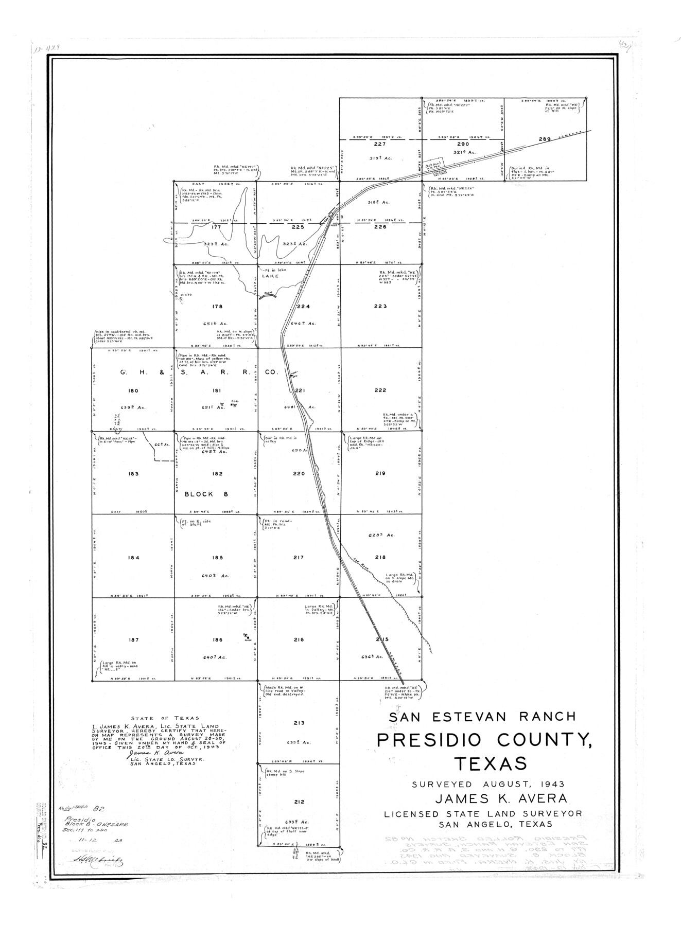
Presidio County Rolled Sketch 82
San Estevan Ranch, Presidio County, Texas
-
Map/Doc
7369
-
Collection
General Map Collection
-
Object Dates
1943/8/30 (Survey Date)
1943/11/12 (File Date)
1943/10/20 (Creation Date)
-
People and Organizations
James K Avera (Surveyor/Engineer)
-
Counties
Presidio
-
Subjects
Surveying Rolled Sketch
-
Height x Width
35.5 x 26.1 inches
90.2 x 66.3 cm
Part of: General Map Collection
Pecos County Sketch File 7

Print $20.00
- Digital $50.00
Pecos County Sketch File 7
Size 29.7 x 44.5 inches
Map/Doc 10568
Pecos County Sketch File 13

Print $20.00
- Digital $50.00
Pecos County Sketch File 13
Size 22.7 x 18.8 inches
Map/Doc 12156
Sherman County Boundary File 4

Print $54.00
- Digital $50.00
Sherman County Boundary File 4
Size 8.9 x 8.5 inches
Map/Doc 58782
Upshur County Sketch File 7

Print $4.00
- Digital $50.00
Upshur County Sketch File 7
1849
Size 8.2 x 10.2 inches
Map/Doc 38744
Glasscock County Working Sketch 4

Print $20.00
- Digital $50.00
Glasscock County Working Sketch 4
Size 15.7 x 25.9 inches
Map/Doc 63177
Schleicher County Sketch File 37

Print $20.00
- Digital $50.00
Schleicher County Sketch File 37
1952
Size 24.9 x 29.3 inches
Map/Doc 12310
Crockett County Sketch File 57

Print $22.00
- Digital $50.00
Crockett County Sketch File 57
Size 12.2 x 8.9 inches
Map/Doc 19832
Val Verde County Rolled Sketch 65

Print $20.00
- Digital $50.00
Val Verde County Rolled Sketch 65
1956
Size 43.0 x 45.0 inches
Map/Doc 10083
Jefferson County Boundary File 1

Print $10.00
- Digital $50.00
Jefferson County Boundary File 1
Size 9.8 x 6.7 inches
Map/Doc 55514
Sketch of part of Brazos Island

Print $20.00
- Digital $50.00
Sketch of part of Brazos Island
1863
Size 25.1 x 18.2 inches
Map/Doc 72923
Lynn County Working Sketch 5

Print $20.00
- Digital $50.00
Lynn County Working Sketch 5
1982
Size 22.5 x 28.2 inches
Map/Doc 70675
Flight Mission No. BRA-16M, Frame 60, Jefferson County

Print $20.00
- Digital $50.00
Flight Mission No. BRA-16M, Frame 60, Jefferson County
1953
Size 18.6 x 22.3 inches
Map/Doc 85677
You may also like
Kaufman County Working Sketch 1

Print $20.00
- Digital $50.00
Kaufman County Working Sketch 1
1921
Size 21.4 x 47.6 inches
Map/Doc 66664
Presidio County Working Sketch 124

Print $20.00
- Digital $50.00
Presidio County Working Sketch 124
1984
Size 30.8 x 24.3 inches
Map/Doc 71802
Sketch for Mineral Application 26543 (D. H. Sanford) - 243.37 Acres

Print $3.00
- Digital $50.00
Sketch for Mineral Application 26543 (D. H. Sanford) - 243.37 Acres
1931
Size 16.6 x 3.7 inches
Map/Doc 65679

Plat of Resurvey of Section 36, T. 4S., R. 14W., Indian Meridian, Oklahoma

Print $4.00
- Digital $50.00
Plat of Resurvey of Section 36, T. 4S., R. 14W., Indian Meridian, Oklahoma
1917
Size 18.1 x 22.6 inches
Map/Doc 75152
Chart of the Rio Bravo del Norte traced from a survey made by Henry Austin by Lieut. Bowman, 3d. Infy.

Print $20.00
- Digital $50.00
Chart of the Rio Bravo del Norte traced from a survey made by Henry Austin by Lieut. Bowman, 3d. Infy.
1866
Size 18.1 x 27.2 inches
Map/Doc 72890
Bandera County Sketch File 9

Print $2.00
- Digital $50.00
Bandera County Sketch File 9
Size 8.7 x 4.9 inches
Map/Doc 14009
Nueces County NRC Article 33.136 Sketch 23

Print $42.00
Nueces County NRC Article 33.136 Sketch 23
2023
Map/Doc 97181
Ector County Sketch File 5

Print $6.00
- Digital $50.00
Ector County Sketch File 5
1939
Size 9.1 x 14.5 inches
Map/Doc 21637
Wharton County Working Sketch 3

Print $20.00
- Digital $50.00
Wharton County Working Sketch 3
Size 17.5 x 16.4 inches
Map/Doc 72467
A Map of the Internal Provinces of New Spain

Print $20.00
A Map of the Internal Provinces of New Spain
1807
Size 18.9 x 19.5 inches
Map/Doc 76234
Map [showing surveys 820-829] Along Red River
![89813, Map [showing surveys 820-829] Along Red River, Twichell Survey Records](https://historictexasmaps.com/wmedia_w700/maps/89813-1.tif.jpg)
Print $20.00
- Digital $50.00
Map [showing surveys 820-829] Along Red River
1920
Size 40.4 x 45.2 inches
Map/Doc 89813