Treaty to Resolve Pending Boundary Differences and Maintain the Rio Grande and Colorado River as the International Boundary Between the United States of American and Mexico
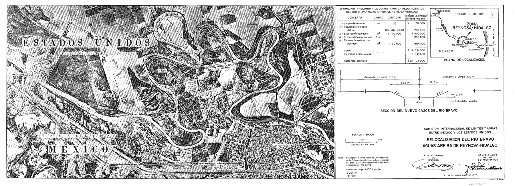
Comision Internacional de Limites y Aguas Entre Mexico y Los Estados Unidos Relocalizacion del Rio Bravo Aguas Arriba de Reynosa - Hidalgo
-
Map/Doc
83106
-
Collection
General Map Collection
-
Object Dates
1970/12/12 (Creation Date)
-
People and Organizations
United States Department of State (Publisher)
U. S. Government Printing Office (Printer)
-
Subjects
Texas Boundaries
-
Height x Width
10.8 x 29.8 inches
27.4 x 75.7 cm
-
Medium
sketch
Part of: General Map Collection
Maps of Gulf Intracoastal Waterway, Texas - Sabine River to the Rio Grande and connecting waterways including ship channels

Print $20.00
- Digital $50.00
Maps of Gulf Intracoastal Waterway, Texas - Sabine River to the Rio Grande and connecting waterways including ship channels
1966
Size 14.6 x 22.3 inches
Map/Doc 61938
Lubbock County Working Sketch 10

Print $20.00
- Digital $50.00
Lubbock County Working Sketch 10
1994
Size 21.8 x 30.1 inches
Map/Doc 70670
Navigation Maps of Gulf Intracoastal Waterway, Port Arthur to Brownsville, Texas

Print $4.00
- Digital $50.00
Navigation Maps of Gulf Intracoastal Waterway, Port Arthur to Brownsville, Texas
1951
Size 16.6 x 21.6 inches
Map/Doc 65422
[Sketch for Mineral Application 31137 - Colorado River, W. A. Wagner]
![65633, [Sketch for Mineral Application 31137 - Colorado River, W. A. Wagner], General Map Collection](https://historictexasmaps.com/wmedia_w700/maps/65633.tif.jpg)
Print $40.00
- Digital $50.00
[Sketch for Mineral Application 31137 - Colorado River, W. A. Wagner]
1928
Size 39.6 x 126.4 inches
Map/Doc 65633
University Land, Pecos County, Texas

Print $20.00
- Digital $50.00
University Land, Pecos County, Texas
1932
Size 35.7 x 47.5 inches
Map/Doc 2433
Lee County Rolled Sketch 2

Print $20.00
- Digital $50.00
Lee County Rolled Sketch 2
1976
Size 25.9 x 34.4 inches
Map/Doc 6593
Baylor County Sketch File 13

Print $4.00
- Digital $50.00
Baylor County Sketch File 13
1856
Size 13.5 x 8.5 inches
Map/Doc 14179
Gregg County Working Sketch 17

Print $20.00
- Digital $50.00
Gregg County Working Sketch 17
1950
Size 29.7 x 26.2 inches
Map/Doc 63284
Reconnaissance of Aransas Pass, Texas

Print $20.00
- Digital $50.00
Reconnaissance of Aransas Pass, Texas
1852
Size 14.4 x 13.6 inches
Map/Doc 76171
Dickens County Rolled Sketch P

Print $20.00
- Digital $50.00
Dickens County Rolled Sketch P
1917
Size 41.2 x 36.9 inches
Map/Doc 8782
A Map of the Republic of Texas and the adjacent territories, indicating the grants of land conceded under the empresario system of Mexico

Print $20.00
- Digital $50.00
A Map of the Republic of Texas and the adjacent territories, indicating the grants of land conceded under the empresario system of Mexico
1841
Size 13.8 x 16.6 inches
Map/Doc 93752
Runnels County Sketch File 39

Print $20.00
Runnels County Sketch File 39
1891
Size 25.2 x 19.1 inches
Map/Doc 12270
You may also like
Palo Pinto County Working Sketch 7

Print $20.00
- Digital $50.00
Palo Pinto County Working Sketch 7
1922
Map/Doc 71390

Anderson County Working Sketch 10

Print $20.00
- Digital $50.00
Anderson County Working Sketch 10
1933
Size 31.0 x 48.5 inches
Map/Doc 67009
Flight Mission No. DCL-7C, Frame 139, Kenedy County

Print $20.00
- Digital $50.00
Flight Mission No. DCL-7C, Frame 139, Kenedy County
1943
Size 18.5 x 22.3 inches
Map/Doc 86096
[Texas Boundary Line]
![92072, [Texas Boundary Line], Twichell Survey Records](https://historictexasmaps.com/wmedia_w700/maps/92072-1.tif.jpg)
Print $20.00
- Digital $50.00
[Texas Boundary Line]
Size 21.6 x 12.9 inches
Map/Doc 92072
General Highway Map, King County, Texas

Print $20.00
General Highway Map, King County, Texas
1940
Size 18.3 x 24.8 inches
Map/Doc 79161
[Southern Pacific Rail Road Co. Blocks 15 and 16 in Mitchell, Sterling and Coke Counties]
![91838, [Southern Pacific Rail Road Co. Blocks 15 and 16 in Mitchell, Sterling and Coke Counties], Twichell Survey Records](https://historictexasmaps.com/wmedia_w700/maps/91838-1.tif.jpg)
Print $20.00
- Digital $50.00
[Southern Pacific Rail Road Co. Blocks 15 and 16 in Mitchell, Sterling and Coke Counties]
Size 34.5 x 29.2 inches
Map/Doc 91838
[Sketch for Mineral Application 26649-26650 - Sabine River, Harry A. Wolan]
![65565, [Sketch for Mineral Application 26649-26650 - Sabine River, Harry A. Wolan], General Map Collection](https://historictexasmaps.com/wmedia_w700/maps/65565.tif.jpg)
Print $40.00
- Digital $50.00
[Sketch for Mineral Application 26649-26650 - Sabine River, Harry A. Wolan]
Size 36.8 x 71.9 inches
Map/Doc 65565
Crockett County

Print $40.00
- Digital $50.00
Crockett County
1882
Size 57.6 x 31.6 inches
Map/Doc 88865
Flight Mission No. CUG-3P, Frame 77, Kleberg County

Print $20.00
- Digital $50.00
Flight Mission No. CUG-3P, Frame 77, Kleberg County
1956
Size 18.7 x 22.4 inches
Map/Doc 86252
Flight Mission No. DQN-5K, Frame 149, Calhoun County

Print $20.00
- Digital $50.00
Flight Mission No. DQN-5K, Frame 149, Calhoun County
1953
Size 18.5 x 22.2 inches
Map/Doc 84424
Zavala County Sketch File 37

Print $4.00
- Digital $50.00
Zavala County Sketch File 37
Size 12.9 x 8.1 inches
Map/Doc 41402