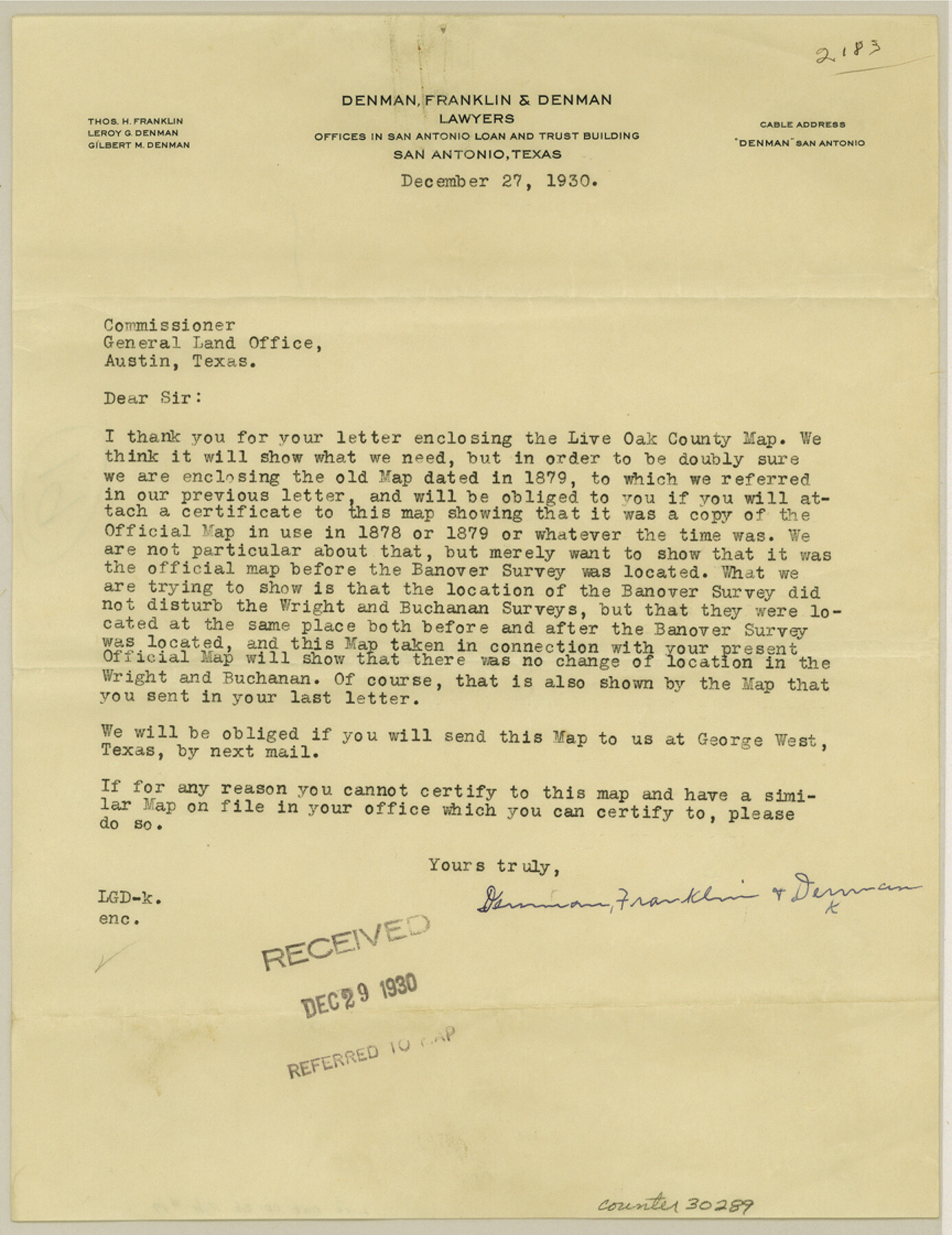
Live Oak County Sketch File 19
[Letter that accompanied map of Live Oak County]
-
Map/Doc
30289
-
Collection
General Map Collection
-
Object Dates
12/27/1930 (Creation Date)
12/29/1930 (File Date)
12/27/1930 (Correspondence Date)
-
People and Organizations
Denman, Franklin & Denman (Attorney)
-
Counties
Live Oak
-
Subjects
Surveying Sketch File
-
Height x Width
11.2 x 8.6 inches
28.5 x 21.8 cm
-
Medium
paper, print
-
Comments
See Live Oak County Sketch File 19 (4580) for map.
Related maps
Live Oak County Sketch File 19

Print $20.00
- Digital $50.00
Live Oak County Sketch File 19
1879
Size 24.7 x 18.3 inches
Map/Doc 4580
Part of: General Map Collection
San Saba County Working Sketch 7

Print $20.00
- Digital $50.00
San Saba County Working Sketch 7
1952
Size 35.5 x 29.1 inches
Map/Doc 63795
Llano County Sketch File 6

Print $8.00
- Digital $50.00
Llano County Sketch File 6
1877
Size 9.4 x 7.9 inches
Map/Doc 30358
Fannin County Sketch File 3

Print $4.00
- Digital $50.00
Fannin County Sketch File 3
Size 9.3 x 8.3 inches
Map/Doc 22447
Henderson County Working Sketch 20

Print $20.00
- Digital $50.00
Henderson County Working Sketch 20
1947
Size 31.6 x 18.9 inches
Map/Doc 66153
Hale County Rolled Sketch 6

Print $20.00
- Digital $50.00
Hale County Rolled Sketch 6
1903
Size 35.0 x 28.9 inches
Map/Doc 6045
Culberson County Working Sketch 41

Print $20.00
- Digital $50.00
Culberson County Working Sketch 41
1970
Size 22.9 x 42.6 inches
Map/Doc 68495
Wilbarger County Sketch File 1

Print $4.00
- Digital $50.00
Wilbarger County Sketch File 1
Size 8.2 x 12.8 inches
Map/Doc 40162
Classification of Blocks 1 to 58, Set Apart to University by Constitution of 1876 by M. B. Moore

Classification of Blocks 1 to 58, Set Apart to University by Constitution of 1876 by M. B. Moore
Map/Doc 81726
Van Zandt County Rolled Sketch 8

Print $20.00
- Digital $50.00
Van Zandt County Rolled Sketch 8
1948
Size 38.4 x 23.9 inches
Map/Doc 8148
Rusk County Sketch File 8

Print $4.00
Rusk County Sketch File 8
1856
Size 12.7 x 8.2 inches
Map/Doc 35503
Township 12 North Range 16 West, North Western District, Louisiana

Print $20.00
- Digital $50.00
Township 12 North Range 16 West, North Western District, Louisiana
1837
Size 19.7 x 24.8 inches
Map/Doc 65868
Pecos County Rolled Sketch 34

Print $20.00
- Digital $50.00
Pecos County Rolled Sketch 34
1891
Size 26.1 x 40.4 inches
Map/Doc 7215
You may also like
Orange County Boundary File 8

Print $4.00
- Digital $50.00
Orange County Boundary File 8
Size 11.9 x 7.6 inches
Map/Doc 57780


Starr County Sketch File 5

Print $40.00
- Digital $50.00
Starr County Sketch File 5
Size 31.4 x 40.7 inches
Map/Doc 82571
Upton County Working Sketch 49B

Print $20.00
- Digital $50.00
Upton County Working Sketch 49B
1979
Size 19.0 x 32.0 inches
Map/Doc 69546
Matagorda County Sketch File 30

Print $20.00
- Digital $50.00
Matagorda County Sketch File 30
1911
Size 22.2 x 31.9 inches
Map/Doc 12045
Brazoria County Boundary File 1

Print $10.00
- Digital $50.00
Brazoria County Boundary File 1
Size 14.4 x 8.7 inches
Map/Doc 50699
Liberty County Sketch File 28

Print $6.00
- Digital $50.00
Liberty County Sketch File 28
Size 5.2 x 8.0 inches
Map/Doc 29952
[Subdivision of Crockett County School Land Lgs. 214-217]
![90106, [Subdivision of Crockett County School Land Lgs. 214-217], Twichell Survey Records](https://historictexasmaps.com/wmedia_w700/maps/90106-1.tif.jpg)
Print $2.00
- Digital $50.00
[Subdivision of Crockett County School Land Lgs. 214-217]
Size 12.4 x 8.5 inches
Map/Doc 90106
Flight Mission No. DCL-4C, Frame 146, Kenedy County

Print $20.00
- Digital $50.00
Flight Mission No. DCL-4C, Frame 146, Kenedy County
1943
Size 18.6 x 22.3 inches
Map/Doc 85824
Williamson County Working Sketch 9

Print $20.00
- Digital $50.00
Williamson County Working Sketch 9
1954
Size 31.2 x 30.0 inches
Map/Doc 72569
Trinity River, McKinney Sheet/East Fork of Trinity River

Print $20.00
- Digital $50.00
Trinity River, McKinney Sheet/East Fork of Trinity River
1931
Size 40.6 x 28.0 inches
Map/Doc 65241