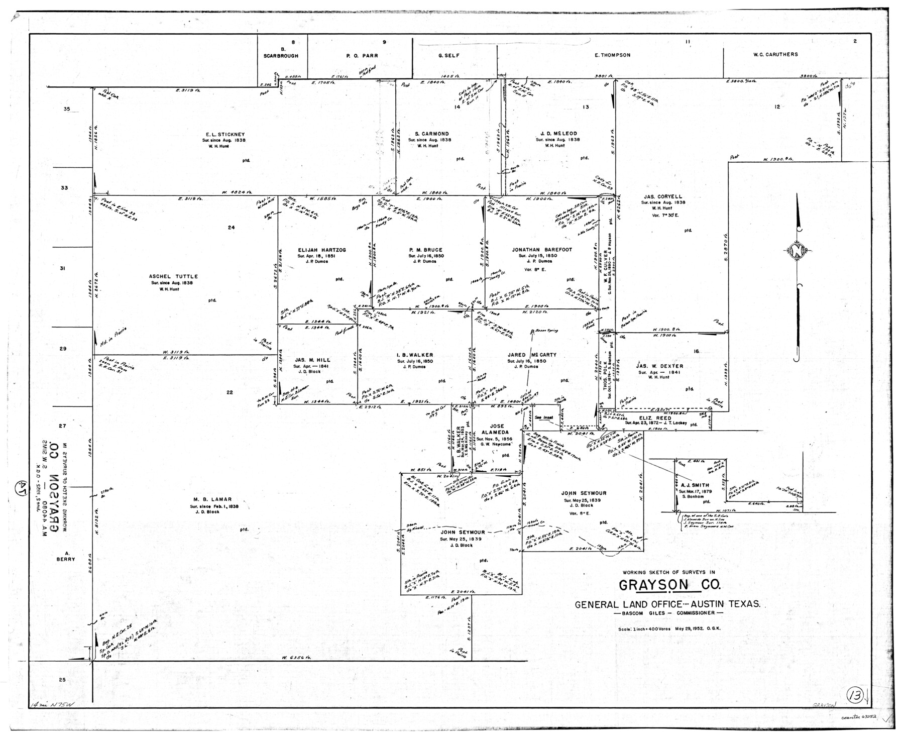
Grayson County Working Sketch 13
-
Map/Doc
63252
-
Collection
General Map Collection
-
Object Dates
5/29/1952 (Creation Date)
-
People and Organizations
Otto G. Kurio (Draftsman)
-
Counties
Grayson
-
Subjects
Surveying Working Sketch
-
Height x Width
31.1 x 38.0 inches
79.0 x 96.5 cm
-
Scale
1" = 400 varas
Part of: General Map Collection


Kaufman County Sketch File 14

Print $4.00
- Digital $50.00
Kaufman County Sketch File 14
Size 10.1 x 8.1 inches
Map/Doc 28649
Bell County Working Sketch 18

Print $20.00
- Digital $50.00
Bell County Working Sketch 18
1984
Size 36.2 x 29.8 inches
Map/Doc 67358
Hardin County Sketch File 55

Print $40.00
- Digital $50.00
Hardin County Sketch File 55
1924
Size 14.2 x 13.3 inches
Map/Doc 25220
Howard County Sketch File 2a

Print $20.00
- Digital $50.00
Howard County Sketch File 2a
1909
Size 32.8 x 25.6 inches
Map/Doc 11792
Gonzales County Sketch File 4a

Print $4.00
- Digital $50.00
Gonzales County Sketch File 4a
1861
Size 8.0 x 6.7 inches
Map/Doc 24375
King County Boundary File 5a

Print $40.00
- Digital $50.00
King County Boundary File 5a
Size 10.3 x 38.1 inches
Map/Doc 64922
Jefferson County NRC Article 33.136 Sketch 8

Print $20.00
- Digital $50.00
Jefferson County NRC Article 33.136 Sketch 8
2007
Size 20.1 x 18.7 inches
Map/Doc 87503
Pecos County Working Sketch 25

Print $20.00
- Digital $50.00
Pecos County Working Sketch 25
1929
Size 28.9 x 21.1 inches
Map/Doc 71496
La Salle County Sketch File 3

Print $44.00
- Digital $50.00
La Salle County Sketch File 3
1875
Size 15.8 x 29.6 inches
Map/Doc 11978
Calhoun County Working Sketch 13

Print $20.00
- Digital $50.00
Calhoun County Working Sketch 13
1962
Size 28.5 x 31.9 inches
Map/Doc 67829
You may also like
Eastland County Working Sketch 16

Print $20.00
- Digital $50.00
Eastland County Working Sketch 16
1919
Size 19.1 x 16.7 inches
Map/Doc 68797
Limestone County Sketch File 23

Print $6.00
- Digital $50.00
Limestone County Sketch File 23
1908
Size 10.9 x 7.1 inches
Map/Doc 30203
Controlled Mosaic by Jack Amman Photogrammetric Engineers, Inc - Sheet 21

Print $20.00
- Digital $50.00
Controlled Mosaic by Jack Amman Photogrammetric Engineers, Inc - Sheet 21
1954
Size 20.0 x 24.0 inches
Map/Doc 83470
Travis County Sketch File 3

Print $4.00
- Digital $50.00
Travis County Sketch File 3
Size 12.9 x 7.9 inches
Map/Doc 38273
Tom Green County Sketch File 39

Print $40.00
- Digital $50.00
Tom Green County Sketch File 39
1881
Size 14.8 x 18.6 inches
Map/Doc 76002
Flight Mission No. CUG-1P, Frame 47, Kleberg County

Print $20.00
- Digital $50.00
Flight Mission No. CUG-1P, Frame 47, Kleberg County
1956
Size 18.7 x 22.4 inches
Map/Doc 86125
Crockett County Rolled Sketch 93

Print $20.00
- Digital $50.00
Crockett County Rolled Sketch 93
1979
Size 18.8 x 18.9 inches
Map/Doc 5633
[Surveys along Rabb's Creek]
![154, [Surveys along Rabb's Creek], General Map Collection](https://historictexasmaps.com/wmedia_w700/maps/154.tif.jpg)
Print $2.00
- Digital $50.00
[Surveys along Rabb's Creek]
1841
Size 8.7 x 11.0 inches
Map/Doc 154
Hardeman County Working Sketch 6

Print $20.00
- Digital $50.00
Hardeman County Working Sketch 6
1944
Size 25.9 x 17.8 inches
Map/Doc 63387
Sabine County Sketch File 1

Print $2.00
Sabine County Sketch File 1
Size 14.2 x 7.7 inches
Map/Doc 35601
Capitol Syndicate Subdivision of Capitol Land Reservation Leagues Number 153, 154, 155, 156, 157, 158, 167, 168, 169, 170, 171, and 172 and Parts of Leagues 143, 144, 145, 146, 152, 159, 166, and 173

Print $20.00
- Digital $50.00
Capitol Syndicate Subdivision of Capitol Land Reservation Leagues Number 153, 154, 155, 156, 157, 158, 167, 168, 169, 170, 171, and 172 and Parts of Leagues 143, 144, 145, 146, 152, 159, 166, and 173
1908
Size 22.8 x 34.6 inches
Map/Doc 90735
Midland County Rolled Sketch 6

Print $20.00
- Digital $50.00
Midland County Rolled Sketch 6
1951
Size 39.8 x 28.6 inches
Map/Doc 6764