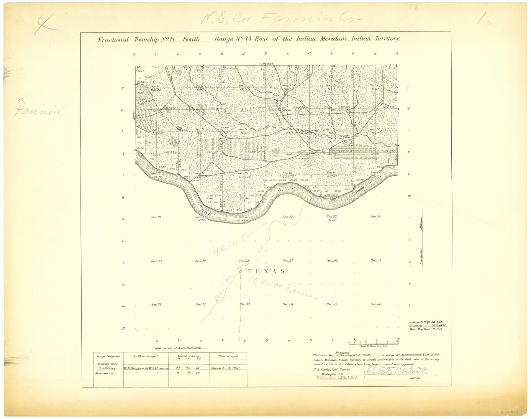
Fractional Township No. 8 South Range No. 14 East of the Indian Meridian, Indian Territory
-
Map/Doc
75225
-
Collection
General Map Collection
-
Object Dates
1896/3/6 (Creation Date)
-
Subjects
Texas Boundaries
-
Height x Width
19.2 x 24.3 inches
48.8 x 61.7 cm
Part of: General Map Collection
Map of Drum, Oyster & Bastrop Bays & vicinity in Brazoria County showing subdivision for mineral development

Print $20.00
- Digital $50.00
Map of Drum, Oyster & Bastrop Bays & vicinity in Brazoria County showing subdivision for mineral development
Size 36.8 x 47.3 inches
Map/Doc 65808
From Aransas Pass Eastward, Texas

Print $40.00
- Digital $50.00
From Aransas Pass Eastward, Texas
1866
Size 31.4 x 53.6 inches
Map/Doc 73426
Rockwall County Sketch File 7

Print $4.00
Rockwall County Sketch File 7
1873
Size 12.6 x 8.3 inches
Map/Doc 35427
[Beaumont, Sour Lake and Western Ry. Right of Way and Alignment - Frisco]
![64132, [Beaumont, Sour Lake and Western Ry. Right of Way and Alignment - Frisco], General Map Collection](https://historictexasmaps.com/wmedia_w700/maps/64132.tif.jpg)
Print $20.00
- Digital $50.00
[Beaumont, Sour Lake and Western Ry. Right of Way and Alignment - Frisco]
1910
Size 19.9 x 46.1 inches
Map/Doc 64132
Pecos County Sketch File 111

Print $18.00
- Digital $50.00
Pecos County Sketch File 111
Size 13.3 x 8.8 inches
Map/Doc 34052
San Jacinto County Working Sketch 3

Print $20.00
- Digital $50.00
San Jacinto County Working Sketch 3
1926
Size 16.7 x 19.7 inches
Map/Doc 63716
Map of the reconnaissance in Texas by Lieuts Blake & Meade of the Corps of Topl. Engs.

Print $20.00
- Digital $50.00
Map of the reconnaissance in Texas by Lieuts Blake & Meade of the Corps of Topl. Engs.
1846
Size 27.1 x 22.5 inches
Map/Doc 2003
Map of Crockett Co.

Print $20.00
- Digital $50.00
Map of Crockett Co.
1894
Size 32.6 x 44.1 inches
Map/Doc 4725
Culberson County Rolled Sketch 59

Print $40.00
- Digital $50.00
Culberson County Rolled Sketch 59
1974
Size 37.3 x 78.1 inches
Map/Doc 8760
St. Louis, Brownsville & Mexico Railway Location Map from Mile 0 to Mile 20

Print $40.00
- Digital $50.00
St. Louis, Brownsville & Mexico Railway Location Map from Mile 0 to Mile 20
1906
Size 19.5 x 74.5 inches
Map/Doc 64075
Duval County Rolled Sketch 19

Print $4.00
- Digital $50.00
Duval County Rolled Sketch 19
1940
Size 20.2 x 15.1 inches
Map/Doc 5740
Panola County Sketch File 21

Print $10.00
- Digital $50.00
Panola County Sketch File 21
Size 11.2 x 8.7 inches
Map/Doc 33487
You may also like
Map of Cameron, Hidalgo and half of Starr County of Texas

Print $20.00
- Digital $50.00
Map of Cameron, Hidalgo and half of Starr County of Texas
1942
Size 42.1 x 29.6 inches
Map/Doc 60401
Duval County Sketch File 57

Print $14.00
- Digital $50.00
Duval County Sketch File 57
1939
Size 14.2 x 8.9 inches
Map/Doc 21418
Concho County Rolled Sketch 4

Print $20.00
- Digital $50.00
Concho County Rolled Sketch 4
1948
Size 47.3 x 43.6 inches
Map/Doc 8649
Flight Mission No. BRE-1P, Frame 152, Nueces County

Print $20.00
- Digital $50.00
Flight Mission No. BRE-1P, Frame 152, Nueces County
1956
Size 18.4 x 22.3 inches
Map/Doc 86712
Grayson County Sketch File 28

Print $4.00
- Digital $50.00
Grayson County Sketch File 28
1990
Size 14.3 x 8.8 inches
Map/Doc 24517
Reeves County Working Sketch 64

Print $20.00
- Digital $50.00
Reeves County Working Sketch 64
1984
Size 26.3 x 26.5 inches
Map/Doc 63507
Hemphill County Working Sketch 14

Print $20.00
- Digital $50.00
Hemphill County Working Sketch 14
1969
Size 34.0 x 44.8 inches
Map/Doc 66109
[Surveys in the vicinity of Coyote Lake, Bailey County]
![90161, [Surveys in the vicinity of Coyote Lake, Bailey County], Twichell Survey Records](https://historictexasmaps.com/wmedia_w700/maps/90161-1.tif.jpg)
Print $20.00
- Digital $50.00
[Surveys in the vicinity of Coyote Lake, Bailey County]
1913
Size 26.8 x 26.7 inches
Map/Doc 90161
Reagan County Rolled Sketch 4

Print $20.00
- Digital $50.00
Reagan County Rolled Sketch 4
1928
Size 25.4 x 27.4 inches
Map/Doc 7433
Schleicher County Working Sketch 10

Print $20.00
- Digital $50.00
Schleicher County Working Sketch 10
1923
Size 18.3 x 16.4 inches
Map/Doc 63812
Anton Townsite Situated on Parts of Sections 106 and 113 Block A, R. M. Thomson, Grantee Hockley County, Texas

Print $20.00
- Digital $50.00
Anton Townsite Situated on Parts of Sections 106 and 113 Block A, R. M. Thomson, Grantee Hockley County, Texas
Size 30.7 x 34.5 inches
Map/Doc 92217
Brazos River, Brazos River Sheet 1

Print $20.00
- Digital $50.00
Brazos River, Brazos River Sheet 1
1926
Size 20.7 x 25.3 inches
Map/Doc 69665