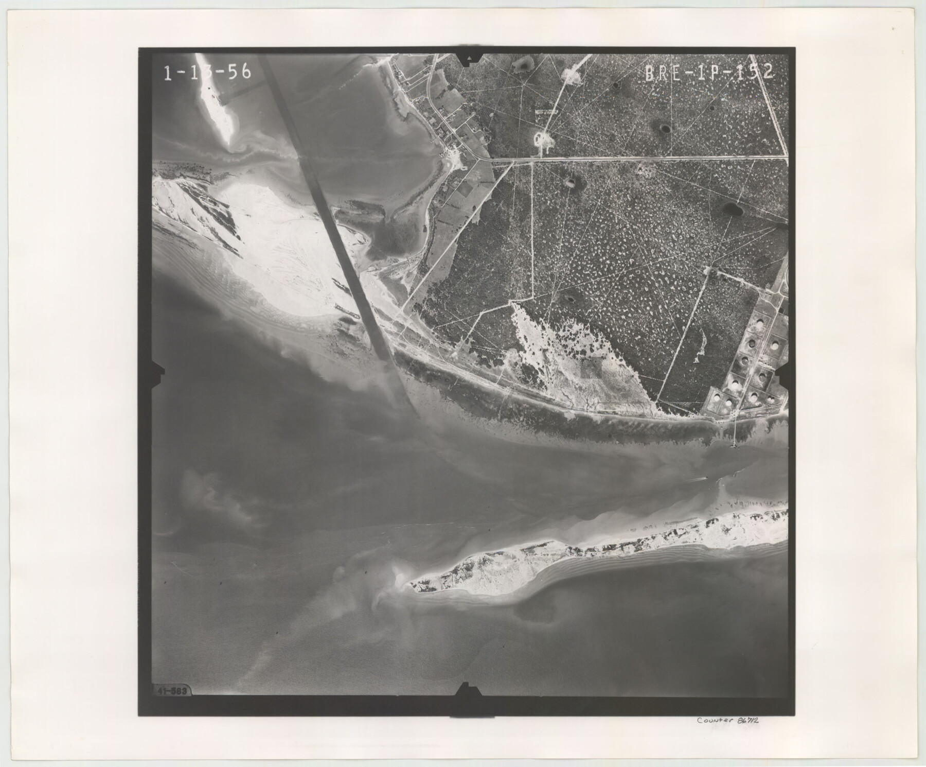
Flight Mission No. BRE-1P, Frame 152, Nueces County
BRE-1P-152
-
Map/Doc
86712
-
Collection
General Map Collection
-
Object Dates
1956/1/13 (Creation Date)
-
People and Organizations
U. S. Department of Agriculture (Publisher)
-
Counties
Nueces
-
Subjects
Aerial Photograph
-
Height x Width
18.4 x 22.3 inches
46.7 x 56.6 cm
-
Comments
Flown by V. L. Beavers and Associates of San Antonio, Texas.
Part of: General Map Collection
Flight Mission No. DCL-4C, Frame 5, Kenedy County

Print $20.00
- Digital $50.00
Flight Mission No. DCL-4C, Frame 5, Kenedy County
1943
Size 18.6 x 22.3 inches
Map/Doc 85806
Freestone County

Print $20.00
- Digital $50.00
Freestone County
1988
Size 45.8 x 42.6 inches
Map/Doc 73152

Flight Mission No. DCL-6C, Frame 173, Kenedy County

Print $20.00
- Digital $50.00
Flight Mission No. DCL-6C, Frame 173, Kenedy County
1943
Size 18.6 x 22.4 inches
Map/Doc 85985
Guadalupe County Sketch File 15e

Print $6.00
- Digital $50.00
Guadalupe County Sketch File 15e
Size 9.9 x 8.1 inches
Map/Doc 24707
Flight Mission No. CUG-1P, Frame 45, Kleberg County

Print $20.00
- Digital $50.00
Flight Mission No. CUG-1P, Frame 45, Kleberg County
1956
Size 18.5 x 22.2 inches
Map/Doc 86123
Wharton County Sketch File 9

Print $4.00
- Digital $50.00
Wharton County Sketch File 9
1884
Size 9.1 x 11.7 inches
Map/Doc 39929
Colorado County Working Sketch 14

Print $20.00
- Digital $50.00
Colorado County Working Sketch 14
1944
Size 30.8 x 21.6 inches
Map/Doc 68114
Galveston County Rolled Sketch DB

Print $20.00
- Digital $50.00
Galveston County Rolled Sketch DB
Size 37.0 x 47.5 inches
Map/Doc 9854
[Map of Texas and Indian Territory]
![93757, [Map of Texas and Indian Territory], General Map Collection](https://historictexasmaps.com/wmedia_w700/maps/93757-1.tif.jpg)
Print $20.00
- Digital $50.00
[Map of Texas and Indian Territory]
1878
Size 26.2 x 20.1 inches
Map/Doc 93757
Kinney County Sketch File 26

Print $20.00
- Digital $50.00
Kinney County Sketch File 26
1928
Size 20.4 x 18.8 inches
Map/Doc 11945
Dimmit County Sketch File 1

Print $42.00
- Digital $50.00
Dimmit County Sketch File 1
1851
Size 8.8 x 7.5 inches
Map/Doc 21050
You may also like
[Panhandle Counties]
![89951, [Panhandle Counties], Twichell Survey Records](https://historictexasmaps.com/wmedia_w700/maps/89951-1.tif.jpg)
Print $20.00
- Digital $50.00
[Panhandle Counties]
Size 41.8 x 43.2 inches
Map/Doc 89951
Howard County Working Sketch 8

Print $20.00
- Digital $50.00
Howard County Working Sketch 8
1956
Size 25.3 x 31.3 inches
Map/Doc 66275
[Sketch showing Block 42, Sections 221 and 222 and Block H, Sections 7 and 9]
![91714, [Sketch showing Block 42, Sections 221 and 222 and Block H, Sections 7 and 9], Twichell Survey Records](https://historictexasmaps.com/wmedia_w700/maps/91714-1.tif.jpg)
Print $2.00
- Digital $50.00
[Sketch showing Block 42, Sections 221 and 222 and Block H, Sections 7 and 9]
1919
Size 5.6 x 5.0 inches
Map/Doc 91714
Williamson County

Print $40.00
- Digital $50.00
Williamson County
1946
Size 40.1 x 57.7 inches
Map/Doc 63130
Kerr County Rolled Sketch 14

Print $20.00
- Digital $50.00
Kerr County Rolled Sketch 14
1951
Size 38.3 x 30.6 inches
Map/Doc 9345
Swisher County Sketch File 11

Print $58.00
- Digital $50.00
Swisher County Sketch File 11
1917
Size 9.1 x 8.3 inches
Map/Doc 37633
Flight Mission No. CUG-3P, Frame 140, Kleberg County

Print $20.00
- Digital $50.00
Flight Mission No. CUG-3P, Frame 140, Kleberg County
1956
Size 18.7 x 22.3 inches
Map/Doc 86275
Jim Nix Farm NW 1/4 Section 40, Block 1 Halsell Subdivision

Print $20.00
- Digital $50.00
Jim Nix Farm NW 1/4 Section 40, Block 1 Halsell Subdivision
Size 12.1 x 13.9 inches
Map/Doc 92400
San Patricio County Rolled Sketch 22

Print $20.00
- Digital $50.00
San Patricio County Rolled Sketch 22
1882
Size 19.3 x 23.9 inches
Map/Doc 7581
Castro County Rolled Sketch 12

Print $20.00
- Digital $50.00
Castro County Rolled Sketch 12
1945
Size 25.7 x 15.8 inches
Map/Doc 5421
Chart of the Harbour of San [Luis]
![72761, Chart of the Harbour of San [Luis], General Map Collection](https://historictexasmaps.com/wmedia_w700/maps/72761.tif.jpg)
Print $20.00
- Digital $50.00
Chart of the Harbour of San [Luis]
1846
Size 27.3 x 18.3 inches
Map/Doc 72761
Lynn County Rolled Sketch W

Print $20.00
- Digital $50.00
Lynn County Rolled Sketch W
Size 23.0 x 40.0 inches
Map/Doc 6655