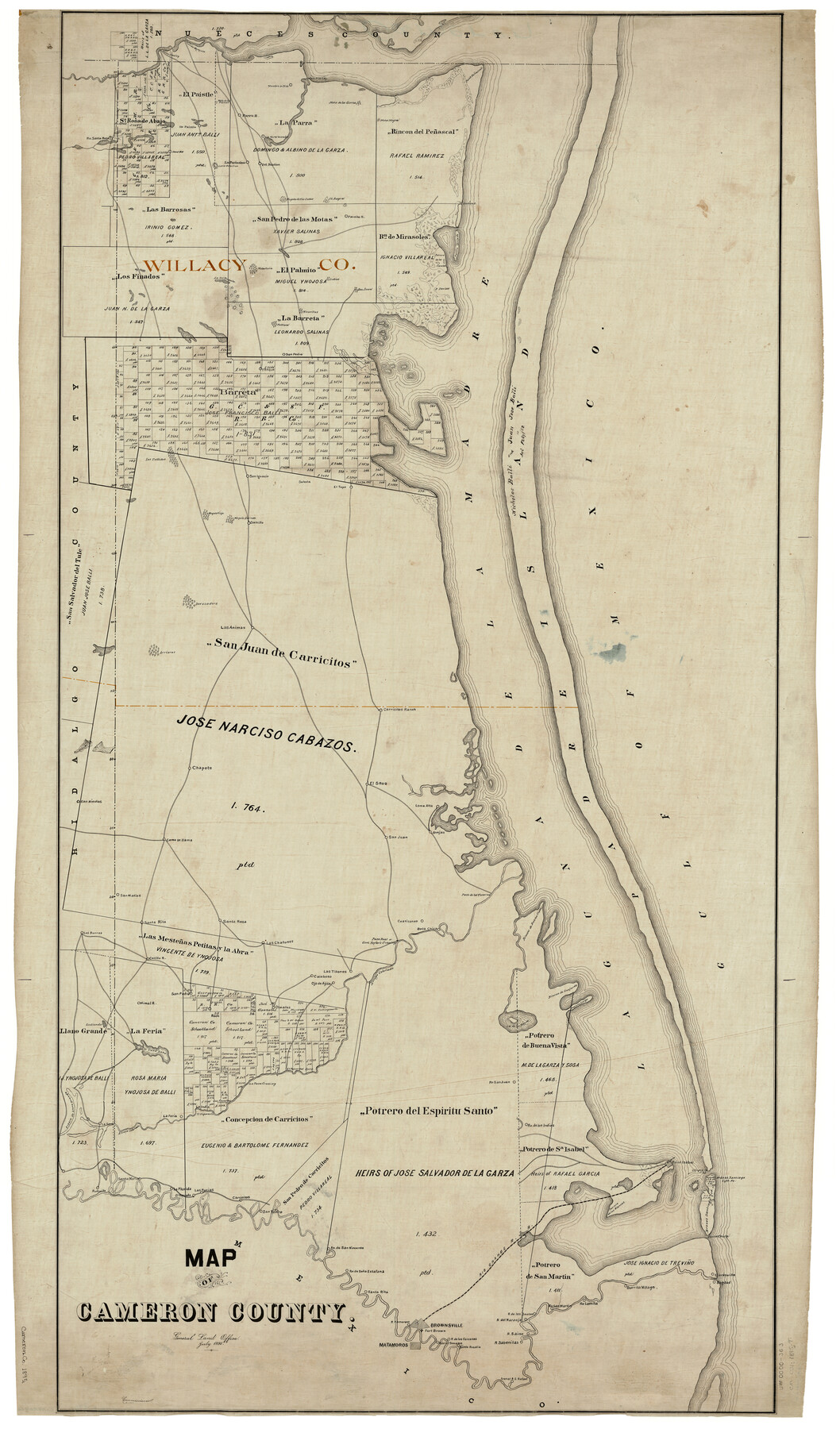
Map of Cameron County
-
Map/Doc
4901
-
Collection
General Map Collection
-
Object Dates
7/1895 (Creation Date)
-
Counties
Cameron
-
Subjects
County
-
Height x Width
48.9 x 28.9 inches
124.2 x 73.4 cm
Part of: General Map Collection
Flight Mission No. DAH-9M, Frame 163, Orange County

Print $20.00
- Digital $50.00
Flight Mission No. DAH-9M, Frame 163, Orange County
1953
Size 18.4 x 22.4 inches
Map/Doc 86862
Parker County Sketch File 19

Print $6.00
- Digital $50.00
Parker County Sketch File 19
1876
Size 11.7 x 10.3 inches
Map/Doc 33556
Padre Island National Seashore

Print $4.00
- Digital $50.00
Padre Island National Seashore
Size 16.0 x 22.2 inches
Map/Doc 60525
Kimble County Working Sketch 96

Print $20.00
- Digital $50.00
Kimble County Working Sketch 96
1921
Size 20.9 x 26.8 inches
Map/Doc 70164
Right-of-Way and Track Map, Houston and Brazos Valley Ry. Co. operated by the Houston and Brazos Valley Ry. Co.

Print $40.00
- Digital $50.00
Right-of-Way and Track Map, Houston and Brazos Valley Ry. Co. operated by the Houston and Brazos Valley Ry. Co.
1918
Size 24.9 x 56.6 inches
Map/Doc 64606
Flight Mission No. CUG-3P, Frame 33, Kleberg County

Print $20.00
- Digital $50.00
Flight Mission No. CUG-3P, Frame 33, Kleberg County
1956
Size 18.4 x 22.2 inches
Map/Doc 86238
Polk County Working Sketch 4

Print $20.00
- Digital $50.00
Polk County Working Sketch 4
1925
Size 46.3 x 42.6 inches
Map/Doc 71619
Tarrant County

Print $20.00
- Digital $50.00
Tarrant County
1873
Size 19.6 x 18.0 inches
Map/Doc 4630
Cameron County Rolled Sketch 10A

Print $71.00
- Digital $50.00
Cameron County Rolled Sketch 10A
Size 11.1 x 8.7 inches
Map/Doc 41749
Brewster County Sketch File N-11

Print $40.00
- Digital $50.00
Brewster County Sketch File N-11
Size 23.2 x 9.5 inches
Map/Doc 10965
McMullen County Working Sketch 45

Print $20.00
- Digital $50.00
McMullen County Working Sketch 45
1981
Size 47.6 x 38.5 inches
Map/Doc 70746
[Plat and field notes of 3.107 acre tract for Clement Cove Harbor Company]

Print $2.00
- Digital $50.00
[Plat and field notes of 3.107 acre tract for Clement Cove Harbor Company]
1987
Size 13.7 x 8.5 inches
Map/Doc 60398
You may also like
Navarro County Rolled Sketch 4

Print $20.00
- Digital $50.00
Navarro County Rolled Sketch 4
1953
Size 27.1 x 29.8 inches
Map/Doc 6839
Flight Mission No. BRA-17M, Frame 13, Jefferson County

Print $20.00
- Digital $50.00
Flight Mission No. BRA-17M, Frame 13, Jefferson County
1953
Size 18.6 x 22.3 inches
Map/Doc 85794
Harbor Pass and Bar at Brazos Santiago, Texas

Print $20.00
- Digital $50.00
Harbor Pass and Bar at Brazos Santiago, Texas
1871
Size 18.1 x 27.4 inches
Map/Doc 73038
Palo Pinto County Working Sketch 12

Print $20.00
- Digital $50.00
Palo Pinto County Working Sketch 12
1946
Size 21.1 x 33.7 inches
Map/Doc 71395
Fannin County Sketch File 21

Print $4.00
- Digital $50.00
Fannin County Sketch File 21
1878
Size 10.5 x 8.4 inches
Map/Doc 22487
Comanche County Working Sketch 20

Print $20.00
- Digital $50.00
Comanche County Working Sketch 20
1973
Size 20.5 x 15.6 inches
Map/Doc 68154
Chambers County

Print $20.00
- Digital $50.00
Chambers County
1862
Size 20.2 x 27.8 inches
Map/Doc 3381
Working Sketch Patents & Field Notes, Sabine Lake Area

Print $20.00
- Digital $50.00
Working Sketch Patents & Field Notes, Sabine Lake Area
1959
Size 30.2 x 27.0 inches
Map/Doc 2455
A Portion of Yoakum County, Texas and Gaines County, Texas in the vicinity of the Wasson Oil Field

Print $20.00
- Digital $50.00
A Portion of Yoakum County, Texas and Gaines County, Texas in the vicinity of the Wasson Oil Field
Size 43.4 x 32.0 inches
Map/Doc 90808
Archer County Working Sketch 3

Print $20.00
- Digital $50.00
Archer County Working Sketch 3
1913
Size 19.8 x 12.3 inches
Map/Doc 67143
Refugio County Sketch File 16

Print $4.00
- Digital $50.00
Refugio County Sketch File 16
Size 7.1 x 8.2 inches
Map/Doc 35270
Webb County Rolled Sketch 70

Print $20.00
- Digital $50.00
Webb County Rolled Sketch 70
Size 24.0 x 37.4 inches
Map/Doc 8217