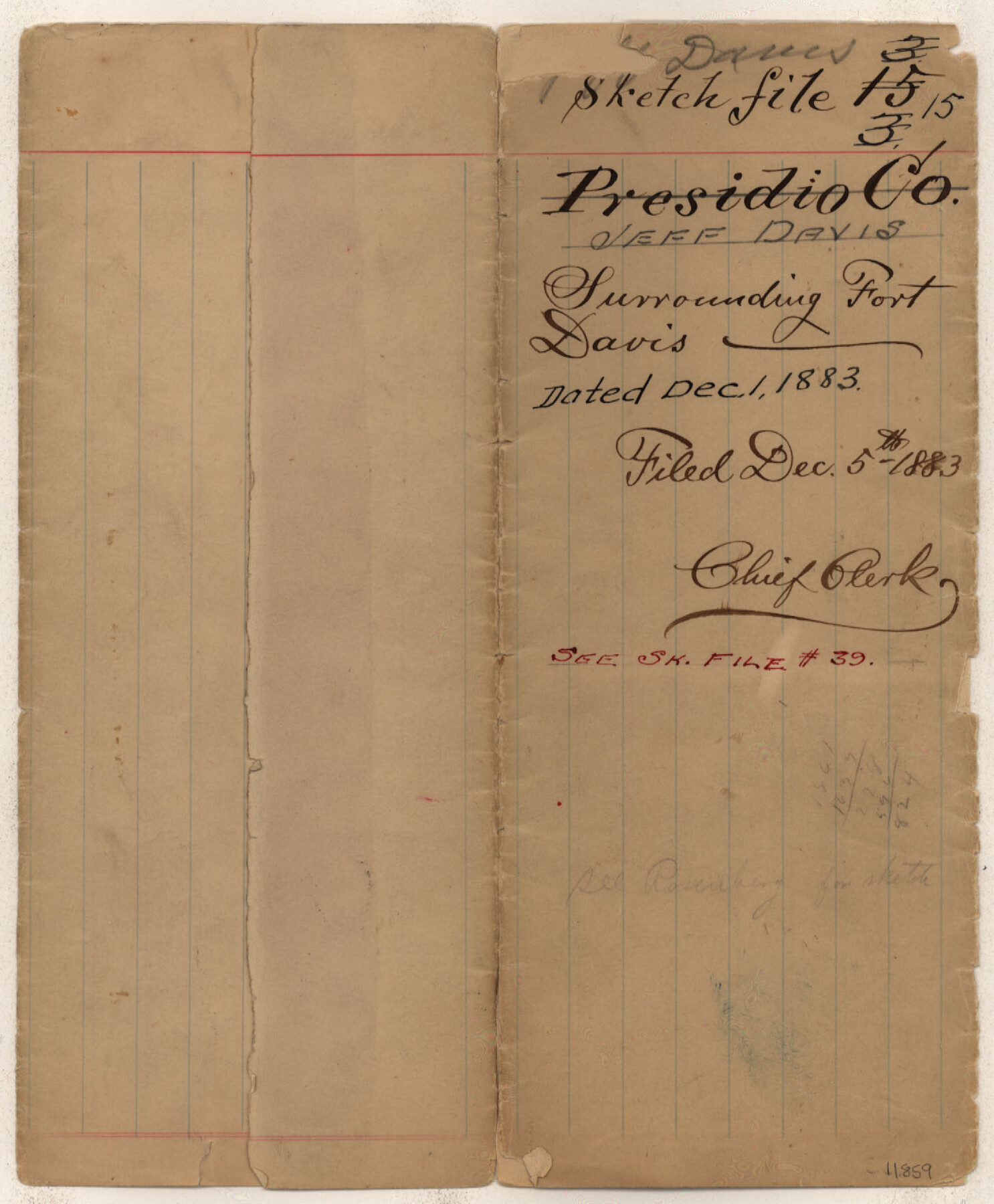
Jeff Davis County Sketch File 15
Map of a Part of Presidio County, Texas
-
Map/Doc
11859
-
Collection
General Map Collection
-
Object Dates
12/1/1883 (Creation Date)
12/5/1883 (File Date)
12/1/1883 (Survey Date)
-
People and Organizations
S.A. Thompson (Surveyor/Engineer)
-
Counties
Jeff Davis
-
Subjects
Surveying Sketch File
-
Height x Width
28.5 x 18.9 inches
72.4 x 48.0 cm
-
Medium
paper, manuscript
-
Comments
This sketch is located in present-day Jeff Davis County.
-
Features
Fort Davis
Part of: General Map Collection
Menard County Sketch File 22

Print $8.00
- Digital $50.00
Menard County Sketch File 22
1927
Size 7.4 x 8.6 inches
Map/Doc 31553
Map of the Fort Worth and Denver City Railway

Print $40.00
- Digital $50.00
Map of the Fort Worth and Denver City Railway
1873
Size 31.6 x 90.3 inches
Map/Doc 64778
San Jacinto County Rolled Sketch 14

Print $20.00
- Digital $50.00
San Jacinto County Rolled Sketch 14
1998
Size 30.0 x 42.7 inches
Map/Doc 7563
Montague County Working Sketch 45

Print $20.00
- Digital $50.00
Montague County Working Sketch 45
2013
Size 17.0 x 24.0 inches
Map/Doc 93649

Edwards County Working Sketch 131

Print $20.00
- Digital $50.00
Edwards County Working Sketch 131
1984
Size 21.0 x 18.6 inches
Map/Doc 69007
Map of Hill County Texas

Print $20.00
- Digital $50.00
Map of Hill County Texas
1886
Size 19.3 x 24.4 inches
Map/Doc 3673
Jackson County Working Sketch 7

Print $20.00
- Digital $50.00
Jackson County Working Sketch 7
1973
Size 35.7 x 27.1 inches
Map/Doc 66455
Hill County Sketch File 25

Print $4.00
- Digital $50.00
Hill County Sketch File 25
Size 7.9 x 10.9 inches
Map/Doc 26520
Hidalgo County

Print $20.00
- Digital $50.00
Hidalgo County
1863
Size 46.0 x 25.2 inches
Map/Doc 3668
Runnels County Rolled Sketch C

Print $20.00
- Digital $50.00
Runnels County Rolled Sketch C
1892
Size 16.0 x 21.0 inches
Map/Doc 7541
Clay County Boundary File 17

Print $8.00
- Digital $50.00
Clay County Boundary File 17
Size 13.8 x 8.4 inches
Map/Doc 51432
You may also like
Hardin County Rolled Sketch 10

Print $20.00
- Digital $50.00
Hardin County Rolled Sketch 10
1948
Size 23.7 x 33.0 inches
Map/Doc 6082

[E.L.R.R.R.R.Co. Blocks A-1, 1, H, Y, Public School Land Blocks C-40, C-41, C-39, C-42]
![92904, [E.L.R.R.R.R.Co. Blocks A-1, 1, H, Y, Public School Land Blocks C-40, C-41, C-39, C-42], Twichell Survey Records](https://historictexasmaps.com/wmedia_w700/maps/92904-1.tif.jpg)
Print $20.00
- Digital $50.00
[E.L.R.R.R.R.Co. Blocks A-1, 1, H, Y, Public School Land Blocks C-40, C-41, C-39, C-42]
Size 21.6 x 21.2 inches
Map/Doc 92904
Index to Titles, Field Notes, and Plats in the Spanish Archives

Index to Titles, Field Notes, and Plats in the Spanish Archives
1942
Size 17.5 x 10.1 inches
Map/Doc 94524
[Right of Way & Track Map, The Texas & Pacific Ry. Co. Main Line]
![64659, [Right of Way & Track Map, The Texas & Pacific Ry. Co. Main Line], General Map Collection](https://historictexasmaps.com/wmedia_w700/maps/64659.tif.jpg)
Print $20.00
- Digital $50.00
[Right of Way & Track Map, The Texas & Pacific Ry. Co. Main Line]
Size 11.0 x 18.4 inches
Map/Doc 64659
[Township 3 North, Block 33]
![91214, [Township 3 North, Block 33], Twichell Survey Records](https://historictexasmaps.com/wmedia_w700/maps/91214-1.tif.jpg)
Print $3.00
- Digital $50.00
[Township 3 North, Block 33]
Size 11.0 x 11.3 inches
Map/Doc 91214
San Patricio County Sketch File 33

Print $20.00
- Digital $50.00
San Patricio County Sketch File 33
1946
Size 15.5 x 31.0 inches
Map/Doc 12288
Eastland County Working Sketch 20

Print $20.00
- Digital $50.00
Eastland County Working Sketch 20
1920
Size 38.0 x 23.5 inches
Map/Doc 68801
Flight Mission No. CUG-3P, Frame 36, Kleberg County

Print $20.00
- Digital $50.00
Flight Mission No. CUG-3P, Frame 36, Kleberg County
1956
Size 18.4 x 22.1 inches
Map/Doc 86241
Reeves County Rolled Sketch 16

Print $20.00
- Digital $50.00
Reeves County Rolled Sketch 16
1963
Size 22.3 x 27.3 inches
Map/Doc 7485
Hale County Rolled Sketch 9

Print $20.00
- Digital $50.00
Hale County Rolled Sketch 9
Size 25.1 x 17.6 inches
Map/Doc 6047
Hopkins County Sketch File 24

Print $4.00
- Digital $50.00
Hopkins County Sketch File 24
1871
Size 12.8 x 8.4 inches
Map/Doc 26734