Current Miscellaneous File 25
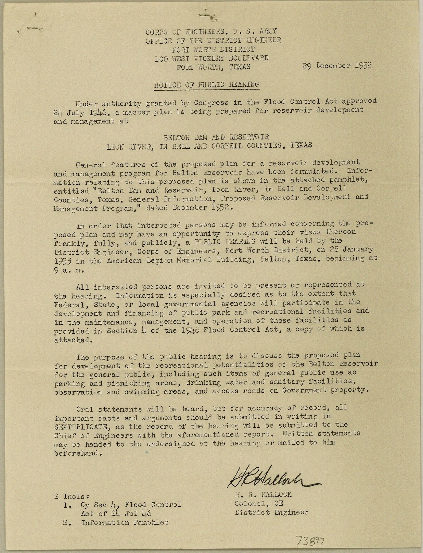
Notice of Public Hearing - Corps of Engineers, Fort Worth District. Belton Dam and Reservoirs, Leon River in Bell and Coryell Counties
-
Map/Doc
73897
-
Collection
General Map Collection
-
Object Dates
1953/1/28 (Creation Date)
-
Subjects
Curiosities
-
Height x Width
10.6 x 8.2 inches
26.9 x 20.8 cm
Part of: General Map Collection
Dawson County Sketch File 7

Print $20.00
- Digital $50.00
Dawson County Sketch File 7
1926
Size 20.0 x 24.6 inches
Map/Doc 11292
Copy of Surveyor's Field Book, Morris Browning - In Blocks 7, 5 & 4, I&GNRRCo., Hutchinson and Carson Counties, Texas

Print $2.00
- Digital $50.00
Copy of Surveyor's Field Book, Morris Browning - In Blocks 7, 5 & 4, I&GNRRCo., Hutchinson and Carson Counties, Texas
1888
Size 7.0 x 8.9 inches
Map/Doc 62268
Travis County Working Sketch 4

Print $20.00
- Digital $50.00
Travis County Working Sketch 4
1906
Size 38.3 x 26.1 inches
Map/Doc 69388
Map of Red River Division of the International & Great Northern Railroad

Print $40.00
- Digital $50.00
Map of Red River Division of the International & Great Northern Railroad
Size 24.1 x 107.0 inches
Map/Doc 64476
Lamar County Sketch File 12

Print $20.00
- Digital $50.00
Lamar County Sketch File 12
Size 19.5 x 23.3 inches
Map/Doc 11967
University Lands Blocks 34 to 37, Terrell County, Isogonic Chart & Meridian Changes

Print $20.00
- Digital $50.00
University Lands Blocks 34 to 37, Terrell County, Isogonic Chart & Meridian Changes
Size 23.2 x 22.4 inches
Map/Doc 62940
Harris County Sketch File 26

Print $8.00
- Digital $50.00
Harris County Sketch File 26
Size 9.2 x 8.5 inches
Map/Doc 25393
Scurry County

Print $20.00
- Digital $50.00
Scurry County
1921
Size 42.4 x 39.1 inches
Map/Doc 95637
Hardin County Rolled Sketch 23

Print $20.00
- Digital $50.00
Hardin County Rolled Sketch 23
1982
Size 28.5 x 45.2 inches
Map/Doc 6091
Brooks County Sketch File 11

Print $14.00
- Digital $50.00
Brooks County Sketch File 11
Size 11.3 x 8.9 inches
Map/Doc 16573
Map of Randall County

Print $20.00
- Digital $50.00
Map of Randall County
1892
Size 24.4 x 18.6 inches
Map/Doc 3975
Travis County Appraisal District Plat Map 2_0502

Print $20.00
- Digital $50.00
Travis County Appraisal District Plat Map 2_0502
Size 21.4 x 26.4 inches
Map/Doc 94236
You may also like
Pecos County Working Sketch 43

Print $40.00
- Digital $50.00
Pecos County Working Sketch 43
1943
Size 19.5 x 50.7 inches
Map/Doc 71515
Johnson County Working Sketch 18

Print $20.00
- Digital $50.00
Johnson County Working Sketch 18
1985
Size 18.3 x 26.0 inches
Map/Doc 66631
Colorado River, LaGrange Sheet

Print $20.00
- Digital $50.00
Colorado River, LaGrange Sheet
1934
Size 37.8 x 32.9 inches
Map/Doc 65302
Harbor Pass and Bar at Brazos Santiago, Texas

Print $20.00
- Digital $50.00
Harbor Pass and Bar at Brazos Santiago, Texas
1879
Size 18.2 x 27.2 inches
Map/Doc 73001
Calhoun County Rolled Sketch 24

Print $40.00
- Digital $50.00
Calhoun County Rolled Sketch 24
1962
Size 26.0 x 58.3 inches
Map/Doc 5373
Calhoun County Rolled Sketch 35

Print $20.00
- Digital $50.00
Calhoun County Rolled Sketch 35
1929
Size 36.2 x 25.6 inches
Map/Doc 5378
Wood County Working Sketch 22

Print $20.00
- Digital $50.00
Wood County Working Sketch 22
1962
Size 45.9 x 36.6 inches
Map/Doc 62022
Brooks County Rolled Sketch 29

Print $20.00
- Digital $50.00
Brooks County Rolled Sketch 29
1947
Size 31.3 x 22.9 inches
Map/Doc 5347
Navarro County Rolled Sketch 7

Print $20.00
- Digital $50.00
Navarro County Rolled Sketch 7
Size 45.0 x 34.6 inches
Map/Doc 10308
Padre Island National Seashore

Print $4.00
- Digital $50.00
Padre Island National Seashore
Size 16.0 x 22.3 inches
Map/Doc 60532
Cameron County Rolled Sketch Z6

Print $20.00
- Digital $50.00
Cameron County Rolled Sketch Z6
1937
Size 28.3 x 33.8 inches
Map/Doc 5404
Travis County Sketch File 23

Print $4.00
- Digital $50.00
Travis County Sketch File 23
1875
Size 12.8 x 8.5 inches
Map/Doc 38330