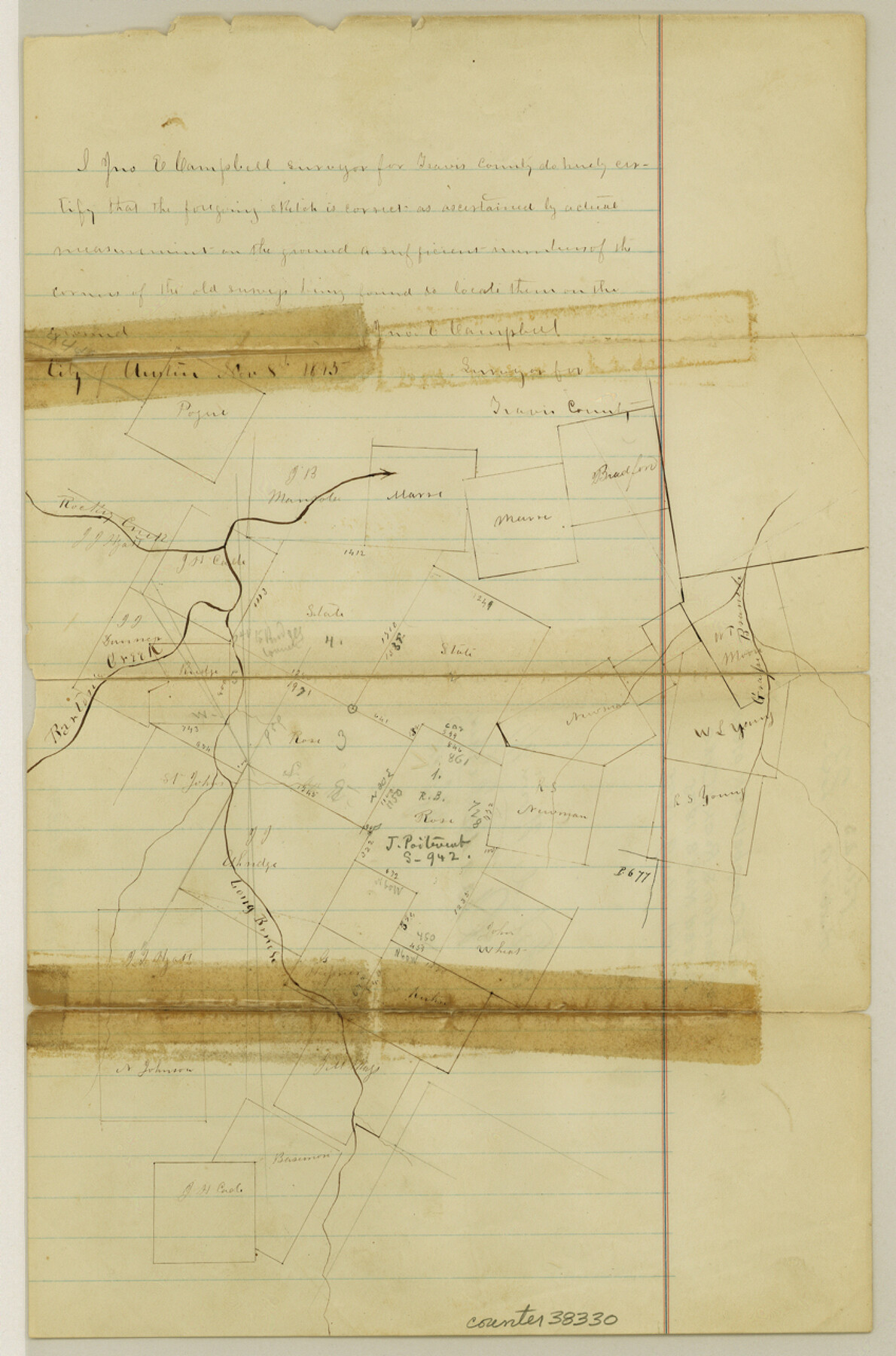
Travis County Sketch File 23
[Sketch of surveys in the vicinity of the confluence of Barton Creek, Rocky Creek, and Long Branch west of Austin]
-
Map/Doc
38330
-
Collection
General Map Collection
-
Object Dates
11/8/1875 (Creation Date)
11/9/1875 (File Date)
-
People and Organizations
Jno. E. Campbell (Surveyor/Engineer)
-
Counties
Travis
-
Subjects
Surveying Sketch File
-
Height x Width
12.8 x 8.5 inches
32.5 x 21.6 cm
-
Medium
paper, manuscript
-
Features
Rocky Creek
Barton's Creek
Grape Branch
Long Branch
Part of: General Map Collection
Val Verde County Rolled Sketch 28

Print $20.00
- Digital $50.00
Val Verde County Rolled Sketch 28
Size 28.5 x 36.1 inches
Map/Doc 8110
General Chart of the Coast No. XXI Gulf Coast from Galveston to the Rio Grande

Print $20.00
- Digital $50.00
General Chart of the Coast No. XXI Gulf Coast from Galveston to the Rio Grande
1883
Size 27.2 x 18.3 inches
Map/Doc 72728
Hall County Sketch File 10

Print $20.00
- Digital $50.00
Hall County Sketch File 10
1884
Size 19.6 x 22.1 inches
Map/Doc 11605
Shackelford County Working Sketch 7

Print $20.00
- Digital $50.00
Shackelford County Working Sketch 7
1963
Size 22.4 x 23.3 inches
Map/Doc 63847
Hudspeth County Sketch File 4-5-6

Print $2.00
- Digital $50.00
Hudspeth County Sketch File 4-5-6
Size 8.8 x 8.1 inches
Map/Doc 26891
Part of the boundary between the Republic of Texas and the United States, North of Sabine River, from the 72nd Mile Mound to Red River (Sheet No. 3)

Print $20.00
- Digital $50.00
Part of the boundary between the Republic of Texas and the United States, North of Sabine River, from the 72nd Mile Mound to Red River (Sheet No. 3)
1842
Size 33.8 x 26.2 inches
Map/Doc 4670
Caddo Lake and Subdivision

Print $20.00
- Digital $50.00
Caddo Lake and Subdivision
1918
Size 35.0 x 29.8 inches
Map/Doc 93283
Reagan County Rolled Sketch 22

Print $20.00
- Digital $50.00
Reagan County Rolled Sketch 22
Size 33.9 x 33.1 inches
Map/Doc 9817
Goliad County Sketch File 14

Print $4.00
- Digital $50.00
Goliad County Sketch File 14
1878
Size 8.6 x 11.4 inches
Map/Doc 24243
Marion County Sketch File 12

Print $20.00
- Digital $50.00
Marion County Sketch File 12
1912
Size 25.1 x 14.2 inches
Map/Doc 12022
Flight Mission No. DQN-6K, Frame 11, Calhoun County

Print $20.00
- Digital $50.00
Flight Mission No. DQN-6K, Frame 11, Calhoun County
1953
Size 18.4 x 22.2 inches
Map/Doc 84433
Cass County Working Sketch 15

Print $20.00
- Digital $50.00
Cass County Working Sketch 15
1957
Size 29.7 x 19.0 inches
Map/Doc 67918
You may also like
Map of the United States constructed from the latest authorities

Print $20.00
- Digital $50.00
Map of the United States constructed from the latest authorities
1825
Size 19.4 x 24.5 inches
Map/Doc 93924
[Sections 58-63, I. & G. N. Block 1 and adjacent area to the west]
![91641, [Sections 58-63, I. & G. N. Block 1 and adjacent area to the west], Twichell Survey Records](https://historictexasmaps.com/wmedia_w700/maps/91641-1.tif.jpg)
Print $20.00
- Digital $50.00
[Sections 58-63, I. & G. N. Block 1 and adjacent area to the west]
Size 22.6 x 14.8 inches
Map/Doc 91641

Carte du Spits-Berg, et partie de la Côte de Galles hams-kes au nouveau Groenland

Print $20.00
- Digital $50.00
Carte du Spits-Berg, et partie de la Côte de Galles hams-kes au nouveau Groenland
1782
Size 13.8 x 19.8 inches
Map/Doc 97123
[Movements & Objectives of the 143rd & 144th Infantry & 133rd Machine Gun Battalion on October 8-9, 1918, Appendix E, No. 4] - Verso
![94134, [Movements & Objectives of the 143rd & 144th Infantry & 133rd Machine Gun Battalion on October 8-9, 1918, Appendix E, No. 4] - Verso, Non-GLO Digital Images](https://historictexasmaps.com/wmedia_w700/maps/94134-1.tif.jpg)
Print $20.00
[Movements & Objectives of the 143rd & 144th Infantry & 133rd Machine Gun Battalion on October 8-9, 1918, Appendix E, No. 4] - Verso
1918
Size 21.5 x 20.0 inches
Map/Doc 94134
Gray County Boundary File 10

Print $15.00
- Digital $50.00
Gray County Boundary File 10
Size 14.5 x 9.0 inches
Map/Doc 53905
Galveston County NRC Article 33.136 Sketch 19

Print $50.00
- Digital $50.00
Galveston County NRC Article 33.136 Sketch 19
2002
Size 37.1 x 25.4 inches
Map/Doc 78491
Sketch, Val Verde County, Part of Blk. D-7 E. L. & R. R. Ry., Survey for Mrs. Geo. Baker, P. Bradford et. al.

Print $20.00
- Digital $50.00
Sketch, Val Verde County, Part of Blk. D-7 E. L. & R. R. Ry., Survey for Mrs. Geo. Baker, P. Bradford et. al.
1937
Size 18.2 x 16.2 inches
Map/Doc 91873
Trinity River, Kaufman Sheet/Kings Creek

Print $6.00
- Digital $50.00
Trinity River, Kaufman Sheet/Kings Creek
1930
Size 32.6 x 27.0 inches
Map/Doc 65228
Kleberg County

Print $20.00
- Digital $50.00
Kleberg County
1913
Size 27.2 x 34.4 inches
Map/Doc 5006
[Sketch of Elizabeth Stanley and Wm. Rivers surveys]
![91982, [Sketch of Elizabeth Stanley and Wm. Rivers surveys], Twichell Survey Records](https://historictexasmaps.com/wmedia_w700/maps/91982-1.tif.jpg)
Print $20.00
- Digital $50.00
[Sketch of Elizabeth Stanley and Wm. Rivers surveys]
Size 23.3 x 10.3 inches
Map/Doc 91982
Webb County Sketch File 13b

Print $3.00
- Digital $50.00
Webb County Sketch File 13b
1893
Size 14.0 x 9.8 inches
Map/Doc 39803