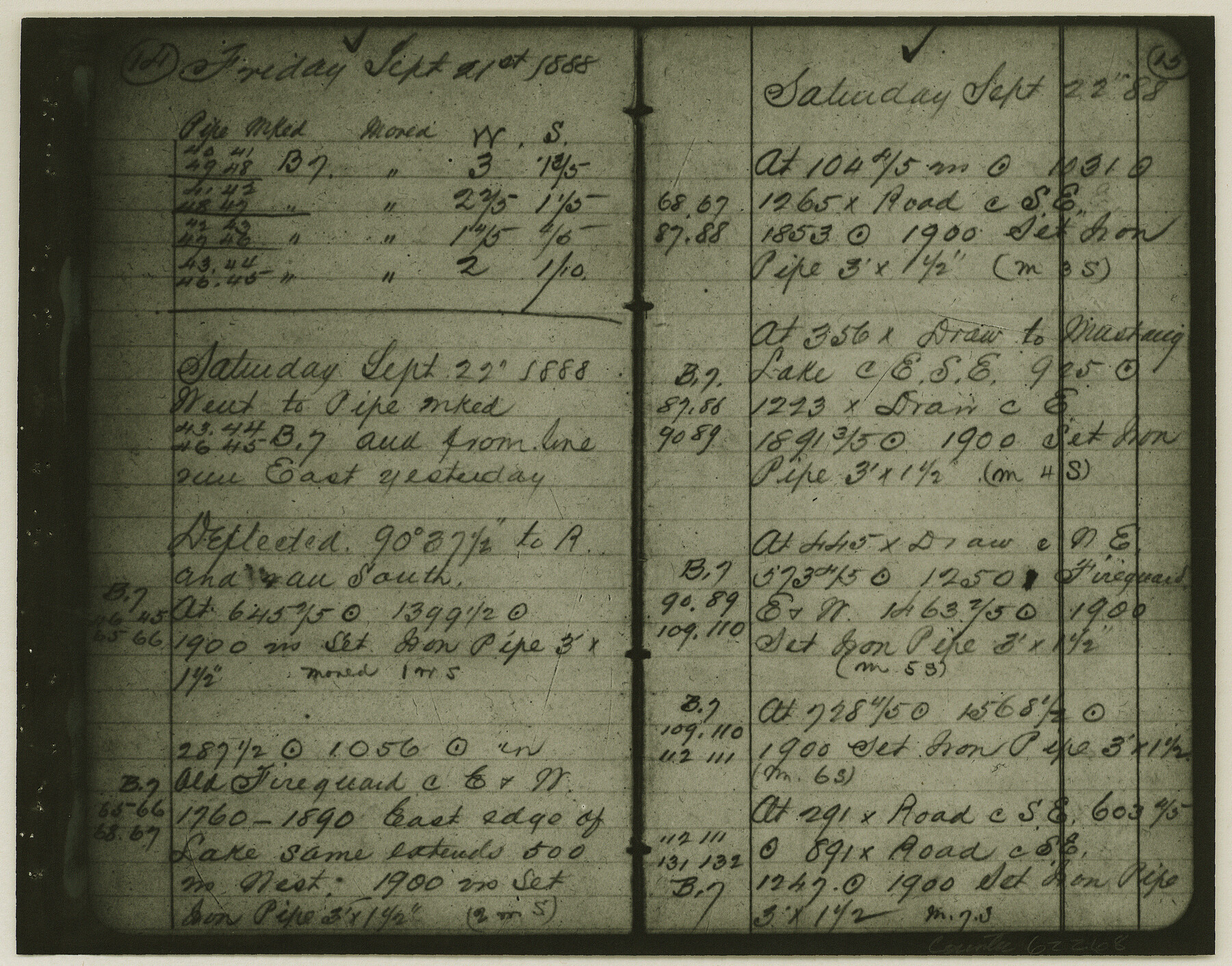
Copy of Surveyor's Field Book, Morris Browning - In Blocks 7, 5 & 4, I&GNRRCo., Hutchinson and Carson Counties, Texas
K-7-70
-
Map/Doc
62268
-
Collection
General Map Collection
-
Object Dates
1888/10/22 (Creation Date)
-
People and Organizations
Morris Browning (Surveyor/Engineer)
-
Counties
Hutchinson Carson
-
Height x Width
7.0 x 8.9 inches
17.8 x 22.6 cm
-
Comments
Copy of Surveyor's field book presented to the General Land Office by Morris Browning on February 3, 1941.
Surveyed from September 14, 1888 to October 22, 1888.
Part of: General Map Collection
Flight Mission No. CRC-2R, Frame 199, Chambers County

Print $20.00
- Digital $50.00
Flight Mission No. CRC-2R, Frame 199, Chambers County
1956
Size 18.6 x 22.4 inches
Map/Doc 84777
Liberty County Working Sketch 85

Print $20.00
- Digital $50.00
Liberty County Working Sketch 85
1987
Size 27.2 x 28.3 inches
Map/Doc 70545
Webb County Working Sketch 84

Print $20.00
- Digital $50.00
Webb County Working Sketch 84
1979
Size 27.0 x 24.3 inches
Map/Doc 72451
Hamilton County Working Sketch 18

Print $20.00
- Digital $50.00
Hamilton County Working Sketch 18
1952
Size 22.4 x 25.1 inches
Map/Doc 63356
Hudspeth County Rolled Sketch 17

Print $40.00
- Digital $50.00
Hudspeth County Rolled Sketch 17
1886
Size 22.3 x 118.5 inches
Map/Doc 9203
Kimble County Rolled Sketch 35

Print $20.00
- Digital $50.00
Kimble County Rolled Sketch 35
1978
Size 20.0 x 19.6 inches
Map/Doc 6525
Flight Mission No. DQN-6K, Frame 72, Calhoun County

Print $20.00
- Digital $50.00
Flight Mission No. DQN-6K, Frame 72, Calhoun County
1953
Size 18.4 x 22.0 inches
Map/Doc 84444
[F. W. & D. C. Ry. Co. Alignment and Right of Way Map, Clay County]
![64737, [F. W. & D. C. Ry. Co. Alignment and Right of Way Map, Clay County], General Map Collection](https://historictexasmaps.com/wmedia_w700/maps/64737-GC.tif.jpg)
Print $20.00
- Digital $50.00
[F. W. & D. C. Ry. Co. Alignment and Right of Way Map, Clay County]
1927
Size 18.6 x 11.8 inches
Map/Doc 64737
Goliad County Working Sketch 25

Print $20.00
- Digital $50.00
Goliad County Working Sketch 25
1994
Size 19.6 x 21.9 inches
Map/Doc 63215
Flight Mission No. DIX-7P, Frame 15, Aransas County

Print $20.00
- Digital $50.00
Flight Mission No. DIX-7P, Frame 15, Aransas County
1956
Size 18.8 x 22.8 inches
Map/Doc 83867
Red River County Sketch File 7

Print $6.00
- Digital $50.00
Red River County Sketch File 7
1855
Size 12.7 x 8.0 inches
Map/Doc 35109
El Paso County Rolled Sketch 16

Print $40.00
- Digital $50.00
El Paso County Rolled Sketch 16
1885
Size 21.5 x 52.0 inches
Map/Doc 8855
You may also like
San Jacinto County Working Sketch 36

Print $40.00
- Digital $50.00
San Jacinto County Working Sketch 36
1964
Size 33.0 x 57.2 inches
Map/Doc 63749
Matagorda County Rolled Sketch 16A

Print $20.00
- Digital $50.00
Matagorda County Rolled Sketch 16A
Size 23.6 x 41.1 inches
Map/Doc 6683
Somervell County

Print $20.00
- Digital $50.00
Somervell County
1941
Size 25.1 x 24.1 inches
Map/Doc 77424
Shackelford County Working Sketch 8

Print $20.00
- Digital $50.00
Shackelford County Working Sketch 8
1973
Size 31.9 x 28.7 inches
Map/Doc 63848
Map of the Country Adjacent to the Left Bank of the Rio Grande below Matamoros

Print $20.00
Map of the Country Adjacent to the Left Bank of the Rio Grande below Matamoros
1847
Size 27.8 x 22.8 inches
Map/Doc 79731
Kimble County Working Sketch 47

Print $20.00
- Digital $50.00
Kimble County Working Sketch 47
1951
Size 42.9 x 24.3 inches
Map/Doc 70115
Donley County Rolled Sketch 1

Print $20.00
- Digital $50.00
Donley County Rolled Sketch 1
1939
Size 19.6 x 15.1 inches
Map/Doc 5728
Flight Mission No. DQN-1K, Frame 129, Calhoun County

Print $20.00
- Digital $50.00
Flight Mission No. DQN-1K, Frame 129, Calhoun County
1953
Size 18.5 x 22.2 inches
Map/Doc 84192
Hemphill County Rolled Sketch 4

Print $40.00
- Digital $50.00
Hemphill County Rolled Sketch 4
Size 29.7 x 55.1 inches
Map/Doc 6186
Maps of Gulf Intracoastal Waterway, Texas - Sabine River to the Rio Grande and connecting waterways including ship channels

Print $20.00
- Digital $50.00
Maps of Gulf Intracoastal Waterway, Texas - Sabine River to the Rio Grande and connecting waterways including ship channels
1966
Size 14.5 x 22.3 inches
Map/Doc 61936
English Field Notes of the Spanish Archives - Book 1

English Field Notes of the Spanish Archives - Book 1
1833
Map/Doc 96527
Map of the Territory of the United States from the Mississippi to the Pacific Ocean ordered by the Hon. Jeff'n Davis, Secretary of War to accompany the reports of the explorations for a railroad route

Print $40.00
- Digital $50.00
Map of the Territory of the United States from the Mississippi to the Pacific Ocean ordered by the Hon. Jeff'n Davis, Secretary of War to accompany the reports of the explorations for a railroad route
Size 48.6 x 50.7 inches
Map/Doc 94276